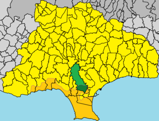
Kyrenia District is one of the six districts of Cyprus. Its main town is Kyrenia. It is the smallest of Cyprus' districts, and is the only one controlled in its entirety by the unrecognised de facto state of Northern Cyprus, where the same territory is administered as the de facto Girne District, a distinct entity.
Xylotymbou is a small town in Larnaca District in south-eastern Cyprus. It is one of the four enclaves surrounded by the Eastern Sovereign Base Area of Akrotiri and Dhekelia, a British Overseas Territory, administered as a Sovereign Base Area. The others are the village of Ormidhia and Dhekelia Power Station. It is administered by the internationally recognized government of Cyprus, the Republic of Cyprus.

Ayios Dhometios is a suburb located west of the Cypriot capital Nicosia. It has a population of 12,456 making it one of Cyprus's biggest municipalities. There is also a population of 2,314 within the area of Ayios Dhometios under Turkish control.

Kakopetria is a town in Cyprus located 55 kilometres (34 mi) southwest of the capital, Nicosia, on the north facing foothills of the Troodos Mountains. It stands at an altitude of 667 metres and it is the highest village in the Solea Valley. The community has about 1,200 permanent inhabitants and a couple hundred more who either have a summer house or are originally from Kakopetria but work in Nicosia. Near Kakopetria there is church from 11th century, Agios Nikolaos tis Stegis, UNESCO World Heritage Site.

Ypsonas is a municipality in Limassol prefecture of the Republic of Cyprus. It is one of the largest villages in the Limassol District of Cyprus and is located about 7 kilometers west of Limassol city. The southern part of the village is within the administrative borders of the British military base of Akrotiri - Episkopi. It has 10,916 residents as recorded in the Census of 2011.

Agios Mamas is a small village in the Limassol region of Cyprus. It is located on the southern slopes of the Troodos mountain range in the area famous for its Commandaria wine.

Politiko is a village located in the Nicosia District of Cyprus. The hamlet of Filani is part of this municipality.

Esentepe is a village located in the Girne District of Cyprus, east of Girne. It is under the de facto control Northern Cyprus.

Agios Sozomenos is a deserted village in the Nicosia District of Cyprus, close to the Green Line and near Potamia. It is located at the confluence of the Alikos river with the Gialias, the second-longest river of Cyprus.
Fterikoudi is a village in the Nicosia District of Cyprus, located 4 km north of Palaichori Morphou.
Asha, also transliterated Assia, is a village in the Famagusta District of Cyprus, located 6 km northwest of Vatili. It is under the de facto control of Northern Cyprus.

Angastina is a village in the Famagusta District of Cyprus, located around 20 km east of Nicosia, on the main road to Famagusta. It is under the de facto control of Northern Cyprus. Angastina is perched on a gentle river terrace chalk escarpment over the Pedias river plain at 66 metres above sea level.
Agios Ilias is a village in the Famagusta District of Cyprus, located 6 kilometres (3.7 mi) north-east of Trikomo. It is under the de facto control of Northern Cyprus.
Mesana is a village in the Paphos District of Cyprus, located 2 km northeast of Salamiou.
Lemona is a village in the Paphos District of Cyprus, located about 25 km northeast of the town of Paphos and 7 km west of Agios Fotios.
Kourtaka or Kourdaka is an abandoned Turkish Cypriot village in the Paphos District of Cyprus, located 8 km west of Ayios Photios. A settlement between Choulou and Letymvou, Kourdaka is a rare case of a community that has overcome desertion and abandonment, and instead, it has gained new life since 2012 with newcomers who have chosen to live in the area.

Agios Dimitrianos is a village in the Paphos District of Cyprus, located 12 km west of Pano Panagia. Agios Dimitrianos has an elevation of 564 m. The village was named after the church of Agios Dimitrianos located in the area where the village was built. Nearby Communities : Polemi, Psathi. Built at an elevation of 550 meters among low hills and many vineyards, Agios Dimitrianos is a small settlement of approximately 70 inhabitants who live in traditional stone houses with wooden doors and balconies. Tourist accommodation includes rooms for rent and traditional guesthouses.
Pitargou is an abandoned Turkish Cypriot village in the Paphos District of Cyprus, located 3 km south of Letymvou. Pitargou is located 286m above sea level.

Tremithousa is a village in the Paphos District of Cyprus, located 7 km north of Paphos. Tremithousa is located 294 m above sea level. Tremithousa is located near Mesa Chorio and Mesogi Village. Tremithousa receives an average annual rainfall of about 520 millimeters; vines of winemaking varieties, vegetables, cereals, forage plants, citrus, almond, and walnut trees, and legumes are cultivated in the region. The village has a reputation for the aromatic and tasty honey that it produces. Tremithousa connects in the north to the monastery of Agios Neofytos, in the northeast with the village of Tala, and in the east with the main road of Tsada – Polis.

Limassol District or Lemesos is one of the six districts of Cyprus. As of 2011, it had a population of 239,842, 77% of which was urban. Its main city is Limassol. Part of the British Overseas Territory of Akrotiri and Dhekelia forms an enclave on the Akrotiri Peninsula, under the sovereignty of the United Kingdom.


