Sasso di Bordighera

Last updated
Sasso di Bordighera
Sasso panorama.png
Village centre
Italy provincial location map 2016.svg
Red pog.svg
Sasso di Bordighera
Location of Sasso di Bordighera in Italy
Coordinates: 43°48′14.09″N7°40′18.36″E / 43.8039139°N 7.6717667°E / 43.8039139; 7.6717667 Coordinates: 43°48′14.09″N7°40′18.36″E / 43.8039139°N 7.6717667°E / 43.8039139; 7.6717667
CountryFlag of Italy.svg  Italy
Region Flag of Liguria.svg  Liguria
Province Imperia (IM)
Comune Bordighera
Elevation
[1]
219 m (719 ft)
Population
 (2001)Istat - 14º Censimento generale della popolazione e delle abitazioni
  Total212
Time zone UTC+1 (CET)
  Summer (DST) UTC+2 (CEST)
Postal code
18012
Dialing code (+39) 0184

Sasso di Bordighera is a frazione (and parish) of the municipality of Bordighera, in Liguria, northern Italy.

Contents

Geography

Medioeval house Sasso casa torre.png
Medioeval house

Sasso di Bordighera is located on a hilly ridge dividing the short valleys of Borghetto (west) and Sasso streams. , [2]

History

Parish church vault Sasso volta chiesa ss pietro e paolo attrib carrega.png
Parish church vault

Sasso di Bordighera was founded, following a local tradition, by the inhabitants of the neighbouring city of Taggia. The village is located on a rocky summit and its oldest part is made of tower-shaped houses. On the 21st of April 1686, the representants of eight villages, Camporosso, Vallebona, Vallecrosia, San Biagio della Cima, Sasso, Soldano, Borghetto San Nicolò and Bordighera had a meeting in order to build what they called "Magnifica Comunità degli Otto Luoghi", which can be translated as: "The magnificent community of the eight villages". Their goal was to gain independence from the nearby rival city of Ventimiglia. [3] At the beginning of the 20th century Sasso was linked to the coast with a new road which, starting from Bordighera, continues up to Seborga. [3]

Sasso di Bordighera was a separate comune (municipality) until 1928 when, with Borghetto San Nicolò (which also was an autonomous municipality) was joined with Bordighera. [4]

Bibliography

Related Research Articles

Bordighera Comune in Liguria, Italy

Bordighera is a town and comune in the Province of Imperia, Liguria (Italy).

Soldano, Liguria Comune in Liguria, Italy

Soldano is a town and comune in the province of Imperia, Liguria (Italy).

Borghetto dArroscia Comune in Liguria, Italy

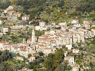
Borghetto d'Arroscia is a comune (municipality) in the Province of Imperia in the Italian region Liguria, located about 90 kilometres (56 mi) southwest of Genoa and about 20 kilometres (12 mi) north of Imperia.

Camporosso Comune in Liguria, Italy

Camporosso is a comune (municipality) in the Province of Imperia in the Italian region Liguria, located about 160 kilometres (99 mi) southwest of Genoa and about 45 kilometres (28 mi) west of Imperia.

Diano Castello municipality in Liguria, Italy

Diano Castello is a comune (municipality) in the Province of Imperia in the Italian region Liguria, located about 90 kilometres (56 mi) southwest of Genoa and about 5 kilometres (3 mi) northeast of Imperia. As of 31 December 2004, it had a population of 2,061 and an area of 6.0 square kilometres (2.3 sq mi).

Ospedaletti Comune in Liguria, Italy

Ospedaletti is a comune (municipality) in the Province of Imperia in the Italian region of Liguria, located about 120 kilometres (75 mi) southwest of Genoa and about 25 kilometres (16 mi) southwest of Imperia.

Pieve di Teco Comune in Liguria, Italy

Pieve di Teco is a comune (municipality) in the Province of Imperia in the Italian region Liguria, located about 90 kilometres (56 mi) southwest of Genoa and about 20 kilometres (12 mi) northwest of Imperia.

Ranzo Comune in Liguria, Italy

Ranzo is a comune (municipality) in the Province of Imperia in the Italian region Liguria, located about 80 kilometres (50 mi) southwest of Genoa and about 20 kilometres (12 mi) north of Imperia.

San Biagio della Cima Comune in Liguria, Italy

San Biagio della Cima is a comune (municipality) in the Province of Imperia in the Italian region Liguria, located about 120 kilometres (75 mi) southwest of Genoa and about 30 kilometres (19 mi) west of Imperia.

Vallebona Comune in Liguria, Italy

Vallebona is a comune (municipality) in the Province of Imperia in the Italian region Liguria, located about 120 kilometres (75 mi) southwest of Genoa and about 30 kilometres (19 mi) west of Imperia. Vallebona borders the following municipalities: Bordighera, Ospedaletti, Perinaldo, San Biagio della Cima, Seborga, Soldano, and Vallecrosia.

Vallecrosia Comune in Liguria, Italy

Vallecrosia is a comune (municipality) in the Province of Imperia in the Italian region Liguria, located about 120 kilometres (75 mi) southwest of Genoa and about 30 kilometres (19 mi) west of Imperia. It is next to the busy city of Ventimiglia.

Vessalico Comune in Liguria, Italy

Vessalico is a comune (municipality) in the Province of Imperia in the Italian region Liguria, located about 90 kilometres (56 mi) southwest of Genoa and about 20 kilometres (12 mi) northwest of Imperia.

St. Bartholomew Oratory (Bordighera) Church in Bordighera, Italy

The Oratory of Saint Bartholomew is a religious building in the centre of old Bordighera in the Riviera, Province of Imperia. The building is close to the Church of Saint Mary Magdalen.

Calvisio Frazione in Liguria, Italy

Calvisio is a frazione of the municipality of Finale Ligure, in Liguria, northern Italy.

Borghetto San Nicolò Frazione in Liguria, Italy

Borghetto San Nicolò is a frazione of the municipality of Bordighera, in Liguria, northern Italy.

Steria (creek) stream in Liguria, Italy

The Steria or Cervo is a 9.6-kilometre (6.0 mi) stream of Liguria (Italy).

San Pietro (creek) Stream in Liguria, Italy

The San Pietro or Evigno is a 10.2-kilometre (6.3 mi) stream of Liguria (Italy).

Giara di Rezzo

The Giara di Rezzo is a 14-kilometre (8.7 mi) creek of Liguria, Italy.

Lavina (Rezzo) Frazione in Liguria, Italy

Lavina is a frazione of the municipality of Rezzo, in Liguria, northern Italy. Up to 1928 it was a self-standing comune.

Monte Spinarda

Monte Spinarda is a 1,357-metre (4,452 ft) mountain of the Ligurian Alps, in Italy.

References

  1. Limiti Amministrativi (Comunali, Provinciali, Regionali) sc. 1:25000 - ed. 2011; Regione Liguria, on-line map on geoportale.regione.liguria.it.
  2. Carta 1:25.00, Istituto Geografico Militare (on-line:www.pcn.minambiente.it)
  3. 1 2 Gandolfo, Andrea (2005). La provincia di Imperia: storia, arti, tradizioni. 1. Blu edizioni.
  4. "Comune ISTAT "008008 Bordighera (Imperia)"". www.elesh.it. Retrieved 2016-06-25.

Commons-logo.svg Media related to Sasso (Bordighera) at Wikimedia Commons