Comal County is a county located on the Edwards Plateau in the U.S. state of Texas. As of the 2020 census, its population was 161,501. Comal County is known for its rich German-Texan and European history. Its county seat is New Braunfels.

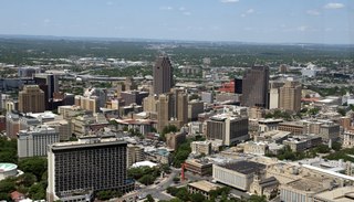
Bexar County is a county in the U.S. state of Texas. It is in South Texas and its county seat is San Antonio.

Canyon Lake is a census-designated place (CDP) in Comal County, Texas, United States. The population was 31,124 at the 2020 census. It is part of the San Antonio Metropolitan Statistical Area.

South Texas is a geographic and cultural region of the U.S. state of Texas that lies roughly south of—and includes—San Antonio. The southern and western boundary is the Rio Grande, and to the east it is the Gulf of Mexico. The population of this region is about 4.96 million according to the 2017 census estimates. The southern portion of this region is often referred to as the Rio Grande Valley. The eastern portion along the Gulf of Mexico is also referred to as the Coastal Bend.

The Guadalupe River runs from Kerr County, Texas, to San Antonio Bay on the Gulf of Mexico, with an average temperature of 17.75 degrees Celsius. It is a popular destination for rafting, fly fishing, and canoeing. Larger cities along it include Kerrville, New Braunfels, Seguin, Gonzales, Cuero, and Victoria. It has several dams along its length, the most notable of which, Canyon Dam, forms Canyon Lake northwest of New Braunfels.

Canyon Lake is a reservoir on the Guadalupe River in the Texas Hill Country in the United States. Canyon Lake is a U.S. Army Corps of Engineers reservoir formed on the Guadalupe River in Comal County by Canyon Dam, which is located about sixteen miles northwest of New Braunfels. The dam, lake, and all adjacent property are managed by the U.S. Army Corps Of Engineers. Water rights, waste water treatment, and hydroelectric generating facilities are managed by the Guadalupe-Blanco River Authority. Construction of the dam began in 1958 and was completed in 1964. The reservoir serves to provide flood control and water supply for the communities downstream from the dam. The lake is also a popular recreational destination.

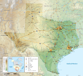
The geography of Texas is diverse and large. Occupying about 7% of the total water and land area of the U.S., it is the second largest state after Alaska, and is the southernmost part of the Great Plains, which end in the south against the folded Sierra Madre Oriental of Mexico. Texas is in the South Central United States of America, and is considered to form part of the U.S. South and also part of the U.S. Southwest.
Comal Independent School District is a public school district based in New Braunfels, Texas (USA).

Spring Branch is a city in Comal County, Texas, United States. It has approximately 250 residents. The community voted to incorporate in an election held on November 3, 2015 and Spring Branch officially became a city on November 19, 2015.
Wallisville is an unincorporated town in northern Chambers County, Texas, United States. According to the Handbook of Texas, the community had a population of 460 in 2000. It is located within the Greater Houston metropolitan area.
Shannon is an unincorporated community in Clay County, Texas, United States. According to the Handbook of Texas, the community had a population of 23 in 2000. It is located within the Wichita Falls metropolitan area.
Canyon City is a neighborhood withing the Canyon Lake census-designated place in Comal County, Texas, United States. According to the Handbook of Texas, the community had a population of 100 in 2000. It is located within the Greater San Antonio area.

Smithson Valley High School is a public high school located in unincorporated Comal County, Texas, and is classified as a 5A school by the UIL. It is part of the Comal Independent School District and is one of the five out of seven traditional high schools within the district. Its student enrollment as of the beginning of the 2022-23 school year is 2,310. Smithson Valley’s student enrollment reached as high as 2,584 in the 2021-22 school year before some students were sent off to the brand-new and recently opened Pieper High School after the 2021-22 school year which was built to deal with the growing population of the school’s attendance zone and to provide relief to Smithson Valley's attendance roster.
Rockwood is an unincorporated community in Coleman County, Texas, United States. According to the Handbook of Texas, the community had a population of 80 in 2000.

Fischer is an unincorporated community in Comal County, Texas, United States. According to the Handbook of Texas, the community had a population of 20 in 2000. It is included in the Greater San Antonio area.

Cedar Hill is a city in Dallas and Ellis counties in the U.S. state of Texas. It is located approximately 16 miles (26 km) southwest of downtown Dallas and is situated along the eastern shore of Joe Pool Lake and Cedar Hill State Park. Per the 2020 United States census, the population was 49,148. Cedar Hill is a suburb of the city of Dallas and is part of the Best Southwest area, which includes the nearby cities of DeSoto, Duncanville, and Lancaster.
Hunter is an unincorporated community in Comal County, Texas, United States. According to the Handbook of Texas, the community had a population of 30 in 2000. It is located within the Greater San Antonio area.
Smithson Valley is a neighborhood within the Canyon Lake census-designated place in Comal County, Texas, United States. According to the Handbook of Texas, the community had a population of 15 in 2000. It is located within the Greater San Antonio area.
Startzville is a neighborhood within the Canyon Lake census-designated place in Comal County, Texas, United States. According to the Handbook of Texas, the community had a population of 30 in 2000. It is located within the Greater San Antonio area.


