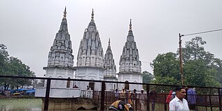
Hardoi is a city and municipal board in Hardoi district in the Indian state of Uttar Pradesh. It is the administrative headquarters of Hardoi district. It is also known as Prahalad Nagari. Hardoi is about 110 km from the state capital Lucknow and about 385 km from New Delhi. Hardoi is a temple town.
Kannauj district is an administrative district of Uttar Pradesh state in northern India, along the river Ganges. The historic town of Kannauj, northwest of Kanpur, is the administrative center. The district was carved out of Farrukhabad district on 18 September 1997. The native dialect of this district is Kannauji.
Hardoi district is a district situated in the center of Uttar Pradesh, India. The district headquarters is in the city of Hardoi. Hardoi is the third largest district of Uttar Pradesh. It falls under Lucknow division in the historical region of Awadh State.
Beniganj is a town and nagar panchayat in Sandila tehsil of Hardoi district, Uttar Pradesh, India. It is located 21 miles southeast of Hardoi and 16 miles north of Sandila, on the road to Nimkhar and Sitapur.
Bilgram is a town and a nagar palika parishad in Hardoi district in the state of Uttar Pradesh, India. It is located 16 miles (26 km) south of the city of Hardoi, on an elevated bluff that once formed the eastern bank of the Ganges. Important industries in Bilgram include ceramics and embroidery.

Kachhauna Patseni is a town and a nagar panchayat in Sandila tehsil of Hardoi district, Uttar Pradesh, India. It was first upgraded to urban status for the 1981 census. As of 2011, its population is 15,647, in 2,772 households. The Kachhauna community development block encompasses the rural areas surrounding the town.
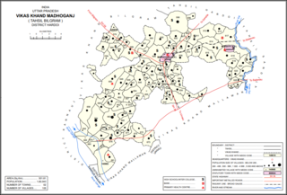
Madhoganj is a town and Nagar Panchayat in Bilgram tehsil of Hardoi district, Uttar Pradesh, India. It is located on the north side of the main road from Sitapur to Kanpur, with other roads leading to Bilgram to the northwest, Mallawan to the south, and Beniganj and Balamau to the east. As of 2011, the population of Madhoganj is 11,523, in 2,180 households. It is also the seat of a community development block.
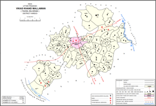
Mallawan, also spelled Mallanwan is a town and Nagar Palika Parishad in Hardoi district of Uttar Pradesh, India. It served as the original district headquarters from 1856 to 1858. It is located south of Bilgram, on the road to Unnao. Mallawan is a major centre of handloom weaving, with handloom cloth being a major export. As of 2011, the population of Mallawan is 36,915, in 6,086 households. It is included in the legislative assembly constituency of Bilgram-Mallanwan.
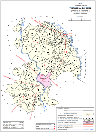
Pihani is a town and nagar palika parishad in Hardoi district of Uttar Pradesh, India. Historically, the city was a centre of sword production, leading to at least one British writer calling it "the Damascus of Oudh". Today, important industries in Pihani include jaggery and woven carpets. As of 2011, the town's population is 36,014, in 5,626 households. Pihani also serves as the headquarters of a community development block in Shahabad tehsil.
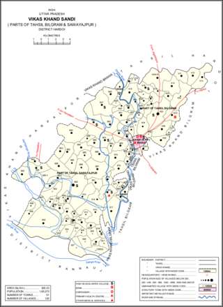
Sandi is a town and a nagar palika parishad in Bilgram tehsil of Hardoi district, Uttar Pradesh, India. It is located on the left bank of the Garra river, on the road from Hardoi to Fatehgarh. As of 2011, its population is 26,007, in 4,396 households.
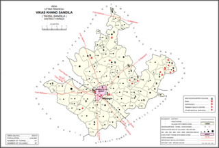
Sandila is a town and nagar palika parishad in Hardoi district in the Indian state of Uttar Pradesh. It serves as a tehsil headquarters within the district. Located midway between Hardoi and Lucknow, Sandila is a well-connected town with roads leading in all directions and a major broad gauge rail line passing through the south side of town. Important industries include sweets — its laddus are especially well-known — as well as beedi production and zardozi work.
Pali is a town and nagar panchayat in Sawayajpur tehsil of Hardoi district, Uttar Pradesh, India. It is on the right bank of the Garra river, 20 miles northwest of Hardoi, Pali historically served as the seat of a pargana and was a regional political headquarters under the Nawabs of Awadh. The town's name is possibly connected to the Pal dynasty that once ruled the nearby city of Kannauj. As of 2011, the population of Pali is 18,708 in 2,949 households.

Harpalpur is a village and corresponding community development block in Sawayajpur tehsil of Hardoi district, Uttar Pradesh, India. It is located west of Sandi, on the road to Fatehgarh. The main staple crops here are wheat, rice, and maize. Markets are held twice weekly. As of 2011, the population of Harpalpur is 8,822, in 1,544 households. The total block population is 172,224, in 29,232 households.
Dasauli is a village in Sandi block of Hardoi district, Uttar Pradesh, India. It is located 10 km away from Sandi, which is the nearest city. The main staple crops are wheat and rice. As of 2011, its population was 1,950, in 291 households.
Nikari is a village in Sandi block of Hardoi district, Uttar Pradesh, India. It is located 8 km (5.0 mi) away from Sandi, which is the nearest city. The village has one primary school, and the main staple crops are wheat and rice. As of 2011, the population of Nikari is 1,878, in 283 households.
Lamkan is a village in Sandi block of Hardoi district, Uttar Pradesh, India. It is located 6 km away from Sandi, which is the nearest city. It is connected to state and national highways and has a sub post office and two primary schools but no healthcare facilities. The main staple crops are wheat and rice. As of 2011, its population is 3,734, in 577 households.

Tadiyawan, also spelled Tandiyawan, is a village and corresponding community development block in Hardoi district of Uttar Pradesh, India. Located 14 km from the city of Hardoi, it hosts a regular market and hosts a Deviji festival on Chaitra Sudi 8 dedicated to worship of the goddess Devi. The village has two primary schools but no healthcare facilities. As of 2011, the population of Tadiyawan is 5,998, in 1,079 households.
Asa is a village in Tadiyawan block of Hardoi district, Uttar Pradesh, India. Located 3 km from the city of Hardoi, the village is connected to state highways and has several schools but no healthcare facilities. The main staple foods are wheat and rice. As of 2011, the population of Asa is 5,734, in 944 households.
Japra is a village in Tadiyawan block of Hardoi district, Uttar Pradesh, India. Located 16 km from the city of Hardoi, the village is not on any major roads and it has 3 primary schools but no healthcare facilities. The main staple foods are wheat and rice. As of 2011, the population of Japra is 3,633, in 555 households.
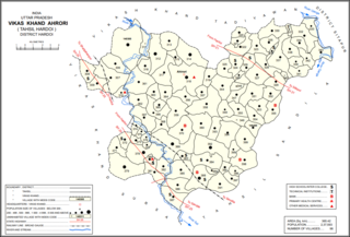
Ahrori, also spelled Ahirori, is a village and corresponding community development block in Hardoi district of Uttar Pradesh, India. Located 24 km from the city of Hardoi, it hosts a regular market and hosts a Babaji festival on Asadha Sudi 15 dedicated to worship of the goddess Devi. The village has two primary schools and one clinic, as well as a public library and a sub post office. As of 2011, the population of Ahrori is 8,382, in 1,329 households.
