Scalasaig

Last updated

Scalasaig
Scalasaig, Colonsay (26636801783).jpg
Argyll and Bute UK location map.svg
Red pog.svg
Scalasaig
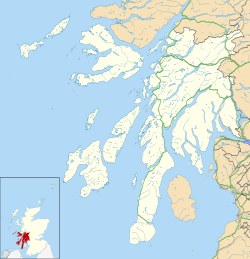
Location within Argyll and Bute
OS grid reference NR394941
  Edinburgh 116 mi (187 km)
  London 400 mi (644 km)
Council area
Lieutenancy area
Country Scotland
Sovereign state United Kingdom
Post town ISLE OF COLONSAY
Postcode district PA61
Dialling code 01951
Police Scotland
Fire Scottish
Ambulance Scottish
UK Parliament
Scottish Parliament
List of places
UK
Scotland
56°04′N6°11′W / 56.07°N 6.18°W / 56.07; -6.18

Scalasaig (Scottish Gaelic : Sgalasaig) lies on the east coast of Colonsay, in the council area of Argyll and Bute of Scotland. It is the main settlement on the island [1] and its only port; thus tourists arriving by ferry must pass through it on the way to any part of the isle. It contains the island's shop [2] and post office (in the same building), [3] parish church, [4] microbrewery, [5] doctor's surgery, [6] village hall, [7] cafe and hotel/bar. [8]
History

The name "Scalasaig" is Norse and means "Skali's bay". [9]

Related Research Articles

<span class="mw-page-title-main">Inner Hebrides</span> Archipelago off the west coast of mainland Scotland

The Inner Hebrides is an archipelago off the west coast of mainland Scotland, to the south east of the Outer Hebrides. Together these two island chains form the Hebrides, which experience a mild oceanic climate. The Inner Hebrides comprise 35 inhabited islands as well as 44 uninhabited islands with an area greater than 30 hectares. Skye, Mull, and Islay are the three largest, and also have the highest populations. The main commercial activities are tourism, crofting, fishing and whisky distilling. In modern times the Inner Hebrides have formed part of two separate local government jurisdictions, one to the north and the other to the south. Together, the islands have an area of about 4,130 km2 (1,594 sq mi), and had a population of 18,948 in 2011. The population density is therefore about 4.6 inhabitants per square kilometre.

<span class="mw-page-title-main">Lamlash</span> Town in Scotland

Lamlash is a village on the Isle of Arran, in the Firth of Clyde, Scotland. It lies three miles south of the island's main settlement and ferry port Brodick, in a sheltered bay on the island's east coast, facing the Holy Isle. Lamlash is the seat of Arran's local government offices, and is also the location of the island's police station, secondary school and hospital. In common with the rest of the island, the village's main industry is tourism and the public sector is also an important employer. Lamlash has an RNLI Lifeboat station with a B class Atlantic 75 lifeboat, covering the inshore waters around the coast of Arran, and in summer, there is a regular ferry service from Lamlash harbour to Holy Isle. The village has several buildings of historical interest, including Hamilton Terrace, which consists of two rows of single storey-and-attic cottages on the Lamlash seafront, arranged in pairs.

<span class="mw-page-title-main">Argyll</span> Historic county and registration county of western Scotland

Argyll, sometimes called Argyllshire, is a historic county and registration county of western Scotland.

<span class="mw-page-title-main">Gigha</span> Island in Scotland

Gigha or the Isle of Gigha is an island off the west coast of Kintyre in Scotland. The island forms part of Argyll and Bute and has a population of 163 people. The climate is mild with higher than average sunshine hours and the soils are fertile. The main settlement is Ardminish.

<span class="mw-page-title-main">Oronsay, Colonsay</span> Small tidal island south of Colonsay in the Scottish Inner Hebrides

Oronsay, also sometimes spelt and pronounced Oransay by the local community, is a small tidal island south of Colonsay in the Scottish Inner Hebrides with an area of 543 hectares.

<span class="mw-page-title-main">Castlebay</span> Village on Barra, Outer Hebrides, Scotland

Castlebay is the main village and a community council area on the island of Barra in the Outer Hebrides, Scotland. The village is located on the south coast of the island, and overlooks a bay in the Atlantic Ocean dominated by Kisimul Castle, as well as nearby islands such as Vatersay. Castlebay is also within the parish of Barra. The village is located on the A888, which serves as a circular road around Barra. In 1971, it had a population of 307.

<span class="mw-page-title-main">Craighouse</span> Human settlement in Scotland

Craighouse is the main settlement and capital of the Scottish Inner Hebridean island of Jura, in Argyll and Bute. In 1971 it had a population of 113. The village is situated on the sheltered east coast of the island at the southern end of Small Isles Bay, on the Sound of Jura.

<span class="mw-page-title-main">Kildonan, Arran</span> Human settlement in Scotland

Kildonan is a village on the south coast of the Isle of Arran in the Firth of Clyde, Scotland. The village is within the parish of Kilmory.

<span class="mw-page-title-main">Oban Airport</span> Airport in North Connel, Argyll and Bute

Oban Airport is located 5 nautical miles northeast of Oban, near the village of North Connel, Argyll and Bute, Scotland. Operated by Argyll and Bute council, it has a CAA licence as a commercial airport following recent upgrading. Currently Hebridean Air Services is the only airline based at Oban. It operates scheduled flights on two routes, to the Isles of Colonsay and Islay return and to the Isles of Coll and Tiree return.

<span class="mw-page-title-main">Clan Macfie</span> Scottish clan

Clan Macfie is a Highlands Scottish Clan.

Colonsay Airport is located on the island of Colonsay, Argyll and Bute, Scotland. Located 3 nautical miles west of Scalasaig, it is a small airport, with 25-minute flights every Tuesday and Thursday to Oban Airport by Hebridean Air Services. Scheduled services commenced in 2006 after the grass airfield was upgraded with a paved runway.

<span class="mw-page-title-main">Hinba</span>

Hinba is an island in Scotland of uncertain location that was the site of a small monastery associated with the Columban church on Iona. Although a number of details are known about the monastery and its early superiors, and various anecdotes dating from the time of Columba of a mystical nature have survived, modern scholars are divided as to its whereabouts. The source of information about the island is Adomnán's late 7th-century Vita Columbae.

<span class="mw-page-title-main">Oban</span> Coastal town in Scotland

Oban is a resort town within the Argyll and Bute council area of Scotland. Despite its small size, it is the largest town between Helensburgh and Fort William. During the tourist season, the town can have a temporary population of up to over 24,000 people. Oban occupies a setting in the Firth of Lorn. The bay forms a near perfect horseshoe, protected by the island of Kerrera; and beyond Kerrera, the Isle of Mull. To the north are the long low island of Lismore and the mountains of Morvern and Ardgour.

<span class="mw-page-title-main">Colonsay</span> Island in the Inner Hebrides of Scotland

Colonsay is an island in the Inner Hebrides of Scotland, located north of Islay and south of Mull. The ancestral home of Clan Macfie and the Colonsay branch of Clan MacNeil, it is in the council area of Argyll and Bute and has an area of 4,074 hectares. Aligned on a south-west to north-east axis, it measures 8 miles in length and reaches 3 mi (5 km) at its widest point.

<span class="mw-page-title-main">Jura, Scotland</span> Island of the Inner Hebrides off Great Britain

Jura is an island in the Inner Hebrides of Scotland, adjacent to and northeast of Islay. With an area of 36,692 hectares (142 sq mi), and 196 inhabitants recorded in the 2011 census, Jura is more sparsely populated than Islay, and is one of the least densely populated islands of Scotland: in a list of the islands of Scotland ranked by size, Jura comes eighth, whereas by population it comes 31st. The island is mountainous, bare and largely infertile, covered by extensive areas of blanket bog.

<span class="mw-page-title-main">Islay</span> Island of the Inner Hebrides of Scotland

Islay is the southernmost island of the Inner Hebrides of Scotland. Known as "The Queen of the Hebrides", it lies in Argyll and Bute just south west of Jura and around 40 kilometres north of the Northern Irish coast. The island's capital is Bowmore where the distinctive round Kilarrow Parish Church and a distillery are located. Port Ellen is the main port.

<span class="mw-page-title-main">St Cathan's Chapel</span>

St Cathan's Chapel is a ruined chapel on the island of Colonsay, Scotland in the Inner Hebrides. It was dedicated to Cathan, an obscure saint once venerated across the western Scottish islands. It is located at grid reference NR3629095026, in the settlement of Lower Kilchattan.

Saint Cathan, also known as Catan, Cattan, etc., was a 6th-century Irish monk revered as a saint in parts of the Scottish Hebrides.

<span class="mw-page-title-main">Colonsay Hotel</span> Historic building in Scotland

Colonsay Hotel is a Category B listed building in Scalasaig, Colonsay in the county of Argyll, in western Scotland.

<span class="mw-page-title-main">Colonsay Parish Church, Scalasaig</span> Church in Argyll and Bute, Scotland

Colonsay Parish Church is a Category B listed Church of Scotland parish church in Scalasaig, Colonsay.

References

  1. "Scalasaig". Gazetteer for Scotland . Retrieved 28 December 2020.
  2. "Home". Colonsay General Store. Retrieved 28 December 2020.
  3. "The Post Office". Isle of Colonsay. Retrieved 28 December 2020.
  4. "Colonsay Church". Isle of Colonsay. Retrieved 28 December 2020.
  5. "Colonsay Beverages Ltd, Scalasaig". Visit Scotland. Retrieved 28 December 2020.
  6. "Scalasaig Medical Practice". Spanglefish. Retrieved 28 December 2020.
  7. "Home". Colonsay Village Hall. Retrieved 28 December 2020.
  8. "Home". The Colonsay Pantry. Retrieved 28 December 2020.
  9. "Placenames P-Z" (PDF). Scottish Parliament. Retrieved 28 December 2020.