
Macomb County is a county located in the eastern portion of the U.S. state of Michigan and is part of metro Detroit. As of the 2010 census, the population was 840,978, making it the third-most populous county in the state. Of Michigan's five largest counties, Macomb experienced the most population growth (102.5%) between 1950 and 1960. The county seat is Mt. Clemens.

Center Line is a city in Macomb County in the U.S. state of Michigan, surrounded entirely by the city of Warren. The population was 8,257 at the 2010 census.

Macomb Township is a civil township within Metro Detroit in Macomb County in the U.S. state of Michigan. The township's population was 50,477 at the 2000 Census. The population at the 2010 Census was 79,580, making it Michigan's fastest growing major municipality and by far the state's most populous civil township.
Roseville is a city in Macomb County in the U.S. state of Michigan, and is a part of the Metro Detroit area. The population was 47,299 at the 2010 census. Until 1958, Roseville was a part of Erin Township.

Shelby Charter Township, officially the Charter Township of Shelby, is a charter township and census-designated place located in Macomb County in the U.S. state of Michigan. The township, an affluent northern suburb of Detroit, is located roughly 15 miles north of the city. As of the 2000 census, the township had a total population of 65,159. The 2010 Census places the population at 73,804. Shelby Charter Township is one of the fastest growing communities in Metro Detroit.

Southfield is a city in Oakland County of the U.S. state of Michigan. It is a northern suburb of Detroit. As of the 2010 census, the city had a population of 71,739. A part of Metro Detroit's upscale office market, the city's marque is a cluster of five golden skyscrapers – known as the "Golden Triangle" – that form the contemporary 2,200,000 square feet (204,400 m2) Southfield Town Center office complex with a Westin Hotel and a conference center. In addition, a 33-story luxury residential high-rise is separate from the complex. To the west, near the confluence of I-696/Reuther Freeway and M-10/Lodge Freeway, is the American Center.

Redford, officially the Charter Township of Redford, is a charter township in Wayne County in the U.S. state of Michigan and a suburb of Detroit. The population was 48,362 at the 2010 census.
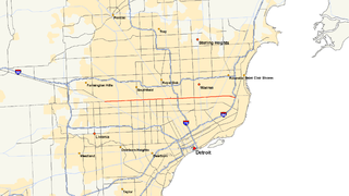
Interstate 696 (I-696) is an east–west auxiliary Interstate Highway in the US state of Michigan. The state trunkline highway is also known as the Walter P. Reuther Freeway, named for the prominent auto industry union head by the Michigan Legislature in 1971. I-696 is a bypass route, detouring around the city of Detroit through the city's northern suburbs in Oakland and Macomb counties. It starts by branching off I-96 and I-275 at its western terminus in Novi, and runs through suburbs including Southfield, Royal Oak and Warren before merging into I-94 at St. Clair Shores on the east end. It has eight lanes for most of its length and is approximately 10 miles (16 km) north of downtown Detroit. I-696 connects to other freeways such as I-75 and M-10. Local residents sometimes refer to I-696 as "The Autobahn of Detroit."

M-10 is a north–south state trunkline highway in the Metro Detroit area of Michigan in the United States. The southernmost portion follows Jefferson Avenue in downtown Detroit, and the southern terminus is at the intersection of Jefferson and M-3 next to the entrance to the Detroit–Windsor Tunnel. The northern terminus is in West Bloomfield Township at the intersection with Orchard Lake Road. The highway has several names as it runs through residential and commercial areas of the west side of Detroit and into the suburb of Southfield. It is called the John C. Lodge Freeway, The Lodge, James Couzens Highway and Northwestern Highway.

M-15 is a north–south state trunkline highway in the US state of Michigan. The southern terminus is a junction with US Highway 24 (US 24) just south of Clarkston on the northwestern edge of the Detroit metropolitan area. The trunkline is a recreational route running north and northwest to the Tri-Cities area. The northern terminus is the junction with M-25 on the east side of Bay City. The total length is about 73 2⁄3 miles (118.6 km) between the two regions.
M-102 is an east–west state trunkline highway in the US state of Michigan that runs along the northern boundary of Detroit following 8 Mile Road. The highway follows the Michigan Baseline, a part of the land survey of the state, and the roadway is also called Base Line Road in places. As a county road or city street, 8 Mile Road extends both east and west of the M-102 designation, which leaves 8 Mile on the eastern end to follow Vernier Road. The western terminus of M-102 is at the junction of 8 Mile Road and M-5 and the opposite end is at Vernier Road and Interstate 94 (I-94). The 8 Mile Road name extends west to Pontiac Trail near South Lyon with a discontinuous segment located west of US Highway 23 (US 23). The eastern end of 8 Mile Road is in Grosse Pointe Woods, near I-94, with a short, discontinuous segment east of Mack Avenue.
Interstate 275 (I-275) is an Interstate in the US state of Michigan that acts as a western bypass of the Detroit metropolitan area. The Michigan Department of Transportation (MDOT) maintains the highway as part of the larger state trunkline highway system. The freeway runs through the western suburbs near Detroit Metropolitan Wayne County Airport, and crosses several rivers and rail lines in the area. The southern terminus is the interchange with I-75 near Newport, northeast of Monroe. MDOT considers the Interstate to run to an interchange with I-96, I-696 and M-5 on the Farmington Hills–Novi city line, running concurrently with I-96 for about five miles (8.0 km). This gives a total length of about 35.03 miles (56.38 km), which is backed up by official signage. According to the Federal Highway Administration (FHWA), the length is 29.97 miles (48.23 km) because that agency considers I-275 to end at the junction with I-96 and M-14 along the boundary between Livonia and Plymouth Township. All other map makers, like the American Automobile Association, Rand McNally and Google Maps follow MDOT's practice.

M-53 is a north–south state trunkline highway in the US state of Michigan that connects Detroit to The Thumb region. The highway starts in Detroit at a connection with M-3 and ends in Port Austin, Michigan at M-25. In between, the trunkline passes through the northern suburbs of Metro Detroit, connects to freeways like Interstate 69 (I-69) and provides access to rural farmland. In Macomb County, M-53 follows the Christopher Columbus Freeway, while the remainder of the highway is known as Van Dyke Avenue in the metro area or Van Dyke Road elsewhere. The highway has also been named the Earle Memorial Highway for one of the pioneers of the Good Roads Movement and Michigan's highway system.

M-153 is a state trunkline highway in the Metro Detroit area of the US state of Michigan. It is also known as Ford Road for nearly its entire length, except for its westernmost portion where the highway follows a short expressway to M-14. Named for William Ford, father of Henry Ford, Ford Road runs from near Dixboro to the Dearborn–Detroit border. The M-153 designation continues along Wyoming Avenue where it terminates at a junction with Interstate 94 (I-94) and US Highway 12 (US 12) on the city line.

M-39 is a 16 miles (26 km) long north–south state trunkline highway in Metro Detroit area of the US state of Michigan that runs from Lincoln Park, on the south end, to Southfield on the north. The official southern terminus of M-39 is at the corner of Southfield Road and Lafayette Boulevard in Lincoln Park, one block southeast of the junction of Interstate 75 and two blocks northwest of M-85. From there the highway heads northward. The first 2.3 miles (3.7 km) of the highway follows Southfield Road, a divided highway in the Downriver area. It then transitions into the Southfield Freeway, which is a 13.7 miles (22.0 km) long freeway that runs from Allen Park north through Dearborn, and then the west side of Detroit, to Southfield. The northern terminus is at M-10 in Southfield.

M-97 is a state trunkline highway in the U.S. state of Michigan. It runs from Detroit to north of Mt. Clemens following Groesbeck Highway. The highway starts south of 7 Mile Road and runs northeasterly through Macomb County suburbs to Hall Road, which takes the place of 20 Mile Road in the Mile Road System. In between the termini, Groesbeck Highway runs through suburban residential and commercial areas.

Outer Drive is a bypass road which encircles both the eastern and western portions of the Detroit, Michigan region. It resembles a jagged horseshoe and was not originally intended to move traffic as much as it was to provide a pleasurable drive around the City of Detroit and some of its suburbs.
Interstate 94 (I-94) is a part of the Interstate Highway System that runs from Billings, Montana, to the Lower Peninsula of the US state of Michigan. In Michigan, it is a state trunkline highway that enters the state south of New Buffalo and runs eastward through several metropolitan areas in the southern section of the state. The highway serves Benton Harbor–St. Joseph near Lake Michigan before turning inland toward Kalamazoo and Battle Creek on the west side of the peninsula. Heading farther east, I-94 passes through rural areas in the middle of the southern Lower Peninsula, crossing I-69 in the process. I-94 then runs through Jackson, Ann Arbor, and portions of Metro Detroit, connecting Michigan's largest city to its main airport. Past the east side of Detroit, the Interstate angles northeasterly through farmlands in The Thumb to Port Huron, where the designation terminates on the Blue Water Bridge at the Canadian border.

The Philetus W. Norris House is located at 17815 Mt. Elliott Avenue in Detroit, Michigan, near the corner of Mound Road and Davison Avenue. It was built in 1873 by Philetus W. Norris, who went on to become the second superintendent of Yellowstone National Park. The house was listed on the National Register of Historic Places in 1992 but destroyed in 2016.
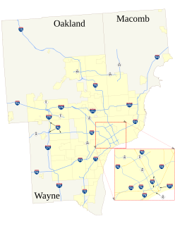
The roads and freeways in metropolitan Detroit comprise the main thoroughfares in the region. The freeways consist of an advanced network of interconnecting freeways which include Interstate highways. The Metro Detroit region's extensive toll-free freeway system, together with its status as a major port city, provide advantages to its location as a global business center. There are no toll roads in Michigan.


