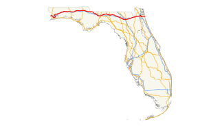
| Length | 10.76 mi [1] (17.32 km) |
|---|---|
| South end | Brest Street in Lincoln Park-Southgate |
| Major junctions | |
| East end | Iroquois Street in Detroit |
Lafayette Boulevard (also referred to as Lafayette Street and Lafayette Avenue) is a major east-west street through the city of Detroit, extending from the southeast side through downtown into the southwest side, ending at Woodmere Cemetery. Lafayette Boulevard, like certain other east-west streets that had ended in southwest Detroit east of Woodmere Cemetery, reappears in the suburb of Lincoln Park, Michigan. The stretch through downtown Detroit is lined with structures including the Detroit Free Press Building and Greektown Casino Hotel.

Detroit is the largest and most populous city in the U.S. state of Michigan, the largest United States city on the United States–Canada border, and the seat of Wayne County. The municipality of Detroit had a 2017 estimated population of 673,104, making it the 23rd-most populous city in the United States. The metropolitan area, known as Metro Detroit, is home to 4.3 million people, making it the second-largest in the Midwest after the Chicago metropolitan area. Regarded as a major cultural center, Detroit is known for its contributions to music and as a repository for art, architecture and design.

Lincoln Park is a city in Wayne County in the U.S. state of Michigan. It lies in an area of cities and communities known as Downriver. The population was 38,144 at the 2010 census. The settlement was organized as a village in 1921, and reorganized as a city in 1925. The area was originally home to the Potawatomi Indians who ceded the land to a French settler, Pierre St. Cosme, in 1776. It developed as a bedroom community, providing homes to workers in the nearby steel mills and automobile plants of the Detroit area while having no industry within its bounds.

Downtown Detroit is the central business district and a residential area of the city of Detroit, Michigan, United States. Detroit is the major city in the larger Metro Detroit region. Downtown Detroit is bordered by M-10 to the west, Interstate 75 to the north, I-375 to the east, and the Detroit River to the south. The city's main thoroughfare M-1 links Downtown to Midtown, New Center, and the North End.
This list below shows the information on the buildings located along Lafayette Boulevard in the city of Detroit.
| Address | Building Name | Building use | Year Built | Architectural Style | Floors | Notes | |||
|---|---|---|---|---|---|---|---|---|---|
| South side of street | North side of street | ||||||||
| Outer Drive | |||||||||
| Woodmere Street | |||||||||
| Springwells Street | |||||||||
| Central Street | |||||||||
| Green Street | |||||||||
| Waterman Street | |||||||||
| Livernois Avenue | |||||||||
| Dragoon Street | |||||||||
| Junction Street | |||||||||
| Clark Street | |||||||||
| Fairbanks Street | |||||||||
| 4020 West Lafayette Boulevard | Hotel Yorba | hotel | 1923 [2] | 4 | |||||
| Hubbard Street | |||||||||
| West Grand Boulevard | |||||||||
| Fisher Freeway (Interstate 75) | |||||||||
| Ambassador Bridge | |||||||||
| Rosa Parks Boulevard | |||||||||
| Trumbull Street | |||||||||
| Lodge Freeway (M-10) | |||||||||
| 3rd Street | |||||||||
| 615 West Lafayette Boulevard | Detroit News Building | office building | 1917 | Romanesque | 3 | Houses the main offices of The Detroit News and Detroit Free Press | |||
| 2nd Street | |||||||||
| 550 West Lafayette Boulevard | WDIV Studios | television studio | 1 | Houses the main studios of WDIV-TV. | |||||
| 525 West Lafayette Boulevard | Fort Shelby Hotel | hotel | 1916 | Classical Revival, Georgian Eclectic, Beaux-Arts | 23 | Expanded 1927, reopened 2008 as the DoubleTree Suites by Hilton Hotel Detroit Downtown - Fort Shelby | |||
| 1st Street | |||||||||
| 411 West Lafayette Boulevard | 411 Building | office building | Houses Comerica Bank's Detroit offices. | ||||||
| Cass Avenue | |||||||||
| 321 West Lafayette Boulevard | Detroit Free Press Building | office building | 1925 | Art Deco | 16 | former Detroit Free Press headquarters | |||
| Washington Boulevard | |||||||||
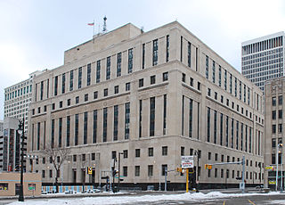
| 231 West Lafayette Boulevard | Theodore Levin United States Courthouse | courthouse | 1934 | 10 | |||||
| Shelby Street | |||||||||
| 144 West Lafayette Boulevard | Lafayette Building | office building | 1923 | neo-classical architecture | 14 | demolished 2010 | |||
| 751 Griswold Street | The Olde Building | lofts, restaurant | 1927 | neo-classical architecture | 4 | designed by Albert Kahn and Corrado Parducci | |||
| Griswold Street | |||||||||
| Michigan Avenue | |||||||||
| Randolph Street | |||||||||
| Brush Street | |||||||||
| 1000 Brush Street | Atheneum Suite Hotel Detroit | hotel | 8 | ||||||
| Beaubien Street | |||||||||
| 555 East Lafayette Boulevard | Greektown Casino Hotel | casino, hotel | 2000 | 30 | expanded 2008 | ||||
| Saint Antoine Street | |||||||||
| Chrysler Freeway (Interstate 375) | |||||||||
| Rivard Street | |||||||||
| 1300 East Lafayette Boulevard | 1300 Lafayette East Cooperative | housing cooperative | 1961 | 29 | |||||
| Orleans Street | |||||||||
| Dequindre Cut Greenway | |||||||||
| Saint Aubin Street | |||||||||
| Mount Elliott Street | |||||||||
| East Grand Boulevard | |||||||||
| Van Dyke Street | |||||||||
| Iroquois Street | |||||||||