Eureka Road

Last updated
Eureka Road
Eureka Road Wyandotte.jpg
Eureka Road in Wyandotte
Length13.21 mi [1] (21.26 km)
West endHuron River Drive in Romulus
Major
junctions
East end Detroit River in Wyandotte

Eureka Road (Eureka Avenue in Wyandotte) is a major east-west thoroughfare and section line road in the Downriver region of Metro Detroit in the U.S. state of Michigan. Although it is not a signed state trunkline, it is still a major roadway through the region.

Contents

Route description

Street sign for Eureka Road in Wyandotte Eureka street sign Wyandotte.jpg
Street sign for Eureka Road in Wyandotte

In Wyandotte, Eureka Avenue starts out as a residential street at the foot of the Detroit River, which runs west-northwestward. The avenue then intersects Biddle Avenue, and turns due west and widens to a major five-lane street with four through lanes and a left-turn lane in the center. Eureka passes by Roosevelt High School before sinking below ground level to accommodate five viaducts, all built in 1927: the four easternmost viaducts each carry Conrail Shared Assets/Norfolk Southern and Canadian National rail lines and the fifth is currently unused, but originally carried Detroit, Monroe & Toledo Short Line Railway interurban tracks [2] until that railroad folded in the early 1930s as a result of increasing competition from automobiles and intercity buses as well as the effects of the Great Depression.[ citation needed ]

Southgate Sign - Eureka Rd.jpg
The Eureka Road Entrance Signage for the Southgate Shopping Center, taken in February 2016.

Eureka Road crosses M-85 (Fort Street) into Southgate, where it forms the southern border of the Old Homestead subdivision. The road passes by Dunham's and Kroger(originally Downriver's first Kmart store), which closed in late 2016, stores, and neighboring Southgate Shopping Center, which includes Applebee's and Buffalo Wild Wings. After Trenton Road, the road continues on through more suburbs and commercial areas as the road continues west. West of Dix-Toledo Highway (formerly US-25), the area becomes increasingly commercial.

Eureka widens into a seven-lane road at Allen Road as it enters the city of Taylor before becoming a six-lane divided highway as the road crosses under another Canadian National line. The road then passes by a Denny's, Golden Corral, Bob Evan's, Super 8 hotel, and one of the tallest office buildings in Downriver as it approaches the I-75 interchange. West of the interchange and south of Eureka is the original location of the Gibraltar Trade Center, which closed its doors in November 2014 and was demolished in September 2015 for a Menards store, which is planning to open in 2017. A Costco store is also rumored to build on the former Gibraltar Trade Center site along with Menard's, but the future is not yet known. The road then crosses under another Conrail Shared Assets railroad line and crosses over the Frank & Poet drain before transitioning back into a seven-lane road at Racho Road. Eureka then passes the Kohl's-anchored Cross Creek Plaza and neighboring Southland Center, which includes a Best Buy storefront, and continues past several other businesses including Meijer, PetSmart, Panera Bread (previously co-located with Southgate Buffalo Wild Wings), McDonald's, Party City, and Wendy's.

In Romulus, Eureka continues west as the suburban sprawl on both sides of the road significantly decreases. The suburban sprawl stops completely east of Merriman Road as Eureka curves southwest and becomes a four-lane divided highway. The road then curves northwest as it approaches John Dingell Drive, which is the entrance to Detroit Metro Airport. Eureka transitions back into a five-lane road east of the Wayne Road/Wahrman Road intersection and I-275. Immediately after the Interstate 275 interchange, Eureka Road becomes a two-lane road as it approaches a CSX Transportation crossing and continues for a half-mile before ending at a stop sign and flashing red light at Huron River Drive.

Expressway portion

Eureka Road becomes an expressway from just west of Merriman Road to just west of Wayne Road along the southern edge of Metro Airport in Romulus. This includes a trumpet interchange with John D. Dingell Drive, which is Metro Airport's southern entrance, providing access to the airport's McNamara Terminal. Eureka Road was first converted to an expressway at this point in the early 1990s and was extended a 14 mile (0.40 km) east from its original terminus halfway between Merriman Road and Dingell Drive in late 2002.[ citation needed ]

Speed Limits

Currently, the speed limit on Eureka Road is 30 miles per hour (48 km/h) between Biddle Avenue and the railroad viaducts, 35 miles per hour (56 km/h) from the viaducts to Dix-Toledo Road, and 45 miles per hour (72 km/h) from Dix-Toledo westward. On September 6, 2015, The News-Herald announced that the speed limits on Eureka Road would increase by values of five. By the end of September 2015, the speed limit is expected to be changed to 35 miles per hour (56 km/h), 40 miles per hour (64 km/h) and 50 miles per hour (80 km/h) respectively.

2019 Resurfacing Project

In February 2018, Southgate Mayor Joseph Kuspa announced a resurfacing project for Eureka Rd. that stretches from Fort Street to Dix-Toledo roads. The project itself will be led by Wayne County, Michigan and will cost around $2.2 million. This project alone will also be the largest on the rolls for the county that year. [3]

Name

Eureka Road took its name from the Eureka Iron Company, whose plant was located at the foot of the road at the Detroit River in Wyandotte in the late 19th century. The Eureka Iron Company used this road to ship supplies to the plant. [4]

Public transportation

Eureka Road is served by portions of a total of three Suburban Mobility Authority for Regional Transportation routes, all serving Southland Center: Route 125 provides half-hour service between M-85 (Fort Street) and Metro Airport seven days a week, Route 160 provides hourly service six days a week between Trenton Road in Southgate and Biddle Avenue in downtown Wyandotte and Route 275 provides weekday rush-hour express service along Eureka between Southland Center and U.S. Highway 24 (Telegraph Road) in Taylor.

See also

Related Research Articles

Wyandotte, Michigan City in Michigan

Wyandotte is a city in Wayne County in the U.S. state of Michigan. The population was 25,883 at the 2010 census, a decrease of 7.6% from 2000. Wyandotte is located in southeastern Michigan, approximately 11 miles (18 km) south of Detroit on the Detroit River, and is part of the collection of communities known as Downriver. Wyandotte is bounded by Southgate (west), Lincoln Park (northwest), Riverview (south), Ecorse (north) and Lasalle (east).

Wayne County, Michigan County in Michigan

Wayne County is the most populous county in the U.S. state of Michigan. As of 2018, the United States Census estimated its population as 1,753,893 making it the 19th-most populous county in the United States. The county seat is Detroit, the largest and most populous city in Michigan and 23rd-most populous city in the United States. The county was founded in 1796 and organized in 1815.

Riverview, Michigan City in Michigan

Riverview is a city in Wayne County, Michigan. The population was 12,486 at the time of the 2010 census.

Southgate, Michigan City in Michigan

Southgate is a city in central Wayne County, Michigan, United States. The population was 30,047 at the 2010 census.

Taylor, Michigan City in Michigan

Taylor is a city in Wayne County in the U.S. state of Michigan. Its population was 63,131 at the 2010 census. Originally known as Taylor Township, its residents voted to incorporate it as the City of Taylor in May 1968. It is the 17th most populous city in Michigan and the 543rd in the United States.

Transportation in Seattle

Transportation in Seattle is largely focused on the automobile much like many other cities in western North America; however Seattle is just old enough that its layout reflects the age when railways and trolleys predominated. These older modes of transportation were made for a relatively well-defined downtown area and strong neighborhoods at the end of several former streetcar lines, now mostly bus lines.

Jefferson Avenue is a 63.71-mile-long (102.53 km) scenic road along the eastern part of the Detroit metropolitan area in the southeastern part of the U.S. state of Michigan. It travels alongside Lake Erie, the Detroit River, and Lake St. Clair. This road also provides access to many recreational facilities in the area. West Jefferson Avenue is primarily a commercial, while East Jefferson Avenue contains a historic residential district.

Downriver Metro Detroit in Michigan, United States

Downriver is the unofficial name for a collection of 18 cities and townships in Wayne County, Michigan, south of Detroit, along the western shore of the Detroit River.

M-85, also known as Fort Street or Fort Road for its entire length, is a state trunkline highway in the U.S. state of Michigan. The highway serves several Downriver suburbs of Detroit, as well as neighborhoods in the city itself. From its southern terminus at exit 28 on Interstate 75 (I-75) to its second interchange with exit 43 on I-75 in southwest Detroit, M-85 is part of the Lake Erie Circle Tour. In between, it serves mostly residential areas running parallel to a pair of rail lines; the highway carries between 5,000 and 43,000 vehicles per day on average. Once in the city of Detroit, Fort Street runs parallel to I-75 for several miles before they separate near the Ambassador Bridge. The northern end of M-85 is at the intersection with Griswold Street in downtown Detroit, one block away from Campus Martius Park.

US Highway 24 is a United States Numbered Highway that runs from Minturn, Colorado, to Independence Township, Michigan. In Michigan, it is also known as Telegraph Road and runs for 79.828 miles (128.471 km) as a major north–south state trunkline highway from Bedford Township at the Ohio state line through Metro Detroit. The highway runs through three counties in southeastern Michigan, Monroe, Wayne and Oakland, as it parallels the Lake Erie shoreline and bypasses Metro Detroit on the west. Telegraph Road connects several suburbs together and passes through the western edge of Detroit before it terminates northwest of Clarkston at an interchange with Interstate 75 (I-75).

Ohio State Route 795 highway in Ohio

State Route 795 is an east–west state highway in northwestern Ohio, a U.S. state. The western terminus of SR 795 is at US 20 in Perrysburg, at the signalized intersection that doubles as the northern terminus of SR 199. Its eastern terminus is at a signalized intersection with SR 51 about 0.5 miles (0.80 km) southeast of Millbury.

This article details the History of Wyandotte, Michigan. Wyandotte has a long history, dating back for hundreds of years.

John Biddle (Michigan politician) American military officer and politician

John Biddle was an American military officer, politician, and businessman. He served as a delegate to the United States Congress from the Michigan Territory, as the speaker of the Michigan House of Representatives, and as mayor of Detroit.

Suburban Mobility Authority for Regional Transportation public transit operator in suburban Metro Detroit, Michigan

The Suburban Mobility Authority for Regional Transportation (SMART) is the public transit operator serving suburban Metro Detroit. It partners with the Detroit Department of Transportation. Beginning operations in 1967 as the Southeastern Michigan Transportation Authority (SEMTA), it operates 44 linehaul and three park-and-ride bus routes in Wayne, Oakland and Macomb Counties. Its name was changed to SMART in 1989. As of 2008, SMART has the third highest ridership of Michigan's transit systems, surpassed by Capital Area Transportation Authority and Detroit Department of Transportation. SMART has its headquarters in the Buhl Building in Downtown Detroit.

Southgate Shopping Center

Southgate Shopping Center is a shopping center located at the southeast corner of Eureka and Trenton Roads in Southgate, Michigan. Completed by 1958, it was one of the first major strip malls in the southern Detroit suburbs until the nearby Southland Center opened in 1970. At its peak, the center housed over thirty stores.

Southland Center (Michigan) shopping center in Taylor, Michigan

Southland Center is an enclosed mall located at 23000 Eureka Road in Taylor, Michigan, exactly halfway between U.S. Highway 24 and the Interstate 75 freeway, presently anchored by Macy's, JCPenney, Best Buy, Shoe Carnival, Forever 21, Ulta Beauty, H&M and a 12-screen Cinemark movie theater. It is the newest of the Detroit area's four "land" malls. Southland Center opened on July 20, 1970. It is owned and managed by Brookfield Properties Retail Group, one of the largest mall owners in the United States.

Roads and freeways in metropolitan Detroit list of roads in part of Michigan

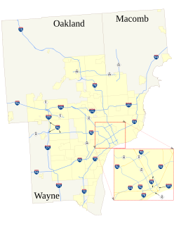
The roads and freeways in metropolitan Detroit comprise the main thoroughfares in the region. The freeways consist of an advanced network of interconnecting freeways which include Interstate highways. The Metro Detroit region's extensive toll-free freeway system, together with its status as a major port city, provide advantages to its location as a global business center. There are no toll roads in Michigan.

Trails in Detroit

This is a list of trails and greenways in Detroit.

Wyandotte Terminal Railroad was incorporated in the State of Michigan, United States of America, on September 14, 1904. It ceased operations as a railroad in 1982.

Old Homestead, Southgate, Michigan Place in Michigan, United States

Old Homestead is a neighborhood on the east side of the Metro Detroit suburb of Southgate, Michigan. Usually, Old Homestead is bordered by Superior Street to the north, Eureka Road to the south, M-85 to the east and either Trenton Road or Burns Street to the west. Commercial districts are located along Eureka Road and Fort Street and the rest of the neighborhood is mostly single-family homes, most of which were built during the 1940s and 1950s. The most common housing styles within Old Homestead consist of one-story ranch homes, one-and-a-half-story Cape Cods and two-story colonial revivals.

References

  1. Google Earth ruler path measurements
  2. "Passenger Railroads Used to Be Popular Downriver". The News-Herald . Southgate, MI. Retrieved July 1, 2014.
  3. Herndon, Dave. "Eureka Road repairs slated for 2019 in Southgate".
  4. Gavrilovich, Peter & McGraw, Bill (2000). The Detroit Almanac: 300 Years of Life in the Motor City. Detroit: Detroit Free Press. pp. 240–8. ISBN   978-0-937247-34-1.