
U.S. Route 101, or U.S. Highway 101 (US 101), is a north–south United States Numbered Highway that runs through the states of California, Oregon, and Washington, on the West Coast of the United States. It is also known as El Camino Real where its route along the southern and central California coast approximates the old trail which linked the Spanish missions, pueblos, and presidios. It merges at some points with California State Route 1 (SR 1).
Clallam County is a county in the U.S. state of Washington. As of the 2010 census, the population was 71,404. The county seat and largest city is Port Angeles; the county as a whole comprises the Port Angeles, WA Micropolitan Statistical Area. The name is a Klallam word for "the strong people". The county was formed on April 26, 1854. Located on the Olympic Peninsula, it is south from the Strait of Juan de Fuca, which forms the Canada–US border, as British Columbia's Vancouver Island is across the strait.

Bell Hill is an unincorporated community and census-designated place (CDP) in Clallam County, Washington, United States. The population was 837 at the 2010 census, up from 731 at the 2000 census. Located just south of the city of Sequim, Bell Hill has become a fast-growing destination for the very wealthy, with a high population of Californians who found success in high tech businesses. Although Sequim is not affluent, it is known for its low levels of rain, a quality that has made Bell Hill very attractive. Bell Hill gets somewhat more precipitation than Sequim but is drier than most western Washington areas.

Blyn is a census-designated place (CDP) in Clallam County, Washington, United States. The population was 101 at the 2010 census, down from 162 at the 2000 census. It is located near the city of Sequim on the shores of Sequim Bay. The area includes the Jamestown S'Klallam Indian Reservation, established in 1874 by the Jamestown S'Klallam Tribe, who named the community Jamestown.

Carlsborg is an unincorporated community and census-designated place (CDP) in Clallam County, Washington, United States. The population was 995 at the 2010 census, up from 855 at the 2000 census.

Port Angeles East is a census-designated place (CDP) in Clallam County, Washington, United States. The population was 3,036 at the 2010 census. This unincorporated urban growth area bordering the city of Port Angeles is known by locals as the Gales Addition.

River Road is a census-designated place (CDP) in Clallam County, Washington, United States. The population was 454 at the 2010 census. It is a primarily residential area next to the city of Sequim.

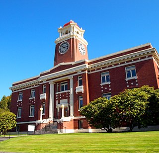
Sequim is a city in Clallam County, Washington, United States. It is located along the Dungeness River near the base of the Olympic Mountains. The 2010 census counted a population of 6,606.

Seymour is a census-designated place (CDP) and unincorporated community in Blount and Sevier counties in the U.S. state of Tennessee. The CDP population was 10,919 at the 2010 U.S. census. It is included in the Knoxville, Tennessee Metropolitan Statistical Area.

Bayview is an unincorporated community centered at the intersection of State Route 525 and Bayview Road on Whidbey Island in Island County, Washington, United States.

The Olympic Peninsula is a large arm of land in western Washington that lies across Puget Sound from Seattle, and contains Olympic National Park. It is bounded on the west by the Pacific Ocean, the north by the Strait of Juan de Fuca, and the east by Hood Canal. Cape Alava, the westernmost point in the contiguous United States, and Cape Flattery, the northwesternmost point, are on the peninsula. Comprising about 3,600 square miles (9,300 km2), the Olympic Peninsula contained many of the last unexplored places in the contiguous United States. It remained largely unmapped until Arthur Dodwell and Theodore Rixon mapped most of its topography and timber resources between 1898 and 1900.

The Alsea River flows 48.5 miles (78.1 km) from Alsea, an unincorporated community in the coastal mountains of the U.S. state of Oregon, to the Pacific Ocean near the city of Waldport. It begins at the confluence of the North Fork Alsea River and the South Fork Alsea River and ends in Alsea Bay, a wide estuary at Waldport. The river flows generally west-northwest in a winding course through the mountains of southern Benton and Lincoln counties, passing near the unincorporated community of Tidewater and through the Siuslaw National Forest. Its drainage basin extends into Lane County, along the headwaters of the South Fork Alsea River.

Discovery Bay is a small bay connected to the Strait of Juan de Fuca on the Olympic Peninsula in Washington state; it was also historically called Port Discovery. An unincorporated community also named Discovery Bay lies in Jefferson County at the southern end of the bay.

Gardiner is an unincorporated community in Jefferson County, Washington, United States.

The SequimMuseum & Arts, located in downtown Sequim, Washington, is a free-admission local history museum. Founded in 1976, the museum is home to the Manis Mastodon tusks and bones which were found at an early human encampment located on the present day Manis Farm, famous as one of the first-known contact between humans with a mastodon 13,000 years ago.
Sequim Bay is a bay in northwestern Washington, on the Olympic Peninsula. The bay is on the Strait of Juan de Fuca of the Pacific Ocean and is located east of Sequim, Washington and north of Blyn. Sequim Bay is about 2 miles (3.2 km) long and slightly over 1 mile (1.6 km) wide at the mouth.
U.S. Route 101 (US 101) is a United States Numbered Highway that runs along the Pacific Coast from Los Angeles, California to Tumwater, Washington. Within the state of Washington, US 101 connects cities on the coast of the Pacific Ocean and encircles the Olympic Peninsula around the Olympic Mountains and Olympic National Park.
Oak Point, also known as Oakpoint, is an unincorporated community in Cowlitz County, Washington. Oak Point is located northwest of the city of Longview, reached by traveling westbound out of the city along Washington State Route 4, also known as Ocean Beach Highway, and turning north onto Mill Creek Road. The Oak Point community is part of the Longview School District, a K-12 school district of about 6,600 students.
The Moclips Highway is a two-lane highway in the U.S. state of Washington. It goes about 22 miles (35 km) from Moclips on the Pacific Ocean, through the Quinault Indian Reservation, to U.S. Highway 101.

