
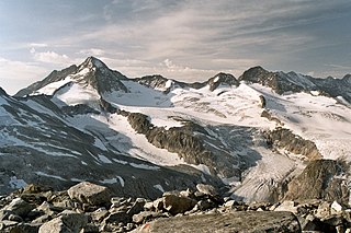
Wildspitze is the highest mountain in the Ötztal Alps and in North Tyrol, as well as the second highest mountain in Austria after the Großglockner and in terms of prominence is the fourth summit of the Alps and the fifteenth of Europe.

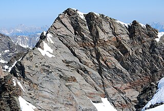
The Großglockner, or just Glockner, is, at 3,798 metres above the Adriatic (12,461 ft), the highest mountain in Austria and highest mountain in the Alps east of the Brenner Pass. It is part of the larger Glockner Group of the Hohe Tauern range, situated along the main ridge of the Central Eastern Alps and the Alpine divide. The Pasterze, Austria's most extended glacier, lies on the Grossglockner's eastern slope.

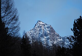
Ortler is, at 3,905 m (12,812 ft) above sea level, the highest mountain in the Eastern Alps outside the Bernina Range. It is the main peak of the Ortler Range. It is the highest point of the Southern Limestone Alps, of South Tyrol in Italy, of Tyrol overall, and, until 1919, of the Austrian-Hungarian empire. In German the mountain is commonly referred to as "König Ortler", like in the unofficial hymn of South Tyrol, the Bozner Bergsteigerlied.

The Großes Wiesbachhorn is a mountain in the federal state of Salzburg, Austria and, at 3,564 m above sea level (AA), is the third-highest peak of the Hohe Tauern range.

The Dreiherrnspitze, at 3,499 m (11,480 ft) above mean sea level, is a mountain on the tripoint between the Austrian states of Salzburg and Tyrol, and South Tyrol in Italy. It is part of the Venediger Group in the Hohe Tauern range of the Central Eastern Alps and the Alpine divide.
The Eiskögele is a 3,426-metre-high (11,240 ft) mountain in the Glockner Group in the western part of the main Tauern chain, a range of the Austrian Central Alps. It lies right on the border between the Austrian states of Salzburg, Carinthia and East Tyrol and thus forms a tripoint. The mountain has the shape of an ice-covered horn with a mighty North Face, a prominent Northeast Ridge (Nordostgrat) and a sharp firn edge (Firnschneide) to the west. From its base, the Oberwalder Hut, it is easy to reach via the Pasterzeboden glacier. It was first climbed on 30 July 1872 by the tourist B. Lergetporer from Schwaz and mountain guides, Michel Groder and Josef Kerer. The first solo ascent of the mountain was achieved in August 1891 by Ludwig Kohn from Vienna as part of a crossing from the Schneewinkelkopf.

The Fuscherkarkopf, sometimes also written Fuscher-Kar-Kopf in German and formerly also called the Fuschereiskarkopf, is one of the twin peaks of a mountain in the Glockner Group in the centre of the main mountain chain in the High Tauern, a range in the Austrian Central Alps. The mountain lies right on the border between the Austrian states of Salzburg and Carinthia. The main peak is 3,331 metres high, but the northwest summit is only 3,252 metres high. The two peaks are about 500 metres apart and linked by a curved firn-covered ridge. Further sharp, prominent ridges run away to the northwest and west, forming the main crest of the Tauern. To the southwest the Heiligenblut Open Face branches off, a mighty side ridge that starts as the southeast ridge (Südostgrat) at the Fuscherkarkopf. The northwest summit has a great, 650-metre-high (2,130 ft) West Face (Westwand), that used to be covered with firn, but today is covered with loose rock slabs. The mountain is easy to reach from the Hofmanns Hut over the southwest ridge (Südwestgrat) and offers a good view of the Großglockner and the Pasterze. The peak was first climbed in the 1840s by the hunter, Gregor Maier, known as Badhans, from Fusch.
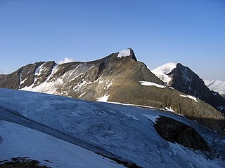
The Hinterer Bratschenkopf is a mountain in the Glockner Group on the Fusch-Kaprun ridge in the High Tauern, a high mountain range in the Austrian Central Alps. According to the listed sources it is 3,412 metres high, but the Austrian Federal Office for Metrology and Survey gives its height as 3,413 metres. The mountain lies in the Austrian state of Salzburg. It appears from the north, east and south as a gently curved firn summit, but from the west it has a mighty, 1,400-metre-high (4,600 ft) and 40 to 60° rock face. A steep, 500-metre-long (1,600 ft) knife-edge ridge bears away from the mountaintop to the north. Due to its close proximity to the Heinrich Schwaiger Haus, the summit is a popular viewing point. The peak was first climbed on 18 September 1869 by the Munich Alpinist, Karl Hofmann, the Prague businessman, Johann Stüdl, and mountain guides Thomas Groder and Josef Schnell from Kals am Großglockner.

The Olperer is a 3,476-metre-high (11,404 ft) mountain in the Zillertal Alps in the Austrian federal state of Tyrol. It is the main summit on the Tux Crest and is often crossed in the summer as climbers transit from the Olperer Hut to the Geraer Hut. It was first climbed on 10 September 1867 along the southeast ridge (Südostgrat) by Paul Grohmann, Georg Samer and Gainer Jackl. On its north flank is the ski region known as Hintertux Glacier on the Gefrorene-Wand-Kees glacier.
The Strahlkogel, at 3,288 m (AA), is the highest peak in the Larstiger Mountains, a subgroup of the Stubai Alps in the Austrian state of Tyrol. The Strahlkogel is also the highest mountain in the municipality of Umhausen. Its name comes from its great, white, light-reflecting, quartz layers, which allegedly cause the mountain to "radiate" (strahlen). It has the shape of a well-proportioned, steep and pointed pyramid. Ascending the Strahlkogel is difficult and it is thus only rarely visited, unlike the neighbouring 3,287-metre-high Breiter Grieskogel. The first ascent of the mountain was in 1833 by Peter Carl Thurwieser, but his route and the precise circumstances of the climb have not been passed on. On 28 August 1887 Ludwig Purtscheller and Fritz Drasch from Salzburg climbed the mountain. Their route led along the west arête. Today, this is the normal route and easiest way to reach the summit.

The Hoher Eichham, at 3,371 m (AA), is the most dominant mountain in the southeastern part of the Venediger Group in the High Tauern in Austria. Four arêtes radiate from its summit towards the north, east, south and southwest. To the southeast is the glacier of Nilkees and, to the northeast, is the Hexenkees. The Großer Eichhamkees to the northwest and the Kleiner Eichhamkees to the southwest have shrunk to insignificant slabs of ice. On the North Arête is a rock tower, the Eichhamturm. Along the continuation of the arête lies the Großer Hexenkopf, which is roughly 600 metres as the crow flies from the Hoher Eichham. On the East Arête is the Niederer Eichham. From this subpeak a ridge branches southeast linking it with the Sailkopf; the lowest notch on this arête being the Sailscharte. The Hoher Eichham may have first been climbed during a military survey using triangulation in the 1850s. The first visit to the summit by tourists was on 16 July 1887 by Berlin alpinists, Carl Benzien and Hermann Meynow using the South Arête. They were led by the Zillertal mountain guide, Hans Hörhager, from Dornauberg.

The Große Möseler, also called the Mösele, is a mountain, 3,480 m (AA), and thus the second highest peak in the Zillertal Alps after the Hochfeiler (3,509 m). It lies on the Zillertal main ridge which forms the border here between the Austrian state of Tyrol and the Italian province of South Tyrol. Its great size makes it the dominant mountain in the area. Seen from the northwest it appears like a firn-covered dome; but from the northeast as a regularly shaped cone of rock. Prominent arêtes radiate from the peak to the northwest, east and south. The mountain is easily ascended from the Furtschaglhaus and is often visited as a result. It was first climbed on 16 June 1865 by G. H. Fox, Douglas William Freshfield and Francis Fox Tuckett with mountain guides, François Devouassoud from Chamonix and Peter Michel from Grindelwald, as well as two unknown bearers.

At 3,474 m (AA) the Ruderhofspitze is the fourth highest mountain in the Stubai Alps in Austria. It is part of the Alpein Mountains and lies in the Austrian state of Tyrol. As a result of its topographic isolation and good all-round views it is one of the most visited mountains in the Stubai. An almost two-kilometre-long arête, the Grawawand, runs away from the summit to the east. Less prominent ridges run south and northwestwards from the Ruderhofspitze. The peak was first ascended on 30 August 1864 by Karl Baedeker, Anton von Ruthner and mountain guides Pankraz Gleinser and Alois Tanzer.

The Große Bärenkopf or Weißer Bärenkopf is a twin-topped mountain in the Glockner Group in the Fuscher/Kapruner Kamm of the High Tauern, a range in the Austrian Central Alps. The mountain lies exactly on the border between the states of Salzburg and Carinthia.
The Großer Geiger, formerly also called the Obersulzbacher Venediger and Heiliggeistkogel, is a mountain, 3,360 m (AA), in the Venediger Group in the main chain of the Central Tauern. This chain lies in the High Tauern, part of the Austrian Central Alps on the border between the Austrian states of Tyrol in the south and Salzburg in the north.

The Schlieferspitze is a mountain, 3,290 m (AA), on the ridge known as the Krimmler Kamm in the Venediger Group of the Alps. The ridge lies in the northwest of the High Tauern, part of the Austrian Central Alps in the Austrian federal state of Salzburg. The summit is the highest on the Krimmler Kamm and is described in the sources as one of the most attractive peaks in the Venediger Group. From the valleys of the Krimmler Achental to the southwest and the Obersulzbachtal to the northeast it appears as an extremely dominant mountain. Long and evenly formed arêtes, about two kilometres long, run from the summit to the northwest, northeast, southeast and southwest. The mountain was first ascended on 22 August 1871 by Eduard Richter, professor of geography at the University of Graz, and Johann Stüdl, a merchant from Prague and co-founder of the German Alpine Club.
The Gleirscher Fernerkogel, also Gleirschfernerkogl, formerly called the Roßkarspitze, is a mountain, 3,189 m (AA), in the Southern Sellrain Mountains, a subgroup of the Stubai Alps. It rises in the Austrian state of Tyrol. The old name, Roßkarspitze, was given to it during the military survey of the region in the 1850s. The first documented ascent was undertaken on 1 September 1883 by Ludwig Purtscheller and Hans Schöller, a "professor from Salzburg". Purtscheller gave the mountain its present name. A prominent 500-metre-long ridge runs eastwards from the unimposing summit.
The Jochköpfl is a mountain, 3,143 m (AA), on the Windach-Brunnenkogel-Kamm, a subgroup of the Stubai Alps in Austria.

The Wildkarspitze is a mountain, 3,073 m (AA), in the Zillertal Alps in the Austrian state of Salzburg.

The Stubaier Wildspitze is a 3,341-metre-high mountain in the Stubai Alps in the Austrian state of Tyrol. Northeast of the summit lie two glaciers, the Schaufelferner and the Daunkogelferner, which form the basis for the Stubai Glacier ski region.


