Mayrhofen

Last updated
Mayrhofen
Mayrhofen.jpg
Wappen at mayrhofen.png
Austria adm location map.svg
Red pog.svg
Mayrhofen
Location within Austria
Coordinates: 47°10′N11°52′E / 47.167°N 11.867°E / 47.167; 11.867
Country Austria
State Tyrol
District Schwaz
Government
   Mayor Monika Wechselberger
Area
[1]
  Total178.79 km2 (69.03 sq mi)
Elevation
633 m (2,077 ft)
Population
 (2018-01-01) [2]
  Total3,858
  Density22/km2 (56/sq mi)
Time zone UTC+1 (CET)
  Summer (DST) UTC+2 (CEST)
Postal code
6290
Area code 05285
Vehicle registration SZ
Website www.mayrhofen.at

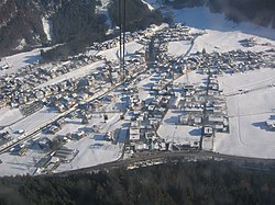
Mayrhofen is a town in the Zillertal (Ziller river valley) in the Austrian state of Tyrol. It is located approximately an hour from the Tyrolean capital city of Innsbruck.

Contents

Population

Historical population
YearPop.±%
18691,172    
18801,114−4.9%
18901,094−1.8%
19001,096+0.2%
19101,218+11.1%
19231,514+24.3%
19341,928+27.3%
19392,076+7.7%
19512,351+13.2%
19612,523+7.3%
19713,175+25.8%
19813,270+3.0%
19913,679+12.5%
20013,751+2.0%
20113,833+2.2%

Tourism

The town offers a variety of summer and winter sports including skiing, hiking, mountain biking and paragliding. Mayrhofen is situated near the Hintertux glacier, which, at 3,250 metres (10,660 feet) above sea level, is above the snowline. [3] Skiing is available all year round here. Mayrhofen sits between the Penken and the Ahorn mountains which provide ski runs in the winter and mountain biking, hiking and paragliding in the summer. The Ahorn offers mainly easy and intermediate runs, but also has a long, steep black run (formerly red) which was once on the World Cup Downhill circuit but was removed as it was deemed too dangerous. The Penken mountain offers Austria's steepest piste, named Harakiri, as well as a large range of ski runs at different levels of difficulty. It is connected by lifts with the villages of Finkenberg, Lanersbach and Schwendau.

Tricable detachable gondola lift Penkenbahn and its stations

The Penken is reached by a Gondola system, the Penkenbahn  [ de ], which is located on the main street next to the Sport Hotel Strass, in the centre of the village, while the Ahorn Cable car or Ahornbahn  [ de ], which with a capacity of 160 passengers is the largest cable car in Austria, [4] is situated at the southern end of the town. Mayrhofen is a snowboard-minded village with a funpark sponsored by Vans, and the snowboardhotel Gasthof Zillertal owned by the Dutch organisation 'SAIKO expeditions'. Mountaineer Peter Habeler and Downhill Racer Uli Spiess both come from Mayrhofen. [5] [6]

The town also provides an excellent base for walkers, as Mayrhofen is home to many trails touring the mountains and nearby Ziller valley. [7]

Events

Each spring (usually early April), Mayrhofen hosts the Snowbombing music festival. Since the initial event in 2000 (held in Risoul, France), snowbombing has gathered much notoriety and respect in the electronic dance music world as one of the major festivals. The event has been hosted by Mayrhofen since 2005. [8]

Snowbombing.jpg
Snowbombing piste-side music venue

Climate

Mayrhofen
Climate chart (explanation)
J
F
M
A
M
J
J
A
S
O
N
D
 
 
55
 
 
1
−4
 
 
46
 
 
4
−3
 
 
63
 
 
10
0
 
 
74
 
 
14
3
 
 
97
 
 
20
8
 
 
131
 
 
22
11
 
 
149
 
 
24
13
 
 
131
 
 
23
12
 
 
97
 
 
19
9
 
 
65
 
 
14
5
 
 
75
 
 
6
0
 
 
62
 
 
1
−3
Average max. and min. temperatures in °C
Precipitation totals in mm
Source: ZAMG
Imperial conversion
JFMAMJJASOND
 
 
2.2
 
 
34
25
 
 
1.8
 
 
39
27
 
 
2.5
 
 
50
32
 
 
2.9
 
 
57
37
 
 
3.8
 
 
68
46
 
 
5.2
 
 
72
52
 
 
5.9
 
 
75
55
 
 
5.2
 
 
73
54
 
 
3.8
 
 
66
48
 
 
2.6
 
 
57
41
 
 
3
 
 
43
32
 
 
2.4
 
 
34
27
Average max. and min. temperatures in °F
Precipitation totals in inches
Climate data for Mayrhofen (1971–2000)
MonthJanFebMarAprMayJunJulAugSepOctNovDecYear
Record high °C (°F)16.0
(60.8)
17.0
(62.6)
24.0
(75.2)
27.0
(80.6)
31.0
(87.8)
32.6
(90.7)
36.0
(96.8)
35.0
(95.0)
31.2
(88.2)
26.0
(78.8)
21.6
(70.9)
19.0
(66.2)
36.0
(96.8)
Average high °C (°F)1.1
(34.0)
4.3
(39.7)
9.6
(49.3)
14.1
(57.4)
19.7
(67.5)
21.7
(71.1)
23.8
(74.8)
23.2
(73.8)
19.3
(66.7)
13.9
(57.0)
6.0
(42.8)
1.4
(34.5)
13.2
(55.8)
Daily mean °C (°F)−2.1
(28.2)
−0.4
(31.3)
3.6
(38.5)
7.6
(45.7)
12.7
(54.9)
15.2
(59.4)
17.1
(62.8)
16.5
(61.7)
12.9
(55.2)
8.3
(46.9)
2.3
(36.1)
−1.3
(29.7)
7.7
(45.9)
Average low °C (°F)−4.4
(24.1)
−3.4
(25.9)
0.0
(32.0)
3.3
(37.9)
7.8
(46.0)
10.6
(51.1)
12.5
(54.5)
12.3
(54.1)
9.2
(48.6)
4.9
(40.8)
−0.1
(31.8)
−3.4
(25.9)
4.1
(39.4)
Record low °C (°F)−22.0
(−7.6)
−16.4
(2.5)
−16.2
(2.8)
−5.0
(23.0)
−4.0
(24.8)
1.8
(35.2)
1.0
(33.8)
4.0
(39.2)
0.0
(32.0)
−5.7
(21.7)
−13.2
(8.2)
−18.0
(−0.4)
−22.0
(−7.6)
Average precipitation mm (inches)54.7
(2.15)
46.4
(1.83)
63.2
(2.49)
74.0
(2.91)
96.9
(3.81)
130.9
(5.15)
148.9
(5.86)
130.7
(5.15)
97.0
(3.82)
64.7
(2.55)
74.6
(2.94)
61.7
(2.43)
1,043.7
(41.09)
Average snowfall cm (inches)28.0
(11.0)
25.3
(10.0)
16.4
(6.5)
4.5
(1.8)
0.4
(0.2)
0.0
(0.0)
0.0
(0.0)
0.0
(0.0)
0.0
(0.0)
0.8
(0.3)
10.2
(4.0)
20.8
(8.2)
106.4
(41.9)
Average precipitation days (≥ 1.0 mm)8.47.99.910.611.415.015.414.210.78.39.79.2130.7
Average relative humidity (%) (at 14:00)79.765.655.550.747.953.454.656.358.663.676.585.962.4
Mean monthly sunshine hours 2.469.0130.3124.1183.5164.4183.6176.9138.487.419.511.21,290.7
Source: Central Institute for Meteorology and Geodynamics [9]

Transport

The railway station at Mayrhofen im Zillertal. Zillertalbahn Bahnhof Mayrhofen 2010.jpg
The railway station at Mayrhofen im Zillertal.

Mayrhofen has one railway station, which is located next to the Zillertaler Bundestrasse. The station is a terminus for all Train services operated by the Zillertalbahn, the valley's main public transport operator. [10] The railway runs between Jenbach and Mayrhofen itself, and there are several intermediate stations, which provide access to many of the valley's well known ski areas, namely Zell am Ziller (Zillertal 3000), Fügen (Spieljoch) and Uderns (for the Hochfügen and Kaltenbach ski areas). The railway operates year-round, although in summer additional 'special' services operate, such as a steam train service.

The Zillertalbahn also run bus routes in the valley, which are regular and cover an extensive area. [11] Additional services also operate during the winter, to cater for the skiing season.

Statistics

Twin towns

Related Research Articles

<span class="mw-page-title-main">St Anton am Arlberg</span> Place in Tyrol, Austria

Sankt Anton am Arlberg, commonly referred to as St Anton, is a village and ski resort in the Austrian state of Tyrol. It lies in the Tyrolean Alps, with aerial tramways and chairlifts up to 2,811 m (9,222 ft), yielding a vertical drop of 1,507 m (4,944 ft). It is also a popular summer resort among trekkers and mountaineers.

<span class="mw-page-title-main">Zillertal Alps</span> Mountain range on the border of Austria and Italy

The Zillertal Alps are a mountain range of the Central Eastern Alps on the border of Austria and Italy.

<span class="mw-page-title-main">Tux Alps</span> Subgroup of Austrian Central subgroup of Eastern Alps, Central Europe

The Tux Alps or Tux Prealps are a sub-group of the Austrian Central Alps, which in turn form part of the Eastern Alps within Central Europe. They are located entirely within the Austrian federal state of Tyrol. The Tux Alps are one of three mountain ranges that form an Alpine backdrop to the city of Innsbruck. Their highest peak is the Lizumer Reckner, 2,886 m (AA), which rises between the glen of Wattentaler Lizum and the valley of the Navisbach. Their name is derived from the village of Tux which is tucked away in a side valley of the Zillertal.

The Bezirk Schwaz is an administrative district (Bezirk) in Tyrol, Austria. It borders Bavaria (Germany) in the north, the districts of Kufstein, Kitzbühel and Pinzgau (Salzburg) in the east, South Tyrol (Italy) in the south, and the Innsbruck-Land district in the west.

<span class="mw-page-title-main">Mittersill</span> Place in Salzburg, Austria

Mittersill is a city in the federal state of Salzburg, Austria, in the Pinzgau region of the Alps. It is located on the Salzach River. It has a population of 5,408 as of 2011.

<span class="mw-page-title-main">Zillertal</span> Valley in Tyrol, Austria

The Ziller Valley is a valley in Tyrol, Austria that is drained by the Ziller River. It is the widest valley south of the Inn Valley and lends its name to the Zillertal Alps, the strongly glaciated section of the Alps in which it lies. The Tux Alps lie to its west, while the lower grass peaks of the Kitzbühel Alps are found to the east.

The Penken is a mountain area in the Ziller Valley located in the Austrian Tyrol.

<span class="mw-page-title-main">Zell am Ziller</span> Place in Tyrol, Austria

Zell am Ziller is a municipality in the Schwaz district in the Austrian state of Tyrol. The name derives from the river Ziller.

<span class="mw-page-title-main">Tux, Tyrol</span> Place in Tyrol, Austria

Tux is a municipality in the Schwaz district in the Austrian state of Tyrol.

<span class="mw-page-title-main">Gerlos</span> Place in Tyrol, Austria

Gerlos is a municipality with 793 inhabitants in Schwaz district of the Austrian state of Tyrol. The village is popular with skiing tourists, mainly families, as there is easy access to Zillertal Arena Centre on Isskogel. The village lies in the Zell am Ziller judicial district.

<span class="mw-page-title-main">Schmirn</span> Place in Tyrol, Austria

Schmirn is a municipality in the District Innsbruck-Land in the Austrian state of Tyrol.

<span class="mw-page-title-main">Zillertal Railway</span> Narrow gauge railway line in Austria

The Zillertal Railway or Zillertalbahn is a 760 mm gauge independent railway running along the valley of the river Ziller (Zillertal) in Tyrol, Austria. The 32 kilometres (20 mi) line starts in Jenbach and terminates in Mayrhofen.

<span class="mw-page-title-main">Erika Mahringer</span> Austrian alpine skier

Erika "Riki" Mahringer was an Austrian alpine skier.

<span class="mw-page-title-main">Speikboden (South Tyrol)</span> Mountain in Italy

Speikboden is a massif in the Central Eastern Alps located between the three valleys Weißenbach, Mühlwald and Ahrntal. Running in a south-easterly direction, it forms the eastern part of an outlier of the western Zillertal Alps. Its highest point, likewise named Speikboden, is 2,517 m. Further well-known peaks in this massif include Seewassernock (2,516 m), Große Nock (2,400 m), Kleine Nock (2,227 m) and Gornerberg (2,475 m).

<span class="mw-page-title-main">Tuxertal</span> Valley in Tyrol, Austria

The Tuxertal is a valley located in Tyrol, Austria. A side valley of the Zillertal, from which it branches at Mayrhofen, the Tuxertal is about 13 km long and accessible on the Tuxer Straße. From Mayrhofen to Hintertux (1500 m) in the municipality of Tux, the village that gives the valley its name, there is a height difference of about 850 m. The valley ends at Hintertux and the Hintertux Glacier. The Tuxbach, which rises near Hintertux, flows as far as Mayrhofen where it empties into the River Ziller.

<span class="mw-page-title-main">Olperer</span>

The Olperer is a 3,476-metre-high (11,404 ft) mountain in the Zillertal Alps in the Austrian federal state of Tyrol. It is the main summit on the Tux Crest and is often crossed in the summer as climbers transit from the Olperer Hut to the Geraer Hut. It was first climbed on 10 September 1867 along the southeast ridge (Südostgrat) by Paul Grohmann, Georg Samer and Gainer Jackl. On its north flank is the ski region known as Hintertux Glacier on the Gefrorene-Wand-Kees glacier.

<span class="mw-page-title-main">Gefrorene-Wand-Spitzen</span> Two summitsin the Zillertal Alps, Austria

The Gefrorene-Wand-Spitzen are two summits on the Tux Crest, a mountain chain in the Zillertal Alps, one of the ranges of the central Eastern Alps in the Austrian state of Tyrol. The north summit (Nordgipfel) is recorded as 3,286 metres high in the literature, but is 3,288 metres high according to the Federal Office for Metrology and Survey. The south summit (Südgipfel), by contrast, is only 3,270 metres high. The two peaks are about 300 metres apart. They appear from the north as a stubby, cone-shaped, firn-covered dome, but from the east as a forbidding, dark rock face. Sharp, prominent ridges radiate from the peaks to the northeast and southwest, along the main crest of the mountain range. The twin peaks are the highest points in the summer skiing area of the Hintertux Glacier and, since the end of the 1990s, have been accessible from Hintertux on cable cars and ski lifts; which makes them a popular destination for day trippers. The north summit was first conquered in 1867 by Dr. Berreitter, the south summit on 7 September 1872 by brothers Max and Richard von Frey from Salzburg.

<span class="mw-page-title-main">Hoher Riffler (Zillertal Alps)</span>

The Hoher Riffler is a 3,231 metre high mountain in the Zillertal Alps, on the eastern part of the main chain of the Tux, in the Austrian state of Tyrol. The peak is firn-covered on its northern side, but from the south it looks like a rocky summit. Ridges run from the top towards the southwest, north, northeast and southeast, some of them carrying approach paths. The summit is easily attained from the mountain hut of Spannagelhaus to the west or the Friesenberghaus to the south and, as a result, is often visited. In winter it is an easy destination for ski mountaineers. The peak was first ascended during the Austrian national survey. The first tourist climber, according to the literature, was one H. Weber, guided by Georg Samer in 1875.

<span class="mw-page-title-main">Lizumer Reckner</span>

The Lizumer Reckner is, at 2,886 m above sea level (AA), the highest mountain in the Tux Alps in the Austrian state of Tyrol.

<span class="mw-page-title-main">Rastkogel</span> Tux Alps main crest mountain, Tyrol, Austria

The Rastkogel is a 2,762 metre high, pyramidal, mountain on the main crest of the Tux Alps in the Austrian federal state of Tyrol.

References

  1. "Dauersiedlungsraum der Gemeinden Politischen Bezirke und Bundesländer - Gebietsstand 1.1.2018". Statistics Austria. Retrieved 10 March 2019.
  2. "Einwohnerzahl 1.1.2018 nach Gemeinden mit Status, Gebietsstand 1.1.2018". Statistics Austria. Retrieved 9 March 2019.
  3. "Hintertux Glacier". www.tux.at. Retrieved 2020-04-04.
  4. "Cable Cars". www.mayrhofen.at. Retrieved 2020-04-04.
  5. "Peter Habeler". habeler.com.
  6. "Uli Spiess". spiess.at.
  7. "Hiking in Mayrhofen". tyrol.com. Retrieved 2023-07-11.
  8. projectsimply.com. "Snowbombing | 13-18 April 2020, Mayrhofen, Austria | The World's Greatest Show On Snow". Snowbombing. Retrieved 2020-04-04.
  9. "Klimadaten von Österreich 1971–2000 – Tirol-Mayrhofen" (in German). Central Institute for Meteorology and Geodynamics. Archived from the original on 12 October 2019. Retrieved 31 October 2019.
  10. "Zillertal erfahren!". Zillertaler Verkenrsbetriebe (in German). Retrieved 2020-04-04.
  11. "The extensive bus service". Zillertaler Verkenrsbetriebe (in German).
  12. "Mayrhofen mountain statistics". www.worldsnowboardguide.com. Retrieved 2020-04-04.