Gerlos

Last updated
Gerlos
Gerlos (Tiroul).JPG
Wappen at gerlos.png
Austria adm location map.svg
Red pog.svg
Gerlos
Location within Austria
Coordinates: 47°13′00″N12°00′00″E / 47.21667°N 12.00000°E / 47.21667; 12.00000
Country Austria
State Tyrol
District Schwaz
Government
   Mayor Franz Hörl (ÖVP)
Area
[1]
  Total118.91 km2 (45.91 sq mi)
Elevation
1,247 m (4,091 ft)
Population
 (2018-01-01) [2]
  Total790
  Density6.6/km2 (17/sq mi)
Time zone UTC+1 (CET)
  Summer (DST) UTC+2 (CEST)
Postal code
6281
Area code 05284
Vehicle registration SZ
Website www.gerlos.tirol.gv.at

Gerlos is a municipality with 793 inhabitants [3] (as of Jan. 2019) in Schwaz district of the Austrian state of Tyrol. The village is popular with skiing tourists, mainly families, as there is easy access to Zillertal Arena Centre on Isskogel. The village lies in the Zell am Ziller judicial district.

Contents

The municipality of Gerlos has seven districts: Au, Gmünd, Innertal, Mitterhof, Oberhof, Ried and Schwarzach. [4]

Geography

Gerlos is located in the de:Gerlostal, which is a side valley of the Zillertal, branching to the east near Zell am Ziller. Gerlos consists of several hamulated located along the de:Gerlospass on the floor of the valley, at an altitude of around 1200m. To the south, the side valleys of de:Schwarzach, de:Wimmerbach, and de:Schönach lead to the Zillertal Alps, which are over 3000 meters tall. To the north, there is a ski area on the Kitzbuhel Alps. [5]

The municipal area of Gerlos has an area of approximately 120 km2. A third of this is forested, a quarter is High Alpine, and the rest are alpine pastures. Three percent of the area is used for agriculture. [6]

History

In the 9th century, the Archbishop of Salzburg acquired large estates in the Zillertal, and the only direct connection between Salzburg and its Tyrolean territories was a mule track. In the 14th century, several tax-paying Schwaighöfe (livestock and dairy producing farms) were established in Gmünd, Ried, and Oberhof.

Until the erection of a Gothic filial church in 1470, Gerlos was part of the parish of Zell am Ziller. St Lambert's tower and Leonhard church were built circa 1500. The parish church in Gerlos today still contains its substructure, up to the octagonal attachment. The other parts of Gerlos' church were built in 1735 by de:Hans Holzmeister. Gerlos became a parish in 1891.

Gerlos was first mentioned in a 1507 document as "saltus gerlaise" (Gerlos Pass). The valley and place name "gerlaise" is probably derived from the words "ger", meaning "pointed property", and "laise", a wild stream. [7] Gerlos' forests are also referenced in the same year, under the name "silvam cui nomen Gerleis".

The area experienced a high when gold was discovered in the neighbouring towns of Hainzenberg and Zell am Ziller. Gold was also discovered in Gerlos itself, where it was mined from the 17th century up to 1870. The Gerlos Pass also played an important role in the Tyrolean Rebellion of 1809, when troops from Pinzgau invaded Tyrol.

Although the pass had been, for many centuries, the most important route from Tyrol to Salzburg, there were plans for the construction of a new road as early as 1630, although this never materialised: the roads were still in poor condition in late in the 19th century. In 1866, the "Bote für Tirol" wrote that Gerlos roads had road gradients of 20%, bumpy pavements, rutted tracks over rock ground, and sharp bends. During this period, construction of a railway line had been planned, but this never happened. When construction of a new road began in 1910, huge problems were experienced due to landslide and loosing of the soil. A new road on the Salzburg side was only completed in 1962, by Franz Wallach, the builder of the Grossglockner High Alpine Road. It was another two years before the road on the Tyrolean side was passable. [5] [4] [8] The Funsingau Hydroelectric power plant was also completed around this time. [9]

The population of Gerlos has been increasing since its founding, although the population has fluctuated in recent times.

Gerlos

Culture

de:Gerlos Pfarrkirche Gerlos (Tiroul).JPG
de:Gerlos Pfarrkirche

Gerlos has 5 culturally significant buildings, for example the Gerlos parish church (pictured)

Economy and infrastructure

Tourism

In addition to electricity generation by the Fusingau power plant and farming, ski tourism plays a key role in the village's economy, as Gerlos has the third highest number of winter overnight stays per year in the ZIllertal, after Mayrhofen and Tux. From 2010 to 2019, the number of overnight stays increased from 590,000 to 670,000. The main ski season is busiest in February, with 125,000 overnight stays. Summer months are also busy, in particular August with 774,000 overnight stays (in 2019)

The skiing season of 2020 was severely impacted by the COVID-19 pandemic - stays over the entire year totaled 486,444, with February overnights being reduced to only 139,347. [10]

Traffic

The main road through Gerlos is the de:Gerlosstrasse, which connects Zell am Ziller to Mittersill. There is a seasonal bus service from Zell am Ziller at the Zillertalbahn train station.

Sports

Politics

Local council

Eleven representatives are elected to the municipal council.

2022 Party [12] 2016 [13] 2010 [14] [15]
%Mandates%Mandates
Allgemeine Liste – Liste des Bürgermeisters61.02756.546
Liste für Gerlos38.984
Voran stark für Gerlos20.632
Neutral für Gerlos22.843
The Gerlos municipal coat of arms. Wappen-Gerlos-gross.jpg
The Gerlos municipal coat of arms.

Mayorship

Coat of arms

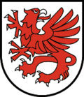
The municipal coat of arms of Gerlos was created in 1985. It primarily depicts a griffin, which is the result of the merging of the heraldic animals of Salzburg and Tyrol, the eagle and the lion. This represents the location of the community, being on the border of the states, and also represents the ties to the local archbishopship of Salzburg,

Notable people

Honorary citizens

Gerlos born

Associated

Statistics Austria - local statistics for Gerlos here.

Related Research Articles

<span class="mw-page-title-main">Innsbruck</span> Capital city of Tyrol, Austria

Innsbruck is the capital of Tyrol and the fifth-largest city in Austria. On the River Inn, at its junction with the Wipp Valley, which provides access to the Brenner Pass 30 km (19 mi) to the south, it had a population of 132,493 in 2018.

<span class="mw-page-title-main">Kitzbühel</span> Town in Tyrol, Austria

Kitzbühel is a medieval town situated in the Kitzbühel Alps along the river Kitzbüheler Ache in Tyrol, Austria, about 100 km (62 mi) east of the state capital Innsbruck and is the administrative centre of the Kitzbühel district. Kitzbühel is one of the most famous and exclusive ski resorts in the world. It is frequented primarily by the international high society and has the most expensive real estate in Austria. The proximity to Munich has made it a preferred location for vacation homes among the German elite.

<span class="mw-page-title-main">Kitzbühel Alps</span> Mountain range in Austria

The Kitzbühel Alps are a mountain range of the Central Eastern Alps surrounding the town of Kitzbühel in Tyrol, Austria. Geologically they are part of the western slate zone.

<span class="mw-page-title-main">Mayrhofen</span> Place in Tyrol, Austria

Mayrhofen is a town in the Zillertal in the Austrian state of Tyrol. It is located approximately an hour from the Tyrolean capital city of Innsbruck.

<span class="mw-page-title-main">St. Johann in Tirol</span> Market town and municipality in Tyrol, Austria

Sankt Johann in Tirol, called Sainihåns in the local dialect, is a market municipality in the Kitzbühel district of Tyrol, Austria. In the regional ductus, the last syllable of the name is stressed as "Sankt yo-Hahn'".

<span class="mw-page-title-main">Tux Alps</span> Subgroup of Austrian Central subgroup of Eastern Alps, Central Europe

The Tux Alps or Tux Prealps are a sub-group of the Austrian Central Alps, which in turn form part of the Eastern Alps within Central Europe. They are located entirely within the Austrian federal state of Tyrol. The Tux Alps are one of three mountain ranges that form an Alpine backdrop to the city of Innsbruck. Their highest peak is the Lizumer Reckner, 2,886 m (AA), which rises between the glen of Wattentaler Lizum and the valley of the Navisbach. Their name is derived from the village of Tux which is tucked away in a side valley of the Zillertal.

The Bezirk Schwaz is an administrative district (Bezirk) in Tyrol, Austria. It borders Bavaria (Germany) in the north, the districts of Kufstein, Kitzbühel and Pinzgau (Salzburg) in the east, South Tyrol (Italy) in the south, and the Innsbruck-Land district in the west.

<span class="mw-page-title-main">Mittersill</span> Place in Salzburg, Austria

Mittersill is a city in the federal state of Salzburg, Austria, in the Pinzgau region of the Alps. It is located on the Salzach River. It has a population of 5,408 as of 2011.

<span class="mw-page-title-main">Krimml</span> Place in Salzburg, Austria

Krimml is a municipality in Zell am See District, in the federal state of Salzburg, Austria, in the Pinzgau region.

<span class="mw-page-title-main">Zillertal</span> Valley in Tyrol, Austria

The Ziller Valley is a valley in Tyrol, Austria that is drained by the Ziller River. It is the widest valley south of the Inn Valley and lends its name to the Zillertal Alps, the strongly glaciated section of the Alps in which it lies. The Tux Alps lie to its west, while the lower grass peaks of the Kitzbühel Alps are found to the east.

<span class="mw-page-title-main">Zell am Ziller</span> Place in Tyrol, Austria

Zell am Ziller is a municipality in the Schwaz district in the Austrian state of Tyrol. The name derives from the river Ziller.

<span class="mw-page-title-main">Tux, Tyrol</span> Place in Tyrol, Austria

Tux is a municipality in the Schwaz district in the Austrian state of Tyrol.

<span class="mw-page-title-main">Zillertal Railway</span> Narrow gauge railway line in Austria

The Zillertal Railway or Zillertalbahn is a 760 mm gauge independent railway running along the valley of the river Ziller (Zillertal) in Tyrol, Austria. The 32 kilometres (20 mi) line starts in Jenbach and terminates in Mayrhofen.

<span class="mw-page-title-main">Ziller</span> River in Tyrol, Austria

The Ziller is a right tributary to the Inn, in the Zillertal in Tyrol, Austria. It is 55.7 km (34.6 mi) long, and its basin area is 1,135 km2 (438 sq mi). It springs from the ridge of the Zillertal Alps, and feeds the Zillergründl Dam. In Mayrhofen it receives the Zemmbach (that in turn receives the Tuxbach. By Zell am Ziller it receives the Gerlosbach, before it flows into the Inn by Strass im Zillertal.

<span class="mw-page-title-main">Venediger Group</span>

The Venediger Group is a mountain range of the Central Eastern Alps. Together with the Granatspitze Group, the Glockner Group, the Goldberg Group, and the Ankogel Group, it forms the main ridge of the High Tauern. The highest peak is the Großvenediger at 3,657 m (AA), which gives its name to the group. Considerable parts of the Venediger Group belong to the core zone of the High Tauern National Park.

Hinterwaldberg is a dispersed settlement in the Oberpinzgau, the upper Salzach valley and the district of Zell am See/Pinzgau, and is a village and Katastralgemeinde in the municipality of Wald im Pinzgau, on the southern edge of the Kitzbühel Alps in Austria.

Vorderwaldberg is a dispersed settlement in the Oberpinzgau, the upper Salzach valley and the district of Zell am See/Pinzgau, and also a village in the municipality of Wald im Pinzgau, on the southern edge of the Kitzbühel Alps in Austria.

<span class="mw-page-title-main">Tyrol</span> Region across the Alps

Tyrol is a historical region in the Alps of Northern Italy and western Austria. The area was historically the core of the County of Tyrol, part of the Holy Roman Empire, Austrian Empire and Austria-Hungary, from its formation in the 12th century until 1919. In 1919, following World War I and the dissolution of Austria-Hungary, it was divided into two modern administrative parts through the Treaty of Saint-Germain-en-Laye:

The Pinzgau Ridgeway is a roughly 25 kilometre long ridgeway in the Kitzbühel Alps in the Austrian federal state of Salzburg.

Lahn is a dispersed settlement in the Oberpinzgau, the upper Salzach valley and the district of Zell am See/Pinzgau, and a village in the municipality of Wald im Pinzgau, on the southern rim of the Kitzbühel Alps.

References

  1. "Dauersiedlungsraum der Gemeinden Politischen Bezirke und Bundesländer - Gebietsstand 1.1.2018". Statistics Austria. Retrieved 10 March 2019.
  2. "Einwohnerzahl 1.1.2018 nach Gemeinden mit Status, Gebietsstand 1.1.2018". Statistics Austria. Retrieved 9 March 2019.
  3. "Bevölkerungsstand und -struktur 01.01.2019" (PDF). statistik.at (in German). Statistik Austria. 2019-05-02. Archived (PDF) from the original on 2020-02-10. Retrieved 2020-02-10.
  4. 1 2 Michael Fritz. "Gerlos / Gerlosberg". Verein "fontes historiae - Quellen der Geschichte". Retrieved 2021-02-18.
  5. 1 2 "Gemeindechronik" (PDF). Gemeinde Gerlos. Retrieved 2021-02-18.
  6. "Ein Blick auf die Gemeinde Gerlos, Fläche und Flächennutzung" (PDF). Statistik Austria. Retrieved 2021-02-18.
  7. Willibald Hauthaler, Franz Martin: Salzburger Urkundenbuch, Band II. Salzburg 1910, Nr. 308; Martin Bitschnau; Hannes Obermair (2012). Tiroler Urkundenbuch, II. Abteilung: Die Urkunden zur Geschichte des Inn-, Eisack- und Pustertals. Band 2: 1140–1200. Innsbruck: Universitätsverlag Wagner. pp. 102–103, Nr. 507. ISBN   978-3-7030-0485-8.
  8. "Kirchengeschichte" (in Austrian German). Gemeinde Gerlos. Retrieved 2021-02-18.
  9. "VERBUND-Storage Power Plant Funsingau in Gerlostal in Tyrol". www.verbund.com. Retrieved 2022-10-21.
  10. "Ein Blick auf die Gemeinde Gerlos, Übernachtungen" (PDF). Statistik Austria. Retrieved 2021-02-18.
  11. "Klettersteig Riederklamm". Klettersteig.de. 2014-10-15. Retrieved 2019-09-28.
  12. "Land Tirol - Wahlen 2016" . Retrieved 2021-02-18.
  13. "Land Tirol - Wahlen 2016" . Retrieved 2021-02-18.
  14. "Land Tirol - Wahlen 2010" . Retrieved 2021-02-18.
  15. "Gemeinderatswahl 2010" (in Austrian German). Gemeinde Gerlos. Retrieved 2021-02-18.
  16. 80igster Geburtstag Altbürgermeister Hans Kammerlander. Gerloser Gemeindeblatt März 2007