Tux, Tyrol

Last updated
Tux
Hintertux 2006.jpg
Wappen at tux.png
Map at-7 tux.png
Location within Tyrol
Austria adm location map.svg
Red pog.svg
Tux
Location within Austria
Coordinates: 47°07′00″N11°40′00″E / 47.11667°N 11.66667°E / 47.11667; 11.66667
Country Austria
State Tyrol
District Schwaz
Government
   Mayor Simon Grubauer
Area
[1]
  Total111.13 km2 (42.91 sq mi)
Elevation
1,281 m (4,203 ft)
Population
 (2018-01-01) [2]
  Total1,941
  Density17/km2 (45/sq mi)
Time zone UTC+1 (CET)
  Summer (DST) UTC+2 (CEST)
Postal code
6293
Area code 05287
Vehicle registration SZ
Website gemeinde-tux.at OOjs UI icon edit-ltr-progressive.svg

Tux is a municipality in the Schwaz district in the Austrian state of Tyrol.

Contents

Geography

The parish of Tux covers the higher and largest part of the Tuxertal, a side valley of the Zillertal that branches off at Mayrhofen. The territory of the parish extends to the glaciated peak of Olperer (3,476 m) and the 2,338 m high saddle of the Tuxer Joch, a crossing between the Zillertal and Wipptal valleys that was heavily used even in the protohistoric period. Other prominent peaks within the municipality are the 3,288 m high Gefrorene Wand Spitze and the 3,231 m high Hoher Riffler. The highest farmsteads lie at a height of 1,630 m.

Tux consists of the five villages of Tux-Vorderlanersbach (former Vorderlanersbach), Tux-Lanersbach (former Lanersbach), Juns, Madseit, and Hintertux.

On 25 January 2005 the state government renamed Lanersbach to Tux-Lanersbach and Vorderlanersbach to Tux-Vorderlanersbach because, although the municipality as a whole was called Tux, there was no actual village with the name.

Tux-Vorderlanersbach (1,300 m above sea level (AA)) is the first village along the road from Finkenberg. On the mountainside above lie the hamlets of Schöneben and Gemais. The farming settlement of Gemais at 1,450 m was placed under conservation protection as it has a historical coherence and unity of architectural style that date back to the 17th century. It developed from a former Schwaighof - a type of livestock farm typical of the Alpine region. The 2,292 m high hamlet of Geiseljoch lies on the way into the Inn valley that was once a busy trading route to the markets in Hall in Tirol and Innsbruck. From Vorderlanersbach there is a single-cable gondola lift to the Rastkogel skiing area, which in turn is linked to the nearby skiing areas of Penken and Eggalm.

Tux-Lanersbach (1,300 m above sea level (AA)) lies about two kilometres beyond Vorderlanersbach and forms the cultural and business heart of the Tuxertal. Tux-Lanersbach is both the seat of the municipality of Tux as well as a church parish that has existed since 1891. The parish church in Tux-Lanersbach was built in 1686 in place of an older Gothic church and was converted to the baroque style in 1750. In the south of the village at the Höllenstein Hut (about 1,800 m), a small farm museum has been established. A cable lift leads to the Eggalm ski and hiking area.

Juns (1,400 m above sea level (AA)) is a long drawn out village about 2 km up the valley from Tux-Lanersbach. It comprises several small hotels and private homes. There is a show mill worth seeing here that used to grind the barley corn grown here right up until just a few decades ago. Two toboggan runs descend from the Höhlenstein Hut and the alpine pasture of Grieralm, both roughly 5 km long, ending in Juns. The runs are lit and can be used in the evening.

Madseit (1,450 m above sea level (AA)) lies beyond the village of Juns and is a small settlement with several hotels, boarding houses and private homes. The valley narrows then behind the little hamlet, at the confluence of the Madseitbach and the Tuxerbach.

Hintertux (1,500 m above sea level (AA)) lies furthest up the valley at the foot of the Hintertux Glacier (one of the most popular summer skiing regions in Austria), and is surrounded by mountains and glaciers. It consists of hotels, guest houses and scattered farmhouses. The Church of the Assumption (Kirche Maria Himmelfahrt) was completed in 1952 on the site of a previous one that had been blown up in 1941.

In Hintertux are the highest thermal baths in Europe, with their various mineral springs. In the immediate vicinity of the Spannagelhaus lies the Spannagel Cave, that is over 10 km long and the largest natural cave in the Austrian Central Alps. The cave is under a preservation order and may only be visited as part of a guided tour.

At the Tuxer Ferner glacier is an all-season skiing area with a large number of lifts. The place is the base for many walks and high Alpine tours. The Hintertux Glacier Ski Region (Skigebiet Hintertuxer Gletscher) belongs to the Zillertal 3000 ski region and is a popular with skiers in summer as well as winter.

Hintertux has a population of 178 (as at: 2006). Until 1926 it belonged to the parish of Schmirn am Brenner.

Neighbouring parishes

Finkenberg, Hippach, Kolsassberg, Navis, Schmirn, Schwendau, Wattenberg, Weerberg

History

The Tuxer valley was first mentioned in the records in 1280.

The Tuxer valley was discovered in prehistoric times as evinced by various finds from the middle Stone Age. The first settlers in the valley were probably Breuni, who came from the Raeti tribe and settled in the Wipptal.

Shepherds and miners also settled the valley, migrating over the Tuxer Joch from the Schmirn valley and cultivating it by clearing forests. In 889 the Tux valley, along with other parts of the Zillertal, went to the Archdiocese of Salzburg. In 1280 the name Tux (Tukkes) was first mentioned in the records. Originally referring to pure water, the term was adopted as the name of the valley. It is probably derived from the Indo-Germanic root, teg, which means "running, "flowing" or "melting away". The first farms were of the Schwaighof type and had to pay their taxes in kind e.g. in livestock.

The remotest valley between Lanersbach and Hintertux was, until 1438, a fief of the court of Matrei am Brenner and later Steinach am Brenner. Until 1926 Hintertux belonged to the parish of Schmirn. In 1926 Hintertux merged with Lanersbach and the mining office of Lämperbichl (Hauptmannschaft Lämperbichl) to form the parish of Tux.

Economy

Agriculture

The meadows and alpine pastures in the Tux valley continue to be cultivated even today, albeit most farms only provide a secondary source of income.

Tourism

Tourism is the most important branch of the economy in the valley today with numerous hotels, restaurants and accommodation providers being established here. Three ski regions have been opened up for the ski tourism industry: the first was the Eggalm region in 1961; it was joined in 1968 by the Hintertux Glacier and from 1984 by the Rastkogel, which has been linked to the Penken Ski Region since 2001 by a shuttle lift. During the 2000s the capacity of the lift infrastructure was massively increased. The Hintertux Glacier was operated as an all-year skiing area from the outset. Just as important for the region is the merger of the Tux ski regions with those in the direction of Finkenberg and Mayrhofen (Penken). After Mayrhofen, Tux has the second-highest number of overnight guests in the Zillertal.

Magnesite factory

From 1927 to 1976 the Tux Magnesite Mine, about 500 m above Vorderlanersbach, was the highest of its kind in Europe. Using open-cast and underground mining up to 400 workers mined magnesite. Special cableways for workers and materiel linked the factory with Lanersbach and the loading station in the Zillertal near Mayrhofen. On the Schrofenalm, about 500 m away from the factory, was a small settlement with accommodation, a school, a grocer's shop, a cinema and other facilities for factory employees and their families. When the factory closed in 1976 it was completely demolished and the area renaturalised. All that remains are St. Barbara's Chapel, built in 1947 based on plans by Hubert Prachensky with frescoes by Max Weiler, and two former worker's houses, the Schrofenhäuser.

Transport

Tux is accessible from Mayrhofen by road. From Mayrhofen station on the Ziller Valley Railway there is a bus service. The nearest Austrian Federal Railway station is at Jenbach, which is also the departure station for the Ziller Valley Railway. Within the Tux valley there is a free bus service - the Tuxer Sportbus - that runs during the day between Vorderlanersbach and Hintertux. In the winter months there is also a fare-charging Nightliner bus until 2 a.m.

Related Research Articles

<span class="mw-page-title-main">Stubai Alps</span> Mountain range in Central Europe

The Stubai Alps is a mountain range in the Central Eastern Alps of Europe. It derives its name from the Stubaital valley to its east and is located southwest of Innsbruck, Austria. Several peaks form the border between Austria and Italy. The range is bounded by the Inn River valley to the north; the Sill River valley (Wipptal) and the Brenner Pass to the east ; the Ötztal and Timmelsjoch to the west, and to the south by tributaries of the Passer River and Eisack.

<span class="mw-page-title-main">Mayrhofen</span> Place in Tyrol, Austria

Mayrhofen is a town in the Zillertal in the Austrian state of Tyrol. It is located approximately an hour from the Tyrolean capital city of Innsbruck.

<span class="mw-page-title-main">Zillertal Alps</span> Mountain range on the border of Austria and Italy

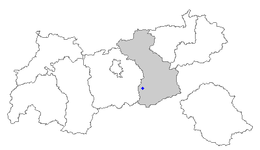
The Zillertal Alps are a mountain range of the Central Eastern Alps on the border of Austria and Italy.

<span class="mw-page-title-main">Tux Alps</span> Subgroup of Austrian Central subgroup of Eastern Alps, Central Europe

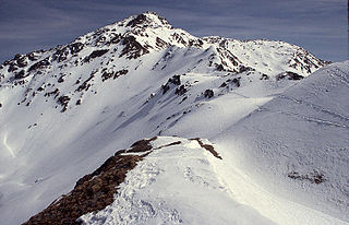
The Tux Alps or Tux Prealps are a sub-group of the Austrian Central Alps, which in turn form part of the Eastern Alps within Central Europe. They are located entirely within the Austrian federal state of Tyrol. The Tux Alps are one of three mountain ranges that form an Alpine backdrop to the city of Innsbruck. Their highest peak is the Lizumer Reckner, 2,886 m (AA), which rises between the glen of Wattentaler Lizum and the valley of the Navisbach. Their name is derived from the village of Tux which is tucked away in a side valley of the Zillertal.

The Bezirk Schwaz is an administrative district (Bezirk) in Tyrol, Austria. It borders Bavaria (Germany) in the north, the districts of Kufstein, Kitzbühel and Pinzgau (Salzburg) in the east, South Tyrol (Italy) in the south, and the Innsbruck-Land district in the west.

<span class="mw-page-title-main">Zillertal</span> Valley in Tyrol, Austria

The Ziller Valley is a valley in Tyrol, Austria that is drained by the Ziller River. It is the widest valley south of the Inn Valley and lends its name to the Zillertal Alps, the strongly glaciated section of the Alps in which it lies. The Tux Alps lie to its west, while the lower grass peaks of the Kitzbühel Alps are found to the east.

<span class="mw-page-title-main">Noric Alps</span>

The Noric Alps is a collective term denoting various mountain ranges of the Eastern Alps. The name derives from the ancient Noricum province of the Roman Empire on the territory of present-day Austria and the adjacent Bavarian and Slovenian area.

<span class="mw-page-title-main">Gerlos</span> Place in Tyrol, Austria

Gerlos is a municipality with 793 inhabitants in Schwaz district of the Austrian state of Tyrol. The village is popular with skiing tourists, mainly families, as there is easy access to Zillertal Arena Centre on Isskogel. The village lies in the Zell am Ziller judicial district.

<span class="mw-page-title-main">Gschnitz</span> Place in Tyrol, Austria

Gschnitz is a municipality with 415 inhabitants in the south of North Tyrol.

<span class="mw-page-title-main">Schmirn</span> Place in Tyrol, Austria

Schmirn is a municipality in the District Innsbruck-Land in the Austrian state of Tyrol.

<span class="mw-page-title-main">Zillertal Arena</span> Ski resort in Tyrol, Austria

The Zillertal Arena is a winter sports area and the largest ski area in the Zillertal valley in Austria. It has 163 kilometres of piste and 50 lifts that can transport 76,000 people every hour. It consists of two parts: one with valley lifts from Zell, Gerlos and Königsleiten and anothern with valley lifts from Ramsau and Hainzenberg.

<span class="mw-page-title-main">Tuxertal</span> Valley in Tyrol, Austria

The Tuxertal is a valley located in Tyrol, Austria. A side valley of the Zillertal, from which it branches at Mayrhofen, the Tuxertal is about 13 km long and accessible on the Tuxer Straße. From Mayrhofen to Hintertux (1500 m) in the municipality of Tux, the village that gives the valley its name, there is a height difference of about 850 m. The valley ends at Hintertux and the Hintertux Glacier. The Tuxbach, which rises near Hintertux, flows as far as Mayrhofen where it empties into the River Ziller.
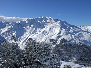
<span class="mw-page-title-main">Olperer</span>

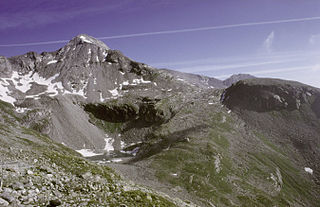
The Olperer is a 3,476-metre-high (11,404 ft) mountain in the Zillertal Alps in the Austrian federal state of Tyrol. It is the main summit on the Tux Crest and is often crossed in the summer as climbers transit from the Olperer Hut to the Geraer Hut. It was first climbed on 10 September 1867 along the southeast ridge (Südostgrat) by Paul Grohmann, Georg Samer and Gainer Jackl. On its north flank is the ski region known as Hintertux Glacier on the Gefrorene-Wand-Kees glacier.

<span class="mw-page-title-main">Gefrorene-Wand-Spitzen</span> Two summitsin the Zillertal Alps, Austria

The Gefrorene-Wand-Spitzen are two summits on the Tux Crest, a mountain chain in the Zillertal Alps, one of the ranges of the central Eastern Alps in the Austrian state of Tyrol. The north summit (Nordgipfel) is recorded as 3,286 metres high in the literature, but is 3,288 metres high according to the Federal Office for Metrology and Survey. The south summit (Südgipfel), by contrast, is only 3,270 metres high. The two peaks are about 300 metres apart. They appear from the north as a stubby, cone-shaped, firn-covered dome, but from the east as a forbidding, dark rock face. Sharp, prominent ridges radiate from the peaks to the northeast and southwest, along the main crest of the mountain range. The twin peaks are the highest points in the summer skiing area of the Hintertux Glacier and, since the end of the 1990s, have been accessible from Hintertux on cable cars and ski lifts; which makes them a popular destination for day trippers. The north summit was first conquered in 1867 by Dr. Berreitter, the south summit on 7 September 1872 by brothers Max and Richard von Frey from Salzburg.

<span class="mw-page-title-main">Hoher Riffler (Zillertal Alps)</span>

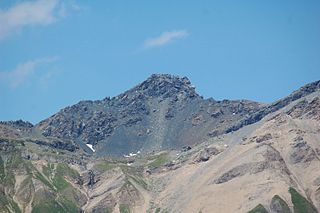
The Hoher Riffler is a 3,231 metre high mountain in the Zillertal Alps, on the eastern part of the main chain of the Tux, in the Austrian state of Tyrol. The peak is firn-covered on its northern side, but from the south it looks like a rocky summit. Ridges run from the top towards the southwest, north, northeast and southeast, some of them carrying approach paths. The summit is easily attained from the mountain hut of Spannagelhaus to the west or the Friesenberghaus to the south and, as a result, is often visited. In winter it is an easy destination for ski mountaineers. The peak was first ascended during the Austrian national survey. The first tourist climber, according to the literature, was one H. Weber, guided by Georg Samer in 1875.

<span class="mw-page-title-main">Tuxer Joch</span>

The Tuxer Joch is a mountain pass in the Zillertal Alps at a height of 2,338 m (AA) that links the lower Zillertal valley with the Brenner route just north of the Brenner Pass. To the northeast just below the summit lies the Tuxer Joch-Haus.

<span class="mw-page-title-main">Lizumer Reckner</span>

The Lizumer Reckner is, at 2,886 m above sea level (AA), the highest mountain in the Tux Alps in the Austrian state of Tyrol.

<span class="mw-page-title-main">Rastkogel</span> Tux Alps main crest mountain, Tyrol, Austria

The Rastkogel is a 2,762 metre high, pyramidal, mountain on the main crest of the Tux Alps in the Austrian federal state of Tyrol.

<span class="mw-page-title-main">Garnet Chapel</span>

The Roman Catholic Garnet Chapel, known in German as 'Granatkapelle', is situated at the Penken saddle near the Penken. This religious building can be found northeast of an artificial lake and forms part of the community of Finkenberg in the Zillertal (valley). This valley in the district of Schwaz is in the state of Tyrol. The chapel belongs to the parish of Finkenberg, therefore to the Deanery of Fuegen-Jenbach and thus to the Roman Catholic Diocese of Innsbruck.

<span class="mw-page-title-main">Geier (Tux Alps)</span>

The Geier is, at 2,857 m above sea level (AA), the second highest mountain in the Tux Alps in the Austrian state of Tyrol.

References

  1. "Dauersiedlungsraum der Gemeinden Politischen Bezirke und Bundesländer - Gebietsstand 1.1.2018". Statistics Austria. Retrieved 10 March 2019.
  2. "Einwohnerzahl 1.1.2018 nach Gemeinden mit Status, Gebietsstand 1.1.2018". Statistics Austria. Retrieved 9 March 2019.