Vernon Parish is a parish located in the U.S. state of Louisiana. As of the 2010 census, the population was 52,334. The parish seat is Leesville. Bordered on the west by the Sabine River, the parish was founded in 1871 during the Reconstruction era.

Tensas Parish is a parish located in the northeastern section of the State of Louisiana; its eastern border is the Mississippi River. As of the 2010 census, the population was 5,252. It is the least populated parish in Louisiana. The parish seat is St. Joseph. The name Tensas is derived from the historic indigenous Taensa people. The parish was founded in 1843 following Indian Removal.

St. Tammany Parish is a parish located in the U.S. state of Louisiana. As of the 2010 census, the population was 233,740, making it the fifth-most populous parish in Louisiana. The parish seat is Covington. The parish was founded in 1810.

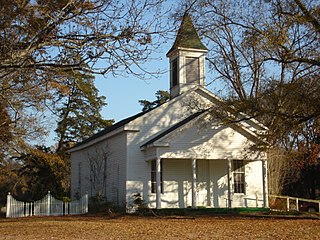
Pointe Coupee Parish,, is a parish located in the U.S. state of Louisiana. As of the 2010 census, the population was 22,802. The parish seat is New Roads.

Jefferson Davis Parish is a parish located in the U.S. state of Louisiana. As of the 2010 census, the population was 31,594. The parish seat is Jennings. Jefferson Davis Parish is named after the president of the Confederacy during the American Civil War, Jefferson Davis. It is located in southwestern Louisiana and forms a part of the Acadiana region.

East Carroll Parish is a parish located in the Mississippi Delta in northeastern Louisiana, part of what was called the Natchez District of cotton parishes. As of the 2010 census, the population was 7,759. The parish seat is Lake Providence. An area of cotton plantations in the antebellum era, the parish in the early 21st century has about 74% of its land devoted to agriculture.

Marrero is a census-designated place (CDP) in Jefferson Parish, Louisiana, United States. Marrero is on the south side of the Mississippi River, within the New Orleans–Metairie–Kenner Metropolitan Statistical Area. The population was 33,141 at the 2010 census.

Bastrop is the largest city and the parish seat of Morehouse Parish, Louisiana, United States. The population was 11,365 at the 2010 census, a decrease of 1,623 from the 12,988 tabulation of 2000. The population of Bastrop is 73 percent African American. It is the principal city of and is included in the Bastrop, Louisiana Micropolitan Statistical Area, which is included in the Monroe-Bastrop, Louisiana Combined Statistical Area.
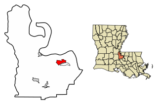
New Roads is a city in and the parish seat of Pointe Coupee Parish, Louisiana, United States. The center of population of Louisiana is located in New Roads. The population was 4,831 at the 2010 census, down from 4,966 in 2000. The city's ZIP code is 70760. It is part of the Baton Rouge Metropolitan Statistical Area.
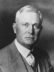
Oscar Kelly Allen Sr., also known as O. K. Allen, was the 42nd Governor of Louisiana from 1932 to 1936.

Delgado Community College(DCC) is a community college in Louisiana with campuses throughout the New Orleans metropolitan area, the East and West Banks of New Orleans, the East Bank of Jefferson Parish and on the North Shore of Lake Pontchartrain in Covington and Slidell in St. Tammany Parish. The original main campus—City Park Campus—is located in the Navarre neighborhood adjacent to New Orleans City Park.

Belle River is a small unincorporated community in the U.S. state of Louisiana. It is situated on the eastern side of the Avoca Island Cutoff and the far west side of Shell Beach Road

U.S. Highway 90 (US 90), one of the major east–west U.S. Highways in the Southern United States, runs through southern Louisiana for 297.6 miles (478.9 km), serving Lake Charles, Lafayette, New Iberia, Morgan City, and New Orleans. Much of it west of Lafayette and east of New Orleans has been supplanted by Interstate 10 (I-10) for all but local traffic, but the section between Lafayette and New Orleans runs a good deal south of I-10.
Oscar is an unincorporated community located in the southeastern portion of Pointe Coupee Parish, Louisiana, United States. It is located primarily along Louisiana Highway 1 on the southern end of False River. Famous residents include renowned author Ernest Gaines. This community was formerly home to the Oxbow restaurant and Bonaventure's Landing.
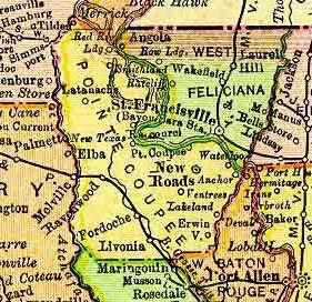
Red River Landing was the name of a community located in northern Pointe Coupee Parish, Louisiana, United States. The community was located near the Red River and the Mississippi River.
Yucatan Landing is an unincorporated community in Tensas Parish in northeastern Louisiana, United States.
Alabama Landing is an unincorporated community in Union Parish, Louisiana, United States.
Good Hope is an unincorporated community in St. Charles Parish, Louisiana, United States.
New Era is an unincorporated community in Concordia Parish, Louisiana, United States. The community is located at the western edge of Concordia Parish on LA 129.
Charlieville is an unincorporated community in Richland Parish, Louisiana, United States. The community is located 17 miles SE of Monroe, Louisiana.