North Tyneside is a metropolitan borough in the metropolitan county of Tyne and Wear, England. It forms part of the greater Tyneside conurbation. North Tyneside Council is headquartered at Cobalt Park, Wallsend.
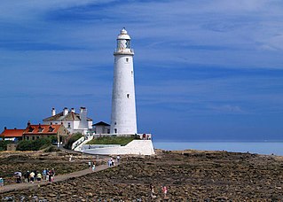
Whitley Bay is a seaside town in the North Tyneside borough in Tyne and Wear, England. It was formerly governed as part of Northumberland and has been part of Tyne and Wear since 1974. It is part of the wider Tyneside built-up area, being around 10 miles (16 km) east of Newcastle upon Tyne. Two notable landmarks are the Spanish City and St. Mary's Lighthouse, the latter on a small island near the town.

Blyth Valley was a local government district with borough status in south-east Northumberland, England, bordering the North Sea and Tyne and Wear. The two principal towns were Blyth and Cramlington. Other population centres include Seaton Delaval, and Seaton Sluice.

Cramlington is a town and civil parish in Northumberland. It is 6 miles north of Newcastle upon Tyne. The name suggests a probable founding by the Danes or Anglo-Saxons.

Monkseaton is an area of Whitley Bay, North Tyneside, in the county of Tyne and Wear, England. Historically in Northumberland, it is in the north-east of the borough, 3⁄4 mile from the North Sea coast and 1+1⁄2 mi (2.5 km) north of the River Tyne at North Shields. One mile to the north of Monkseaton, the extensive built-up areas of North Tyneside change abruptly into green belt stretching north into south-east Northumberland. It is at an elevation of 130 feet (40 m) above sea-level.

Earsdon is a village in the borough of North Tyneside in the county of Tyne and Wear, England. It sits on the border of Northumberland, which it is historically part of, and is approximately two miles from Whitley Bay. The village had a population of 613 in 2011.

Tynemouth is a constituency in Tyne and Wear represented in the House of Commons of the UK Parliament since 1997 by Sir Alan Campbell, a member of the Labour Party.

Blyth Valley, formerly known as Blyth, was a constituency most recently represented in the House of Commons of the UK Parliament from 2019 by Ian Levy, a Conservative until its abolition in 2024.

Seaton Delaval is a village and former civil parish, now in the parish of Seaton Valley, in Northumberland, England, with a population of 4,371. The largest of the five villages in Seaton Valley, it is the site of Seaton Delaval Hall, completed by Sir John Vanbrugh in 1727.

Seaton Valley was an urban district in Northumberland, England, from 1935 to 1974, at which point it was split between the districts of North Tyneside and Blyth Valley.
The Northern Football Alliance is a football league based in the North East, England. It has four divisions headed by the Premier Division, which sits at step 7 of the National League System.

Seaton Sluice is a village in Northumberland. It lies on the coast at the mouth of the Seaton Burn, midway between Whitley Bay and Blyth. In the 2021 census the village had a population of 2,956.
Seaton Burn is a village in North Tyneside, Tyne and Wear, to the north of Newcastle upon Tyne, and adjacent to Wideopen which is just south of it. It is part of the wider Seaton valley in which some Seaton villages are in Northumberland, and others in North Tyneside, Tyne and Wear. This is because the area lies on the border between the two counties.

The Tyneside Passenger Transport Executive was the operations arm of the Tyneside Passenger Transport Authority, created by the Transport Act 1968. and came into operation on 1 January 1970.

North Tyneside Council, or North Tyneside Metropolitan Borough Council, is the local authority for the metropolitan borough of North Tyneside in Tyne and Wear, England. It is a metropolitan borough council and provides the majority of local government services in the borough. The council has been a member of the North East Combined Authority since 2024.
The county of Northumberland has returned four MPs to the UK Parliament since 1983. Under the 2023 review of Westminster constituencies, coming into effect for the 2024 general election, the boundary commission proposed that two of the four constituencies be shared with the county of Tyne and Wear.

Cramlington and Killingworth is a constituency of the House of Commons in the UK Parliament. Further to the completion of the 2023 Periodic Review of Westminster constituencies, it was first contested at the 2024 general election and is currently held by Emma Foody, a Labour and Co-operative MP.

