Sede, district of Santa Maria

Last updated
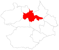
District of Sede
Sede, the 1st district of Santa Maria
Distrito.Sede.Santa Maria.RS.v2006.png
District of Sede, in Santa Maria City, Rio Grande do Sul, Brazil
Coordinates: 29°41′51.93″S53°47′15.61″W / 29.6977583°S 53.7876694°W / -29.6977583; -53.7876694
Country Brazil
State Rio Grande do Sul
Municipality/City Santa Maria
Government
  Type Subprefecture
  Body Subprefect
Area
   District
133.71 km2 (51.63 sq mi)
Highest elevation
300 m (980 ft)
Lowest elevation
60 m (200 ft)
Population
[1]
   District
246,465
  Rank1st of 10
  Density1,843.3/km2 (4,774.1/sq mi)
   Urban
246,465
   Rural
0
Neighbourhoods 41
Adjacent districts Arroio Grande, Boca do Monte, Pains, Palma, Santo Antão, São Valentim
Website Official site of Santa Maria

Sede [2] ("Seat") is a district of the municipality of Santa Maria, in the Brazilian state of Rio Grande do Sul. It is situated in the north portion of Santa Maria. Downtown Santa Maria is one of its bairros (neighbourhoods).

Contents

The district of Sede owns an area of 133.71 km² that is equivalent to 7.46% of the municipality of Santa Maria that is 1791,65 km².

History

The district was created with the denomination of Santa Maria da Boca do Monte, by provincial law number 6 of 1837, November 17, [3] thus, the district still belonged to the municipality of Cachoeira do Sul. After, as Seat of the municipality of Santa Maria, the district gave origin, for separation, to many another districts, and, some of them became municipalities like Itaara.

The district of Sede contains the Downtown Santa Maria.

In 1982, the district had its first official division in bairros, [4] in 1986 are made small changes. [5] However, it was created detached bairros before 1982, like is the case of Bairro Roberto Holtermann that was created in 1961, [6] and nowadays is part of the Nossa Senhora de Fátima neighbourhood with the name of Vila Holtermann.

The bairros - neighbourhoods - of Sede created in 1986 endured up to 2006, when the city hall and the city council created the actual bairros of the district, and:

Difference between the division of 1986 (black lines) and of 2006 (bairros in colours).


Bairros from 1986 to 2006

A - Centro  B - Nossa Senhora das Dores  C - Nossa Senhora de Lourdes  D - Medianeira  E - Nossa Senhora do Rosário  F - Salgado Filho  G - Chácara das Flores  H - Nossa Senhora do Perpétuo Socorro  I - Itararé  J - Presidente João Goulart  K - Km Três  L - São José  M - Cerrito  N - Urlândia  O - Tomazzetti  P - Patronato  Q - Passo d'Areia  R - Juscelino Kubitschek  S - Caturrita  T - Pé de Plátano  U - Camobi  V - Cohab Camobi  W - Cohab Passo da Ferreira  X - Parque Pinheiro Machado


Bairros from 2006 on

1 - Centro  2 - Bonfim  3 - Nonoai  4 - Nossa Senhora de Fátima  5 - Nossa Senhora de Lourdes  6 - Nossa Senhora do Rosário  7 - Nossa Senhora Medianeira  8 - Camobi  9 - Carolina  10 - Caturrita  11 - Chácara das Flores  12 - Divina Providência  13 - Nossa Senhora do Perpétuo Socorro  14 - Salgado Filho  15 - Diácono João Luiz Pozzobon  16 - Cerrito  17 - Pé de Plátano  18 - São José  19 - Campestre do Menino Deus  20 - Itararé  21 - Km 3  22 - Menino Jesus  23 - Nossa Senhora das Dores  24 - Presidente João Goulart  25 - Lorenzi  26 - Tomazetti  27 - Urlândia  28 - Dom Antônio Reis  29 - Duque de Caxias  30 - Noal  31 - Passo d'Areia  32 - Patronato  33 - Uglione  34 - Agroindustrial  35 - Boi Morto  36 - Juscelino Kubitschek  37 - Pinheiro Machado  38 - Renascença  39 - Nova Santa Marta  40 - São João  41 - Tancredo Neves

Limits

The district limits with the districts of Arroio Grande, Boca do Monte, Pains, Palma, Santo Antão and São Valentim, and with the municipality of Itaara.

Neighbourhoods

The district of Sede is divided in the following bairros, that in English is equivalent to neighbourhoods:

  1. Agroindustrial
  2. Boi Morto
  3. Bonfim
  4. Camobi
  5. Campestre do Menino Deus
  6. Carolina
  7. Caturrita
  8. Centro
  9. Cerrito
  10. Chácara das Flores
  11. Divina Providência
  12. Dom Antônio Reis
  13. Duque de Caxias
  14. Itararé
  15. Diácono João Luiz Pozzobon
  16. Juscelino Kubitschek
  17. Km 3
  18. Lorenzi
  19. Menino Jesus
  20. Noal
  21. Nonoai
  22. Nossa Senhora das Dores
  23. Nossa Senhora de Fátima
  24. Nossa Senhora de Lourdes
  25. Nossa Senhora do Perpétuo Socorro
  26. Nossa Senhora do Rosário
  27. Nossa Senhora Medianeira
  28. Nova Santa Marta
  29. Passo d'Areia
  30. Patronato
  31. Pé de Plátano
  32. Pinheiro Machado
  33. Presidente João Goulart
  34. Renascença
  35. Salgado Filho
  36. São João
  37. São José
  38. Tancredo Neves
  39. Tomazetti
  40. Uglione
  41. Urlândia

Roads and railway

References

  1. Population of the territories of Santa Maria. Brazilian Institute of Geography and Statistics in Portuguese.
  2. Municipal Law 0072 of 2009 that establishes the law of use and occupation of the soil, subdivision, urban perimeter and road system of the municipality of Santa Maria. Archived 2016-09-18 at the Wayback Machine - in Portuguese
  3. IBGE about Santa Maria
  4. "Municipal law 2410/82, of 10-14-1982" (PDF). Archived from the original (PDF) on 2017-12-22. Retrieved 2012-11-28.
  5. "Municipal law 2770/86, of 07.02.1986" (PDF). Archived from the original (PDF) on 2017-12-22. Retrieved 2012-11-28.
  6. "Municipal law 939, of 05.25.1961" (PDF). Archived from the original (PDF) on 2017-12-22. Retrieved 2012-11-28.