Sehome | |
---|---|
![]() View of Sehome from Sehome Hill | |
![]() | |
Coordinates: 48°44′24″N122°28′31″W / 48.74000°N 122.47528°W | |
Country | United States |
State | Washington |
County | Whatcom |
City | Bellingham |
Platted | 1854 |
Incorporated | 1888 |
Amalgamated | 1891 |
ZIP code | 98225 |
Sehome Hill Historic District | |
![]() Homes in the historic district | |
Location | Bellingham, Washington, U.S. |
Built | 1875–1949 |
Architectural style | American Craftsman, Late Victorian |
NRHP reference No. | 01000063 |
Added to NRHP | February 13, 2001 [1] |
Sehome is a neighborhood in Bellingham, Washington, United States. It was the first town on Bellingham Bay and was founded in May 1858 by coal mine manager Edmund C. Fitzhugh, who named the settlement for his father-in-law, S'Klallam chief Sehome. The townsite was originally owned by the Bellingham Bay and British Columbia Railroad, which operated the Bellingham Bay Coal Mine until it closed in 1878. The town of Sehome was amalgamated in 1891 with three other settlements into New Whatcom, which was later renamed to Bellingham.
The neighborhood now constitutes the southern part of downtown Bellingham and nearby residential areas that were developed in the early 20th century. It includes the Sehome Hill Arboretum and is adjacent to the Western Washington University campus, which lies to the southwest of the neighborhood. The Sehome Hill Historic District was added to the National Register of Historic Places in 2001.
The area around Bellingham Bay is the ancestral home of several Coast Salish peoples, including the Lummi, Nooksack, Nuwhaha, and Samish. The first non-native settlers in the area were Henry Roeder and Russell Peabody, who built a lumber mill on Whatcom Creek and staked land claims around the stream in 1852. [2] [3] Roeder's claim was south of the creek in modern-day Sehome, where two of his employees discovered coal in the roots of a fallen tree while logging. Roeder sold his land to the Bellingham Bay Coal Company, which amassed 3,000 acres (1,200 ha) for a coal mine that would fill loaded ships bound for California from a new dock on Bellingham Bay. [2] [3]
The town of Sehome was platted in May 1858 by Edmund C. Fitzhugh, the manager of the coal mine, and was the first town on Bellingham Bay. It was named for S'Klallam [4] chief Sehome (Klallam : sx̣ʷiʔám̕), Fitzhugh's father-in-law. [5] [6] The coal mine's growth was briefly stymied after new regulations from the Colony of British Columbia required coal mines to obtain permits from the colonial government in Victoria. Sehome grew from 80 residents in 1860 to 258 in 1870; three years later, the mine employed 100 white and Chinese men. [2] The Bellingham Bay Coal Mine closed in 1878 as the quality of coal declined despite the excavation of deeper tunnels to find higher-quality veins. [2]
The town relied on trade through its deep-water dock after the closure of the coal mine. Sehome was cleared of its forests and permanent buildings were constructed in the 1880s following the activation of an electrical power plant by the Bellingham Bay Improvement Company (successor to the coal mine). [2] Sehome was incorporated in 1888 and amalgamated into the town of New Whatcom in 1891 alongside neighboring Whatcom. [3] The settlement was later renamed Whatcom in 1910 and Bellingham in 1903 after it had absorbed two more towns. [2] In 1893, the Washington state government chose a site south of Sehome for the New Whatcom Normal School, a teacher's school that later expanded to become Western Washington University. [7]
The Sehome neighborhood had several streetcar lines that connected to other areas of Bellingham until the system was replaced by buses in 1938. The lines spurred the development of streetcar suburbs, including in Sehome, and created demand for residential areas throughout the former town. [2] The east side of the neighborhood was developed in the 1930s following the completion of Maple Valley Road (now Samish Way), which was later designated as part of U.S. Route 99—the main north–south highway in Western Washington. The highway was bypassed by the construction of Interstate 5, which was completed around Bellingham in 1960. [8] The city's first suburban shopping center, named Bellingham Mall, was opened in 1969 next to the freeway's interchange with Samish Way in southeastern Sehome. [9] It was later eclipsed in importance by Bellis Fair and renamed to Sehome Village after it was rebuilt in 1991. [8] [10]
The Sehome Hill Historic District was added to the National Register of Historic Places on February 13, 2001, following a three-year campaign by local residents to recognize the neighborhood's historic residential architecture. The designation includes more than 200 eligible properties, mostly built before 1930, on nine streets. [11]
The neighborhood lies between Downtown Bellingham to the north and the Western Washington University campus to the south. It includes the northern side of Sehome Hill, which rises 640 feet (200 m) above sea level and also encompasses the Sehome Hill Arboretum. [12] [13] Most of the neighborhood's streets are arranged in the same grid as Downtown Bellingham with north–south streets named in alphabetical order ascending from the waterfront. The street blocks were designed to have 16 lots and an alleyway. [12] The city government's official boundaries for Sehome are defined by N. State Street to the northwest, E. Holly Street and Ellis Street to the northeast, N. Samish Way to the east, Bill McDonald Parkway and the Western Washington University campus to the south, and Cedar and Garden streets to the southwest. [14]
Most of Sehome lies within Whatcom County Census Tract 10, which also includes the Western Washington University campus. As of the 2020 census, the tract had a total population of 8,065 people—an increase of 13 percent from the 2010 census. The racial makeup of the tract was 77.1% White, 2.3% Black, 0.6% Native American, 5.3% Asian, 0.3% Pacific Islander, and 2.9% from other races; 11.4% of people identified with two or more races. Hispanic or Latino residents of any race were 8.6% of the population. [15]
The neighborhood is split between two Bellingham City Council wards that each elect a councilmember: Ward 3, which includes Downtown Bellingham and neighborhoods to the east; and Ward 5, which includes Western Washington University. [16] Sehome is represented by a member of the Whatcom County Council elected from District 1, which includes Downtown Bellingham, Fairhaven, and the city's southern neighborhoods. [17]
Sehome is served by Fire Station 3 of the Bellingham Fire Department, which was completed in 1984 and renovated in 1998. [18]
The Sehome Hill Arboretum is a 175-acre (71 ha) public park and nature preserve that encompasses the southern half of the Sehome neighborhood and includes most of Sehome Hill. [13] It was established in the early 20th century and opened in 1974 following an agreement between the Bellingham city government and Western Washington University to delegate maintenance and development to a volunteer organization. The arboretum includes Douglas fir and western hemlock groves, other deciduous trees, and walking trails. [19] It is also home to 92 species of birds and over 16 species of mammals, including deer and coyotes. [20]
Sehome has two neighborhood parks: Laurel Park and Forest & Cedar Park. They are both 2 acres (0.81 ha) and include playgrounds, lawns, and basketball courts. [7] Laurel Park opened in 1984 on the site of the former Sehome Grade School, which was constructed in 1890 and demolished in 1958 after it had been abandoned for 18 years. [21] The park was leased to Western Washington University but was not developed by the city government until the late 1990s. [22] The neighborhood also has one off-street trail, the Crooked Path, and is near other parks in adjacent areas. [7]
St. Luke's Hospital was established in 1892 by St. Paul's Episcopal Church at the former Grand Central Hotel, which had 20 beds. [23] It quickly outgrew the building and moved across Sehome to a new, purpose-built hospital in January 1895. [24] St. Luke's moved into a larger building in 1927 and expanded their campus through several renovation and improvement programs during the 20th century; [25] it also became the sole designated trauma center for Whatcom County. [23] A 1985 plan to build a helicopter pad for the hospital was rejected following objections from Sehome residents; a helicopter landing area was instead built at the Civic Athletic Complex. [26] St. Luke's was acquired in 1989 by their former crosstown rival, St. Joseph Hospital, and was renamed to the South Campus. [23] St. Joseph was later acquired by PeaceHealth, who moved most of their facilities away from the South Campus in the late 2010s. [27]
Sehome has several arterial streets that connect to other neighborhoods, as well as residential streets with little traffic. [7] [28] The busiest street is N. Samish Way, which had daily average volumes of 11,800 vehicles through the neighborhood in 2023. [29] It connects to an interchange with Interstate 5 at the southeast corner of the neighborhood near the Sehome Village shopping center. [14] Sehome also has several streets with marked bicycle lanes and secondary passageways, such as alleys, that are designated for pedestrian and bicycle traffic. [7]
The Whatcom Transportation Authority runs several bus routes through Sehome that connect to Downtown Bellingham and the Western Washington University campus. [7]
Bellingham is the county seat of Whatcom County in the U.S. state of Washington. It lies 21 miles (34 km) south of the U.S.–Canada border, between Vancouver, British Columbia, 52 miles (84 km) to the northwest and Seattle 90 miles (140 km) to the south.
Whatcom County is a county located in the northwestern corner of the U.S. state of Washington, bordered by the Lower Mainland of British Columbia to the north, Okanogan County to the east, Skagit County to the south, San Juan County across Rosario Strait to the southwest, and the Strait of Georgia to the west. Its county seat and largest population center is the coastal city of Bellingham. Whatcom County is coterminous with the Bellingham, WA Metropolitan Statistical Area. As of the 2020 census, the county's population was 226,847.
Fairhaven was a settlement in Washington state founded in 1883 by Dan Harris. In 1903, it became part of the city of Bellingham and remains a historic neighborhood.
The Sehome Hill Arboretum is a public park in the Sehome neighborhood of Bellingham, Washington. It comprises 175.5 acres (71.0 ha) of second growth forest on Sehome Hill, adjacent to the campus of Western Washington University. Though called an arboretum, the hilly expanse atop Sehome Hill is not consciously planted as an exhibit of tree species, but naturally wooded and rich in the plant species typical of the region. The arboretum is jointly managed by both the university and the city. Its care is overseen by the Sehome Hill Arboretum Board of Governors, composed of city employees, university employees, university students, and city residents. The park offers students and city dwellers over 5 miles (8 km) of public trails for walking and running and, in some areas, bicycling. Unique features of the park include an 80-foot (24 m) wooden observation tower atop Sehome Hill, with aerial views of Bellingham Bay to the south. There is also a large tunnel, hand cut into rock in 1923, originally used for car traffic in the early 1900s. Its tall, thin shape shows its creation for cars like Model T Fords of the day. Cars are no longer allowed in the tunnel and it is part of a trail along which hikers can walk.
Bellingham School District No. 501 is a public school district serving Bellingham, Washington. The district enrolls nearly 12,000 students across its schools and programs, and is the fourth-largest employer in Whatcom County. The strategic plan of Bellingham Public Schools is known as "The Bellingham Promise".
State Route 11 (SR 11) is a 21.28-mile (34.25 km) long state highway that serves Skagit and Whatcom counties in the U.S. state of Washington. SR 11, known as Chuckanut Drive, begins at an interchange with Interstate 5 (I-5) north of Burlington and continues northwest through several small towns and the Chuckanut Mountains to the Fairhaven district of Bellingham, where the highway turns east and ends again at I-5.
State Route 539 is a north–south state highway in the U.S. state of Washington. The highway travels through northwestern Whatcom County and connects Interstate 5 (I-5) in Bellingham with Lynden and the Canadian border near Langley, British Columbia.
Sehome High School (SHS) is a public high school in Bellingham, Washington. Sehome is one of four high schools operated by Bellingham Public Schools, and primarily serves students from southern Bellingham. 1,179 students were enrolled for the 2023–2024 school year. Sehome competes as the Sehome Mariners in the Washington Interscholastic Activities Association Northwest Conference (2A).
KUGS is a college radio station in Bellingham, Washington, United States, owned by Western Washington University (WWU). It is managed by WWU students and broadcasts from studios in the Viking Union on the WWU campus in Bellingham and a transmitter atop Sehome Hill.
Whatcom Falls Park is a 241-acre (0.98 km2) park in Bellingham, Washington, United States. The falls are on Whatcom Creek, which leads from Lake Whatcom to Bellingham Bay. The park has four sets of waterfalls and several miles of well maintained walking trails.
The Whatcom Transportation Authority (WTA) is the public transit authority of Whatcom County in northwestern Washington, based in the city of Bellingham. It provides bus service on 28 fixed routes, including four branded "GO Lines" with 15-minute frequencies on weekdays. In addition to bus service, the WTA offers paratransit service and a vanpool programs.
The Bellingham Waterfront consists of the land along Bellingham Bay in Whatcom County, Washington, United States. It is mostly in Bellingham, Washington and other surrounding neighborhoods and cities. Various Bellingham neighborhoods are along the waterfront including is shared with Fairhaven.
State Route 544 is a state highway in northern Whatcom County, Washington, United States. It runs east–west for 9 miles (14 km) near the Canadian border, connecting SR 539 near Lynden to Everson and a junction with SR 9 in Nooksack.
The history of Bellingham, Washington, as it is now known, begins with the settling of Whatcom County in the mid-to-late 19th century.
Galbraith Mountain is the common name for North Lookout Mountain, located between the communities of Sudden Valley and Bellingham, Washington. It has been rated the best mountain bike trail system in the state of Washington. Galbraith Mountain is located between Lake Padden and Lake Whatcom.
Whatcom Land Trust is a non-profit organization based out of Bellingham, Washington that works to preserve and protect wildlife habitat, scenic, agricultural and open space lands in Whatcom County. The mission of Whatcom Land Trust is to preserve land for future generations and to promote land stewardship.
The Fairhaven and Southern Railroad and its successor the Seattle and Montana Railroad were railroads in northwest part of the U.S. state of Washington, active in the late 19th and early 20th centuries. They ran roughly south from Blaine, Washington on the U.S.-Canada border. The Fairhaven and Southern operated 1888-1898 and ran to Sedro. It operated from December 1891 as part of the Seattle and Montana Railway, and was merged with that into its successor, the Seattle and Montana Railroad, both of which extended service south to Seattle. The Seattle and Montana operated until 1907 when it merged into the Great Northern Railway Company.
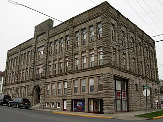
The Lottie Roth Block is an historic commercial building located near downtown Bellingham, Washington and is listed on the U.S. National Register of Historic Places. Built by quarry manager and Washington State Legislator Charles Roth and named after his wife, Lottie, the building is clad in the famous Chuckanut Sandstone from his Bellingham Bay Quarry that would be used in countless building projects across the region. Completed in 1891, it was one of the last large commissions of noted Northwest architect Elmer H. Fisher and his only project in Whatcom County. While initially built as an office/retail building in anticipation of the commercial expansion of the town of Whatcom, it was converted entirely to apartments by 1912 when commercial development moved in the opposite direction towards New Whatcom, which after 1903 became the new city of Bellingham's downtown. Still strictly serving as a residential building to the current day, the Lottie Roth Block was listed on the National Register of Historic Places on December 12, 1978.
John Joseph Donovan was a Washington State pioneer and the president of the state Chamber of Commerce, as well as one of the key founders of the City Council of Bellingham, Washington. During his life, Donovan actively participated in political, industrial, and commercial activity on city, county, and state levels. Several historic landmarks exist in Bellingham honoring J. J. Donovan, including his house, which was added to the National Historic Register, and a bronze statue installed in Fairhaven, Washington.
Old Main is a historic building on the Western Washington University campus in Bellingham, Washington. Constructed in 1896 to house the new Normal school and opened for classes in 1899, it is the oldest building on the campus. It currently serves as administrative and student services offices.