
Victoria, also known among the native Maltese as Rabat or by its title Città Victoria, is an administrative unit of Malta, and the main town on Gozo. Victoria has a total population of 6,901, and is the most populous settlement in Gozo.
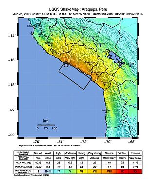
The 2001 southern Peru earthquake occurred at 20:33:15 UTC on June 23 with a moment magnitude of 8.4 and a maximum Mercalli intensity of XII (Extreme). The quake affected the Peruvian regions of Arequipa, Moquegua and Tacna. It was the most devastating earthquake in Peru since the catastrophic 1970 Ancash earthquake and globally the largest earthquake since the 1965 Rat Islands earthquake.

Maltese architecture has its origins in prehistory, and some of the oldest free-standing structures on Earth – a series of megalithic temples – can be found on Malta. The islands were colonized by the Phoenicians and later the Romans, who established the cities of Melite and Gaulos. Although these were substantial settlements and are known to have had numerous temples, churches and palaces, few remains have survived apart from some architectural fragments.
This page list topics related to Malta.

The Metropolitan Cathedral of Saint Paul, commonly known as St Paul's Cathedral or the Mdina Cathedral, is a Catholic cathedral in Mdina, Malta, dedicated to St. Paul the Apostle. The cathedral was founded in the 12th century, and according to tradition it stands on the site where Roman governor Publius met St. Paul following his shipwreck on Malta. The original cathedral was severely damaged in the 1693 Sicily earthquake, so it was dismantled and rebuilt in the Baroque style to a design of the Maltese architect Lorenzo Gafà between 1696 and 1705. The cathedral is regarded as Gafà's masterpiece.
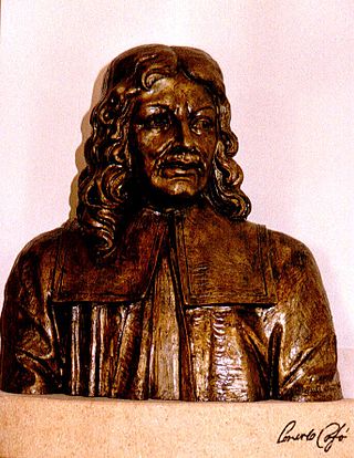
Lorenzo Gafà (1639–1703) was a Maltese Baroque architect and sculptor. He designed many churches in the Maltese Islands, including St. Paul's Cathedral in Mdina and the Cathedral of the Assumption in Victoria, Gozo. He was the younger brother of the sculptor Melchiorre Cafà.

The 1693 Sicily earthquake struck parts of southern Italy near Sicily, then a territory part of the Crown of Aragon by the Kings of Spain Calabria, and Malta on 11 January at around 21:00 local time. This earthquake was preceded by a damaging foreshock on 9 January. The main quake had an estimated magnitude of 7.4 on the moment magnitude scale, the most powerful in Italian recorded history, and a maximum intensity of XI (Extreme) on the Mercalli intensity scale, destroying at least 70 towns and cities, seriously affecting an area of 5,600 square kilometres (2,200 sq mi) and causing the death of about 60,000 people.

The Cathedral of the Assumption of the Blessed Virgin Mary into Heaven is a Roman Catholic cathedral in the Cittadella of Victoria in Gozo, Malta. The cathedral is dedicated to the Assumption of Mary, and has been the seat of the Roman Catholic Diocese of Gozo since the formation of the diocese in 1864.

Canon Giovanni Pietro Francesco Agius de Soldanis, often called de Soldanis, was a Maltese linguist, historian and cleric from the island of Gozo. He wrote the first lexicon and systematic grammar of the Maltese language, and he was the first librarian of the Bibliotheca Publica, the precursor of the National Library of Malta.
The 1382 Dover Straits earthquake occurred at 15:00 on 21 May. It had an estimated magnitude of 6.0 and a maximum felt intensity of VII–VIII on the Mercalli intensity scale. Based on contemporary reports of damage, the epicentre is thought to have been in the Strait of Dover. The earthquake caused widespread damage in south-eastern England and in the Low Countries. The earthquake interrupted a synod in London that convened in part to examine the religious writings of John Wycliffe, which became known as the Earthquake Synod.
The 1907 Sumatra earthquake occurred on January 4 at 05:19:12 UTC. The re-estimated moment magnitude (Mw) is 8.2 to 8.4, with an epicentre close to Simeulue, off Sumatra. An earlier study re-estimated a surface-wave magnitude (Ms) of 7.5 to 8.0. It triggered a widespread and damaging Indian Ocean wide tsunami that caused at least 2,188 deaths on Sumatra. The low observed intensity compared to the size of the tsunami has led to its interpretation as a tsunami earthquake. Higher levels of shaking observed on Nias are attributed to a large aftershock, less than an hour later. The tsunami gave rise to the S'mong legend, which is credited with saving many lives during the 2004 earthquake.
The 1912 Maymyo earthquake or Burma earthquake struck Burma on the morning of May 23, with an epicentre near Taunggyi and Pyin Oo Lwin in Shan State. The earthquake was initially calculated at 8.0 on the surface wave magnitude scale (Ms ) by Beno Gutenberg and Charles Francis Richter, and described by them as being one of the most remarkable seismic events in the early 1900s. Recent re-evaluation of the earthquake, however, have revised the magnitude to 7.6–7.9. It was preceded by two foreshocks on May 18 and 21 with respective intensities V and VII on the Rossi–Forel scale, while the mainshock was assigned IX. Shaking was felt throughout most of Burma, parts of Siam and Yunnan; an area covering approximately 375,000 square miles. It was one of the largest earthquakes in the country.
The 1856 Heraklion earthquake, also known as the Crete earthquake or Rhodes earthquake, occurred on the morning of October 12 at 02:45 am local time. This extremely catastrophic earthquake had an estimated magnitude of 7.7 to 8.3 at a depth of approximately 61 to 100 km. The earthquake was felt over a very wide area extending from Sicily, Italy to the Levant and North Africa. On the Greek island of Crete, the effects of the earthquake were cataclysmic, over 500 bodies were recovered in the city of Heraklion. Shockwaves from the earthquake were felt intensely, covering all of the Ottoman Empire; present-day Turkey, Cyprus and the Middle East where damage and human losses were reported. In Malta, the Għajn Ħadid Tower—a coastal watchtower built around the year 1638—was severely damaged in the earthquake, when its upper floor collapsed. In Cairo, Egypt, the earthquake destroyed buildings, created seiches in canals, and killed several people. Off the Egyptian and Italian coasts, sailors reported feeling a seaquake.

The 1626 Lingqiu earthquake had an epicentre in Lingqiu County, Shanxi Province during the Ming dynasty. The estimated surface wave magnitude (Ms ) 7.0 earthquake caused many buildings to collapse. Over 5,200 people were killed.
The 1743 Salento earthquake affected the Apulian region of southwestern Italy on 20 February at 23:30 IST. The ~7.1 Mw earthquake had an epicenter in the Adriatic and Ionian seas, off the coast of modern-day Lecce and Brindisi provinces in Salento. It had a maximum Modified Mercalli intensity of IX (Violent), causing heavy damage in Nardò. Damage was also reported across the sea, in the Balkans. The earthquake also generated a tsunami of up to 11 meters in run-up. Between 180 and 300 people were killed in the disaster.
The 1804 Almería earthquake was a highly destructive seismic event in the Province of Almería, southern Spain. It occurred on 25 August at 8:25 pm local time. The mainshock had a maximum intensity assigned VIII–IX on the European macroseismic scale (EMS), and an estimated moment magnitude of 6.2–6.4 Mw . At least 400 people were reported killed.
The 1882 Panama earthquake occurred on September 7 at around 03:50 (UTC-5). The earthquake measured a magnitude between 7.9 and 8.3 on the surface-wave magnitude scale, making it the largest earthquake recorded in Panamanian history. It struck the San Blas Islands and was strongly felt in the City of Colón as well as the capital of Panama City. The earthquake also produced a major tsunami that had a maximum run-up of 3 meters. In total, the earthquake killed 250 people, 75 of which were from the tsunami. The earthquake and tsunami also halted the construction of the Panama Canal by a few months.
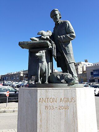
Anton Agius (1933-2008) was a Maltese sculptor, best known for creating a large number of monuments around Malta. He was dubbed "the national sculptor" by former Maltese president Ugo Mifsud Bonnici.

On 19 September 2022, a moment magnitude 7.6-7.7 earthquake struck between the Mexican states of Michoacán and Colima at 13:05:06 local time. The earthquake had a depth of 26.9 km (16.7 mi), resulting in a maximum intensity of VIII (Severe) on the Modified Mercalli intensity scale. The USGS reported the epicentre was 35 km (22 mi) southwest of the town of Aquila. Two people were killed and at least 35 others were injured across several states. A magnitude 6.8 aftershock struck on 22 September, causing three more deaths.


