Fort Chambray

Last updated • 8 min readFrom Wikipedia, The Free Encyclopedia
Fort Chambray
Forti Chambray
Mġarr, Gozo, Malta
Sudika Fort Chambray panorama.jpg
Fort Chambray viewed from the landward side
Fort Chambray map.png
Map of Fort Chambray
Coordinates 36°01′21″N14°17′40″E / 36.02250°N 14.29444°E / 36.02250; 14.29444
TypeBastioned fort
Site information
Owner Government of Malta
Controlled byFort Chambray Ltd
Open to
the public
No
ConditionIntact
Website www.fortchambray.com
Site history
Built1749–1760s
Built by Order of Saint John
In use1760s–1916
Materials Limestone
Battles/wars French invasion of Malta (1798)

Fort Chambray or Fort Chambrai (Maltese : Forti Xambrè) [1] is a bastioned fort located in the precincts of Għajnsielem, on the island of Gozo, Malta. It was built in the mid-18th century by the Order of Saint John, in an area known as Ras it-Tafal, between the port of Mġarr and Xatt l-Aħmar. The fort was meant to be the citadel of a new city which was to replace the Cittadella as the island's capital, but this plan never materialized.

Contents

The fort saw use during the French invasion of Malta in 1798, and was subsequently used as a military hospital and mental institution. The fort is currently being restored and redeveloped as a luxury accommodation. [2]

History

Background and construction

The fort was financed by and named after Jacques-Francois de Chambray Dechambray.jpg
The fort was financed by and named after Jacques-François de Chambray

Fort Chambray is located on Ras it-Tafal, on high ground overlooking Mġarr Harbour. The area was defended by Garzes Tower, which was built in 1605, and a coastal battery built in the early 18th century. The tower and the battery were demolished, and no remains have survived. [3]

In 1716, the French military engineer Louis François d'Aubigné de Tigné prepared plans for the construction of a fortified town at Ras it-Tafal. The Commissioners of Fortifications and War recommended constructing this proposed fort in a 1722 report, since it would be able to maintain the sea link with Malta, and would be able to take in Gozo's inhabitants and their livestock, relieving pressure from the Cittadella. However, construction was postponed indefinitely due to lack of funding. [4]

Curtain wall between the main gate (left) and St. Paul Bastion Fort Chambray 2.JPG
Curtain wall between the main gate (left) and St. Paul Bastion

In 1749, the new Governor of Gozo, Jacques-François de Chambray, informed Grand Master Manuel Pinto da Fonseca that he would pay for the construction of Tigné's proposed fort. The Congregation of Fortifications and War accepted the offer on 15 September, and sent the military engineer Francesco Marandon to survey the site. The latter made a few modifications to Tigné's original design, and construction of the fort began later in September 1749 under his supervision. [4] Almost 200 workmen were employed for the construction of the fort. [5]

Throughout the course of construction, a number of problems came up, including structural issues, a shortage of manpower, and the disobedience of workers. [6] Excavation of the ditches and the initial stages of construction were largely complete by June 1752, and work on the fort proper began in October of the same year. The fort was almost ready by 1757, and it was fully completed in the early 1760s. The fort quickly fell into disrepair, being described as a ruin in 1789. Some minor repair works were carried out in 1796. [4] The site was used as a temporarily prison by the law enforcers. [7]

Once the fort was built, a rectilinear street pattern was laid out so the town could be constructed within the walls, as had been originally planned by Tigné. However, the plots were not purchased and the town never developed, [4] mainly because the threat from the Ottoman Empire or the Barbary pirates had subsided, so Gozitans felt safe living in rural areas. [8]

Plans for its development drawn in the 1750s show that there had to be a militarized Baroque town with a grid plan, similar to Valletta, and residences were to include their own private gardens. A large space in the middle was intended to be a piazza or town square, surrounded by the main buildings. The buildings at the piazza were to include the main church, a courthouse and the residence of the Castellan. These buildings were to have a shared symmetrical late Baroque portico, and a place d’armes was to be in the whereabouts. [9] A number of farmhouses were built inside and outside the fort. [10]

French invasion and occupation

Fort Chambray saw its first use during the French invasion of Malta in June 1798. [11] [12] When the French landed on Gozo, many inhabitants took refuge within Chambray, bringing their livestock with them. [11] [12] At the time, the fort was commanded by the knight de Megrigny, [12] and it was armed with 72 pieces of artillery. [13] The fort initially offered some resistance, but it capitulated after the French General Jean Reynier posted three companies in front of the fort, and issued a proclamation ordering its garrison to surrender. [11] [13] The Gozitans who had taken refuge returned to their homes with their cattle. [11] [13]

Following its capture, Fort Chambray was manned by a French garrison. On 3 September, a day after the Maltese uprising began in Mdina, the Gozitans revolted against the French, and quickly took over the island except for Fort Chambray and the Cittadella. On 28 October 1798, Gozitan rebels led by Saverio Cassar and British marines led by Captain Cresswell attacked the fort, and it capitulated on the following day. [12] Other, probably more reliable, sources say that Fort Chambray was abandoned by French soldiers during the night of 16 and 17 September. [14]

British rule

Barrack block within the fort Fort Chambray 3.JPG
Barrack block within the fort

Malta and Gozo came under British rule in the beginning of the 19th century, and as a result Fort Chambray was taken over by a British garrison. By 1830, a small military hospital of four wards had been established within the fort. The hospital was expanded during the Crimean War, and hundreds of wounded soldiers were treated there. [15] The hospital was subsequently used by both the British military and Maltese civilians when there were fever epidemics. [16]

With the outbreak of the Anglo-Egyptian War in 1882, a large building which had previously been barracks was converted to a hospital in order to house casualties from the war. It was used as a Convalescent Depot during World War I, and thousands of ill or wounded patients passed through the hospital between October 1915 and its closure in March 1916. During this period, the medical staff issued a journal called The Fort Chambray Gazette. [16]

The military gave up the fort in 1916, and from 1934 to 1983 it was used as a civilian mental hospital, housing up to 200 patients. A section of the fort was also used as a leprosarium between 1937 and 1956, under the name of Sacred Heart Hospital. [16]

Throughout the years that the fort was used as a hospital, three cemeteries were built, one within the fort and two in the ditches. [17]

Recent history

The tombstones amongst construction waste and dilapidation Forti Xambre 02.jpg
The tombstones amongst construction waste and dilapidation
Modern developments within Fort Chambray Fort Chambray 4.JPG
Modern developments within Fort Chambray

In 1979, part of the fort began to be converted into a tourist complex, a project which never materialized. The Garrison Cemetery was cleared in the mid-1980s, and the human remains were transferred to the Santa Maria Cemetery in Xewkija on 1 July 1991. The tombstones have been set aside in a secluded part of the fort. The destruction of this cemetery has been called an "act of cultural vandalism". [16]

In January 1992, the Planning Services Division of the Ministry for Development of Infrastructure published the Fort Chambray Development Brief, in which it detailed that the fort should be redeveloped, while retaining the outer bastions, the barracks, bakeries, chapels and hospital complex. The brief also said that the tombstones from the cemetery should be used imaginatively in a landscaping scheme. [18]

The interior of the fort began to be redeveloped in January 1993. [19] A Master Plan was approved in 1995, and its owners took over the site in 2007. Since then, residential units have been built within the fort, and some of the bastions have been restored. A new Master Plan for phases two and three of the development was approved in 2012. [20] It is now closed to the general public as it serves as a gated community. [21]

Layout

Fort Chambray as seen from Mgarr Harbour Fort Chambray Ghajnsielem Gozo Malta 2014 2.jpg
Fort Chambray as seen from Mġarr Harbour

Fort Chambray consists of four main parts: a bastioned land front and its outworks, two flanks overlooking Mġarr Harbour and Xatt l-Aħmar, and a cliff face facing the sea.[ citation needed ]

The land front consists of three bastions:

The bastions are linked together by curtain walls, one of which contains the fort's main gate. [25] [26] They are protected by a ditch [27] and the following outworks:

The cliff face which makes up the fort's southern perimeter Fort Chambray 0001.jpg
The cliff face which makes up the fort's southern perimeter

The fort's western flank, overlooking Xatt l-Aħmar, mainly consists of a curtain wall which was originally protected by a ditch, [32] and the Guardian Angel Bastion, a pentagonal bastion at the southernmost part of the fort. It has five embrasures and a barbette parapet, a flat-roofed echaugette, [33] and a polverista with a conical roof. [34]

The fort's eastern flank, overlooking Mġarr Harbour, consists of an irregular trace linking Notre Dame Bastion to the cliff face, [35] which makes up the entire southern perimeter of the fort, overlooking the Gozo Channel. Two traverses are located at the centre of the cliff face. [36]

Further reading

Related Research Articles

<span class="mw-page-title-main">Fort Ricasoli</span> Historic fort on Malta

Fort Ricasoli is a bastioned fort in Kalkara, Malta, which was built by the Order of Saint John between 1670 and 1698. The fort occupies a promontory known as Gallows' Point and the north shore of Rinella Bay, commanding the entrance to the Grand Harbour along with Fort Saint Elmo. It is the largest fort in Malta and has been on the tentative list of UNESCO World Heritage Sites since 1998, as part of the Knights' Fortifications around the Harbours of Malta.

<span class="mw-page-title-main">Fort Manoel</span> Star fort in Gzira, Malta

Fort Manoel is a star fort on Manoel Island in Gżira, Malta. It was built in the 18th century by the Order of Saint John, during the reign of Grand Master António Manoel de Vilhena, after whom it is named. Fort Manoel is located to the north west of Valletta, and commands Marsamxett Harbour and the anchorage of Sliema Creek. The fort is an example of Baroque architecture, and was designed with both functionality and aesthetics in mind.

<span class="mw-page-title-main">Fort Saint Elmo</span> Star fort in Valletta, Malta

Fort Saint Elmo is a star fort in Valletta, Malta. It stands on the seaward shore of the Sciberras Peninsula that divides Marsamxett Harbour from Grand Harbour, and commands the entrances to both harbours along with Fort Tigné and Fort Ricasoli. It is best known for its role in the Great Siege of Malta in 1565.

Charles François de Mondion was a French architect and military engineer who was active in Hospitaller Malta in the early 18th century. He was also a member of the Order of Saint John.

<span class="mw-page-title-main">Għajnsielem</span> Local council in Gozo Region, Malta

Għajnsielem, meaning "Spring of Sielem", is a municipality on the southeastern coast of the island of Gozo in Malta, including the entire island of Comino. It has a population of 3,200 residents, and is the first Gozitan village that greets the visitor on leaving Mġarr Harbour towards the Gozitan heartland. Its name originated from the water spring, around which in 1700, Grandmaster Perellos built an arcade containing public wash basins and fresh water spouts. Attractions include Lourdes Chapel with its sharp steeple and underlying niche of Our Lady of Lourdes, Fort Chambray and the towering of Ghajnsielem Parish Church.

<span class="mw-page-title-main">Cottonera Lines</span> Line of fortifications in Malta

The Cottonera Lines, also known as the Valperga Lines, are a line of fortifications in Bormla and Birgu, Malta. They were built in the 17th and 18th centuries on higher ground and further outwards than the earlier line of fortifications, known as the Santa Margherita or Firenzuola lines, which also surround Bormla.

<span class="mw-page-title-main">Floriana Lines</span> Line of fortifications in Floriana, Malta

The Floriana Lines are a line of fortifications in Floriana, Malta, which surround the fortifications of Valletta and form the capital city's outer defences. Construction of the lines began in 1636 and they were named after the military engineer who designed them, Pietro Paolo Floriani. The Floriana Lines were modified throughout the course of the 17th and 18th centuries, and they saw use during the French blockade of 1798–1800. Today, the fortifications are still largely intact but rather dilapidated and in need of restoration.

<span class="mw-page-title-main">Cittadella (Gozo)</span> Citadel in Victoria, Gozo, Malta

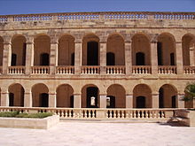
The Citadel, also known as the Castello, is the citadel of Victoria on the island of Gozo, Malta. The area has been inhabited since the Bronze Age, and the site now occupied by the Cittadella is believed to have been the acropolis of the Punic-Roman city of Gaulos or Glauconis Civitas.

<span class="mw-page-title-main">Gozo</span> Island of the Maltese archipelago in the Mediterranean Sea

Gozo, in antiquity known as Gaulos, is an island in the Maltese archipelago in the Mediterranean Sea. The island is part of the Republic of Malta. After the island of Malta itself, it is the second-largest island in the archipelago.

<span class="mw-page-title-main">Mġarr, Gozo</span>

Mġarr is a harbour town in south-eastern Gozo, Malta.

<span class="mw-page-title-main">Gozo (1798–1800)</span> Unrecognised state of Gozo (1798–1801)

The Gozitan Nation, commonly known as Gozo, was an unrecognised state located on the island of Gozo between 1798 and 1801 during the French Revolutionary Wars. It was a monarchy recognizing the authority of Ferdinand III of Sicily with a provisional government led by Governor-General Saverio Cassar. Its capital was Rabat. The country was established between 28 and 29 October 1798 from the territory of French-occupied Malta and was eventually incorporated into Malta Protectorate on 20 August 1801.

<span class="mw-page-title-main">Garzes Tower</span>

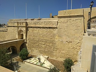
Garzes Tower, also known as Saint Martin's Tower, was a watchtower built in Mġarr, Gozo by the Order of Saint John in 1605. It was named after Martin Garzez, the Grand Master who financed its construction, even though it was eventually built after his death during the Magistry of Alof de Wignacourt. The tower was demolished in the 19th century; some remains were reused for the building of a bridge, and the site was developed with a hotel.

<span class="mw-page-title-main">Fortifications of Malta</span> Defensive military constructions of the Maltese archipelago

The fortifications of Malta consist of a number of walled cities, citadels, forts, towers, batteries, redoubts, entrenchments and pillboxes. The fortifications were built over hundreds of years, from around 1450 BC to the mid-20th century, and they are a result of the Maltese islands' strategic position and natural harbours, which have made them very desirable for various powers.

<span class="mw-page-title-main">Santa Margherita Lines</span> Line of fortifications in Cospicua, Malta

The Santa Margherita Lines, also known as the Firenzuola Lines, are a line of fortifications in Cospicua, Malta. They were built in the 17th and 18th centuries to protect the land front defences of the cities of Birgu and Senglea. A second line of fortifications, known as the Cottonera Lines, was later built around the Santa Margherita Lines, while the city of Cospicua was founded in the 18th century within the Santa Margherita and Cottonera Lines.

<span class="mw-page-title-main">Fortifications of Valletta</span> Defensive walls in Valletta, Malta

The fortifications of Valletta are a series of defensive walls and other fortifications which surround Valletta, the capital city of Malta. The first fortification to be built was Fort Saint Elmo in 1552, but the fortifications of the city proper began to be built in 1566 when it was founded by Grand Master Jean de Valette. Modifications were made throughout the following centuries, with the last major addition being Fort Lascaris which was completed in 1856. Most of the fortifications remain largely intact today.

<span class="mw-page-title-main">Fortifications of Mdina</span> Defensive walls in Mdina, Malta

The fortifications of Mdina are a series of defensive walls which surround Mdina, the former capital city of Malta from antiquity to the medieval period. The city was founded as Maleth by the Phoenicians in around the 8th century BC, and it later became part of the Roman Empire under the name Melite. The ancient city was surrounded by walls, but very few remains of these have survived.

<span class="mw-page-title-main">Fortifications of Birgu</span>

The fortifications of Birgu are a series of defensive walls and other fortifications which surround the city of Birgu, Malta. The first fortification to be built was Fort Saint Angelo in the Middle Ages, and the majority of the fortifications were built between the 16th and 18th centuries by the Order of Saint John. Most of the fortifications remain largely intact today.

<span class="mw-page-title-main">Fortifications of Senglea</span>

The fortifications of Senglea are a series of defensive walls and other fortifications which surround the city of Senglea, Malta. The first fortification to be built was Fort Saint Michael in 1552, and the majority of the fortifications were built over the next decade when it was founded by Grand Master Claude de la Sengle. Modifications continued until the 18th century, but large parts of the fortifications were demolished between the 19th and 20th centuries. Today, all that remain of Senglea's fortifications are the seaward bastions and part of the land front.

<span class="mw-page-title-main">Gozo boat</span> Settee-rigged boat originating from Malta

The Gozo boat was a type of settee-rigged boat originating from Malta. Gozo boats were the main means of transport across the Gozo Channel between Gozo and the main island of Malta from the late 19th to the mid-20th century. The design of the boats developed from the speronara.

<span class="mw-page-title-main">French invasion of Malta</span> 1798 invasion, part of the Mediterranean campaign

The French invasion of Malta was the successful invasion of the islands of Malta and Gozo, then ruled by the Order of St. John, by the French First Republic led by Napoleon Bonaparte in June 1798 as part of the Mediterranean campaign of the French Revolutionary Wars.

References

  1. "Malta bil chzejer tehne u li ghadda min ghaliha: It-tieni parti". 25 June 1865 via Google Books.
  2. Scicluna, Joseph. "Bidu ©did g ̇al Chambray" (PDF). www.um.edu.mt. Retrieved 2020-07-07.
  3. Spiteri, Stephen C. (2013). "In Defence of the Coast (I) – The Bastioned Towers". Arx – International Journal of Military Architecture and Fortification (3): 10. Retrieved 22 March 2016.
  4. 1 2 3 4 Buhagiar, Konrad; Cassar, JoAnn (2003). "Fort Chambray: The genesis and realization of a project in eighteenth-century Malta" (PDF). Melita Historica. 13 (4): 347–364. Archived from the original (PDF) on 22 March 2016.
  5. "Baroque routes" (PDF). www.um.edu.mt. 2007. Archived from the original (PDF) on 2015-12-14. Retrieved 2020-04-05.
  6. Cremona, John (2013). "The fortification that never became a city". GWL (4/13). Wirt Għawdex: 2. Archived from the original on 22 March 2016.
  7. R.M.B. (1934). "Sika Trid Tizzewweg..." (PDF). Il-Malti (in Maltese). 10 (2): 78–80. Archived from the original (PDF) on 3 July 2019.
  8. "Fort Chambrai". Visit Gozo. Archived from the original on 13 March 2016.
  9. Zammit, Ninu (22 November 2007). "Vauban and French Architecural Influence in Malta". Department of Information (1795). Valletta, Malta. Archived from the original on 29 March 2017.
  10. Cauchi, Kevin (June 2014). "'Hain Selem' - The Village that Flourished around a Spring" (PDF). The Gozo Observer (30): 26–31.
  11. 1 2 3 4 Cassar Pullicino, J. (1954). "Alcuni documenti inediti intorno al Gozo, 1798-1818" (PDF). Malta Letteraria. 3 (2): 84–86. Archived from the original (PDF) on 16 April 2016.
  12. 1 2 3 4 Castillo, Dennis Angelo (2006). The Maltese Cross: A Strategic History of Malta. Westport: Greenwood Publishing Group. pp. 103, 120. ISBN   9780313323294.
  13. 1 2 3 Porter, Whitworth (1871). Malta and Its Knights. Pardon and Son. pp. 299–300.
  14. "p. 70" (PDF).
  15. "HISTORIA HOSPITALIUM" (PDF). www.um.edu.mt. Retrieved 2020-04-05.
  16. 1 2 3 4 "Fort Chambray – Gozo". Malta Family History. Archived from the original on 3 March 2016.
  17. Scerri, John. "Cemeteries". malta-canada.com. Archived from the original on 7 March 2016.
  18. "Fort Chambray Development Brief". Planning Services Division. January 1992. Archived from the original on 24 September 2016.
  19. "Photos catalogue" (PDF). National Archives of Malta – Gozo Section. Archived from the original (PDF) on 23 March 2013.
  20. "Thumbs up for new Fort Chambray Master Plan". The Malta Independent . 23 November 2012. Archived from the original on 15 July 2014.
  21. Xuereb, Mariella (2008). "Forti Chambray Meravilja tal-Kavallieri ta' San Ìwann" (PDF). www.um.edu.mt. Retrieved 2020-07-07.
  22. "St Anthony Bastion – Fort Chambrai" (PDF). National Inventory of the Cultural Property of the Maltese Islands. 28 June 2013. Retrieved 14 July 2015.[ dead link ]
  23. "St Paul Bastion – Fort Chambrai" (PDF). National Inventory of the Cultural Property of the Maltese Islands. 28 June 2013. Retrieved 14 July 2015.[ dead link ]
  24. "Notre Dame Bastion – Fort Chambrai" (PDF). National Inventory of the Cultural Property of the Maltese Islands. 28 June 2013. Archived from the original (PDF) on July 14, 2015. Retrieved 14 July 2015.
  25. "Curtain wall with main entrance – Fort Chambrai" (PDF). National Inventory of the Cultural Property of the Maltese Islands. 28 June 2013. Archived from the original (PDF) on July 15, 2015. Retrieved 14 July 2015.
  26. "Curtain wall linking St Anthony Bastion to St Paul Bastion – Fort Chambrai" (PDF). National Inventory of the Cultural Property of the Maltese Islands. 28 June 2013. Archived from the original (PDF) on July 15, 2015. Retrieved 14 July 2015.
  27. "Ditch – Fort Chambrai" (PDF). National Inventory of the Cultural Property of the Maltese Islands. 28 June 2013. Archived from the original (PDF) on July 14, 2015. Retrieved 14 July 2015.
  28. "Central Countergaurd – Fort Chambrai" (PDF). National Inventory of the Cultural Property of the Maltese Islands. 28 June 2013. Archived from the original (PDF) on July 15, 2015. Retrieved 14 July 2015.
  29. "Right Ravelin – Fort Chambrai" (PDF). National Inventory of the Cultural Property of the Maltese Islands. 28 June 2013. Archived from the original (PDF) on July 15, 2015. Retrieved 14 July 2015.
  30. "Left Ravelin – Fort Chambrai" (PDF). National Inventory of the Cultural Property of the Maltese Islands. 28 June 2013. Archived from the original (PDF) on July 15, 2015. Retrieved 14 July 2015.
  31. "Covertway – Fort Chambrai" (PDF). National Inventory of the Cultural Property of the Maltese Islands. 28 June 2013. Archived from the original (PDF) on July 14, 2015. Retrieved 14 July 2015.
  32. "Curtain wall linking St Anthony Bastion to Guardian Angel Bastion – Fort Chambrai" (PDF). National Inventory of the Cultural Property of the Maltese Islands. 28 June 2013. Archived from the original (PDF) on July 15, 2015. Retrieved 14 July 2015.
  33. "Guardian Angel Bastion – Fort Chambrai" (PDF). National Inventory of the Cultural Property of the Maltese Islands. 28 June 2013. Archived from the original (PDF) on July 14, 2015. Retrieved 14 July 2015.
  34. "Polverista – Fort Chambrai" (PDF). National Inventory of the Cultural Property of the Maltese Islands. 28 June 2013. Archived from the original (PDF) on July 15, 2015. Retrieved 14 July 2015.
  35. "Mġarr facing front – Fort Chambrai" (PDF). National Inventory of the Cultural Property of the Maltese Islands. 28 June 2013. Archived from the original (PDF) on July 14, 2015. Retrieved 14 July 2015.
  36. "Cliff face – Fort Chambrai" (PDF). National Inventory of the Cultural Property of the Maltese Islands. 28 June 2013. Archived from the original (PDF) on July 14, 2015. Retrieved 14 July 2015.