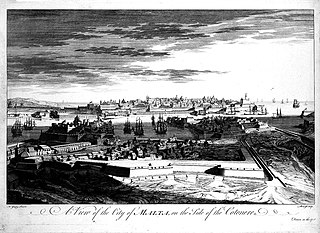
Floriana Lines

Last updated

Floriana Lines
Is-Swar tal-Furjana
Floriana, Malta
Floriana lines 05.jpg
San Salvatore Bastion and Counterguard
Floriana Lines map.png
Map of the Floriana Lines
Malta location map.svg
Red pog.svg
Floriana
Coordinates 35°53′26″N14°30′8″E / 35.89056°N 14.50222°E / 35.89056; 14.50222
TypeLine of fortifications
Site information
Owner Government of Malta
ConditionMostly intact
Site history
Built1636–18th century
Built by Order of Saint John
In use1640–20th century
Materials Limestone
Battles/wars Siege of Malta (1798–1800)

The Floriana Lines (Maltese : Is-Swar tal-Furjana) are a line of fortifications in Floriana, Malta, which surround the fortifications of Valletta and form the capital city's outer defences. Construction of the lines began in 1636 and they were named after the military engineer who designed them, Pietro Paolo Floriani. The Floriana Lines were modified throughout the course of the 17th and 18th centuries, and they saw use during the French blockade of 1798–1800. Today, the fortifications are still largely intact but rather dilapidated and in need of restoration.

Contents

The Floriana Lines are considered to be among the most complicated and elaborate of the Hospitaller fortifications of Malta. [1] Since 1998, they have been on the tentative list of UNESCO World Heritage Sites, as part of the Knights' Fortifications around the Harbours of Malta. [2]

History

Background, controversy and construction

The city of Valletta was founded on 28 March 1566 by Jean de Valette, the Grand Master of the Order of St. John. The city occupied about half the Sciberras Peninsula, a large promontory separating the Grand Harbour from Marsamxett Harbour, and was protected by tracce italiane fortifications, including a land front with four bastions, two cavaliers and a deep ditch. [3] Although these fortifications were well designed, by the early 17th century they were not strong enough to resist a large attack due to new technological developments which increased the range of artillery. [1]

In 1634, there were fears that the Ottomans would attack Malta. Grand Master Antoine de Paule asked Pope Urban VIII for help in improving the island's fortifications. The Pope sent Pietro Paolo Floriani to examine the defences, who in 1635 proposed building a second line of fortifications around the Valletta Land Front. Some members of the Order and a number of military engineers strongly opposed these plans, since the large garrison needed to man the lines was deemed too expensive. [4] Eventually De Paule decided to construct the lines, since it would have been improper to disagree with the Pope's military engineer. The Bailiff Gattinara resigned from his post in the Commission of Fortifications in protest. [5]

Work on the lines began in 1636, [6] but no ceremony was carried out to commemorate laying the foundation stone due to controversy surrounding the construction. Since fortification was expensive, the new Grand Master Giovanni Paolo Lascaris imposed a new tax on immovable property. [7] This tax created dispute between the Order and the clergy, who protested to the Pope. Some priests also influenced the population to take part in a national protest, but plans leaked out to authorities and the leaders were arrested. [5]

The fortifications were named the Floriana Lines after their architect. [8] By June 1640, the lines were considered partially defensible, although still incomplete. [9]

Improvements and modifications

View of the Grand Harbour in c. 1725, with the Floriana Lines visible to the left Malta; view of the city. Etching by M-A. Benoist, c. 1770, a Wellcome L0019024.jpg
View of the Grand Harbour in c. 1725, with the Floriana Lines visible to the left
Floriana Lines as seen from Sa Maison Gardens Floriana Lines Gardjola.jpg
Floriana Lines as seen from Sa Maison Gardens

Fears of an Ottoman attack rose again after the fall of Candia in 1669, and the following year Grand Master Nicolas Cotoner invited the military engineer Antonio Maurizio Valperga to improve the fortifications. [10] At the time the Floriana Lines were still under construction, and a number of weak points had been identified in their original design, especially since the demi-bastions forming the two extremities of the land front were too acute and could not be well defended. Valperga attempted to correct these flaws by making a number of alterations to San Salvatore Bastion on the western end of the lines, and constructing a faussebraye around the entire land front and a crowned hornwork near the eastern end. [11] In the 1680s some minor modifications were made by the Flemish engineer Carlos de Grunenbergh. [1]

Work on Valperga's modifications to the lines progressed slowly, and by the beginning of the 18th century the outworks, glacis and enceinte facing Marsamxett were still unfinished. [11] Works continued under a number of other engineers, including Charles François de Mondion, and the lines were largely complete when Porte des Bombes was constructed in 1721. [8] Further alterations were made over the following decades, such as the construction of the Northern Entrenchment in the 1730s. [1]

In 1724, the suburb of Floriana was founded in the area between the Floriana Lines and the Valletta Land Front. [6] The suburb was named Borgo Vilhena after Grand Master António Manoel de Vilhena, but it was commonly known as Floriana. [8] It is now a town in its own right. [12]

French occupation and British rule

French forces invaded Malta in June 1798, and the Order capitulated after a couple of days. The French occupied the island until September, when the Maltese rebelled and blockaded the French forces in the harbour area with foreign help. The Floriana Lines remained under French control throughout the blockade, and the Maltese built Tas-Samra Battery and a battery on Corradino in order to bombard them. [13]

After the British took over Malta in 1800, the lines remained a functional military establishment. A number of minor alterations were made, including the enlargement of Porte des Bombes, the demolition of a lunette and some other gates, [14] and the addition of gunpowder magazines and traverses. [11]

Recent history

Section of the fortifications which was demolished and is now occupied by the Grand Hotel Excelsior Malta with gondolas.jpg
Section of the fortifications which was demolished and is now occupied by the Grand Hotel Excelsior

The fortifications were included on the Antiquities List of 1925, [15] and they are now also listed on the National Inventory of the Cultural Property of the Maltese Islands.

In the 1970s, parts of the covertway and glacis were destroyed to make way for large storage tanks. [11] Today, the lines are still more or less intact, but some parts are in a rather dilapidated state and in need of restoration. [16]

Layout

Land front

Faussebraye near St. Philip's Bastion Malta - Floriana - Triq Nazzjonali 03 ies.jpg
Faussebraye near St. Philip's Bastion

The Floriana Land Front is the large bastioned enceinte enclosing the landward approach to the Floriana. It consists of the following:

Porte des Bombes Malta - Floriana - Triq Nazzjonali - Porte des Bombes (N) 02 ies.jpg
Porte des Bombes

The land front is surrounded by a ditch, [26] which contains the following outworks:

The outworks are surrounded by a faussebraye, [32] advanced ditch, [33] covertway, [34] and glacis. [35] In the 1720s, a gate known as Porta dei Cannoni was built in the faussebraye. The gate was enlarged by the British, and became known as Porte des Bombes. It was eventually detached from the faussebraye to facilitate the flow of traffic, and it now looks like a triumphal arch. [36]

A crowned hornwork consisting of an inner hornwork with two demi-bastions [37] and an outer crownwork with one full bastion and two demi-bastions [37] is located near St. Francis Ravelin. The crownwork was protected by a musketry gallery overlooking Marsa [38] and by two lunettes, one near its land front [39] and another near its flank. [40]

Marsamxett enceinte

The enceinte along Marsamxett Harbour Malta - Floriana - Xatt it-Tiben 02 ies.jpg
The enceinte along Marsamxett Harbour
Msida Bastion Malta - Floriana - Triq Vincenzo Dimech (MSTHC) 01 ies.jpg
Msida Bastion

The enceinte along the side facing Marsamxett Harbour starts from San Salvatore Bastion of the Floriana Land Front, and originally ended at St. Michael's Counterguard of the Valletta Land Front. It consists of the following:

In addition, a bastioned enceinte known as the North Entrenchment is located behind the entire Marsamxett enceinte, acting as a secondary line of defence. [46]

Grand Harbour enceinte

Capuchin Bastion Malta - Floriana - Triq l-Ghassara tal-Gheneb+Capuchin Bastion (MSTHC) 02 ies.jpg
Capuchin Bastion

The enceinte along the side facing the Grand Harbour starts from St. Francis Bastion of the Floriana Land Front, and ends at St. Peter and St. Paul Counterguard of the Valletta Land Front. It consists of the following:

Related Research Articles

<span class="mw-page-title-main">Valletta</span> Capital of Malta

Valletta is an administrative unit and the capital of Malta. Located on the main island, between Marsamxett Harbour to the west and the Grand Harbour to the east, its population within administrative limits in 2014 was 6,444. According to the data from 2020 by Eurostat, the Functional Urban Area and metropolitan region covered the whole island and has a population of 480,134. Valletta is the southernmost capital of Europe, and at just 0.61 square kilometres (0.24 sq mi), it is the European Union's smallest capital city.

<span class="mw-page-title-main">Floriana</span> Local council in South Eastern Region, Malta

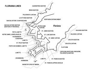
Floriana, also known by its title Borgo Vilhena, is a fortified town in the South Eastern Region area of Malta, just outside the capital city Valletta. It has a population of 2,205 as of March 2014. Floriana is the birthplace of many famous Maltese, amongst which the composer of the national anthem, 'L-Innu Malti', Robert Samut; former Bishop of Malta Dun Mauro Caruana, the poets Oliver Friggieri and Maria Grech Ganado, the writer and politician Herbert Ganado and Swedish Idol winner Kevin Borg.

<span class="mw-page-title-main">City Gate (Valletta)</span> Entrance to the city of Valletta, Malta

City Gate is a gate located at the entrance of Valletta, Malta. The present gate, which is the fifth one to have stood on the site, was built between 2011 and 2014 to designs of the Italian architect Renzo Piano.

<span class="mw-page-title-main">Fort Ricasoli</span> Historic fort on Malta

Fort Ricasoli is a bastioned fort in Kalkara, Malta, which was built by the Order of Saint John between 1670 and 1698. The fort occupies a promontory known as Gallows' Point and the north shore of Rinella Bay, commanding the entrance to the Grand Harbour along with Fort Saint Elmo. It is the largest fort in Malta and it has been on the tentative list of UNESCO World Heritage Sites since 1998, as part of the Knights' Fortifications around the Harbours of Malta.

<span class="mw-page-title-main">Fort Manoel</span> Star fort in Gzira, Malta

Fort Manoel is a star fort on Manoel Island in Gżira, Malta. It was built in the 18th century by the Order of Saint John, during the reign of Grand Master António Manoel de Vilhena, after whom it is named. Fort Manoel is located to the north west of Valletta, and commands Marsamxett Harbour and the anchorage of Sliema Creek. The fort is an example of Baroque architecture, and it was designed with both functionality and aesthetics in mind.

<span class="mw-page-title-main">Fort Saint Elmo</span> Star fort in Valletta, Malta

Fort Saint Elmo is a star fort in Valletta, Malta. It stands on the seaward shore of the Sciberras Peninsula that divides Marsamxett Harbour from Grand Harbour, and commands the entrances to both harbours along with Fort Tigné and Fort Ricasoli. It is best known for its role in the Great Siege of Malta in 1565.

Charles François de Mondion was a French architect and military engineer who was active in Hospitaller Malta in the early 18th century. He was also a member of the Order of Saint John.

<span class="mw-page-title-main">Cottonera Lines</span> Line of fortifications in Malta

The Cottonera Lines, also known as the Valperga Lines, are a line of fortifications in Bormla and Birgu, Malta. They were built in the 17th and 18th centuries on higher ground and further outwards than the earlier line of fortifications, known as the Santa Margherita or Firenzuola lines, which also surround Bormla.

<span class="mw-page-title-main">Cittadella (Gozo)</span> Citadel in Victoria, Gozo, Malta

The Citadel, also known as the Castello, is the citadel of Victoria on the island of Gozo, Malta. The area has been inhabited since the Bronze Age, and the site now occupied by the Cittadella is believed to have been the acropolis of the Punic-Roman city of Gaulos or Glauconis Civitas.

<span class="mw-page-title-main">Fort Chambray</span> Fortress in Malta

Fort Chambray or Fort Chambrai is a bastioned fort located in the precincts of Għajnsielem, on the island of Gozo, Malta. It was built in the mid-18th century by the Order of Saint John, in an area known as Ras it-Tafal, between the port of Mġarr and Xatt l-Aħmar. The fort was meant to be the citadel of a new city which was to replace the Cittadella as the island's capital, but this plan never materialized.

<span class="mw-page-title-main">Portes des Bombes</span> Gate in Floriana, Malta

Portes des Bombes, originally called Porta dei Cannoni, is an ornamental arched gate in Floriana, Malta. It was originally built in 1721 as an advanced gate within the faussebraye of the Floriana Lines, and it was enlarged with the construction of a second archway in 1868. The ramparts on either side of the gate have since been demolished, leaving the gate looking like a triumphal arch.

<span class="mw-page-title-main">Saint John's Cavalier</span>

Saint John's Cavalier is a 16th-century cavalier in Valletta, Malta, which was built by the Order of St. John. It overlooks St. John's Bastion, a large obtuse-angled bastion forming part of the Valletta Land Front. St. John was one of nine planned cavaliers in the city, although eventually only two were built, the other one being the identical Saint James Cavalier. It was designed by the Italian military engineer Francesco Laparelli, while its construction was overseen by his Maltese assistant Girolamo Cassar.

<span class="mw-page-title-main">Fortifications of Malta</span> Defensive military constructions of the Maltese archipelago

The fortifications of Malta consist of a number of walled cities, citadels, forts, towers, batteries, redoubts, entrenchments and pillboxes. The fortifications were built over hundreds of years, from around 1450 BC to the mid-20th century, and they are a result of the Maltese islands' strategic position and natural harbours, which have made them very desirable for various powers.

<span class="mw-page-title-main">Fort San Salvatore</span> Retrenched fort in Birgu, Malta

Fort San Salvatore, also known as Fort Salvatore, is a retrenched fort in Birgu, Malta. It was built in 1724 on one of the bastions of the Cottonera Lines. It was used as a prisoner-of-war camp during the Greek War of Independence and World War I, and as an internment camp and kerosene depot in World War II.

<span class="mw-page-title-main">Santa Margherita Lines</span> Line of fortifications in Cospicua, Malta

The Santa Margherita Lines, also known as the Firenzuola Lines, are a line of fortifications in Cospicua, Malta. They were built in the 17th and 18th centuries to protect the land front defences of the cities of Birgu and Senglea. A second line of fortifications, known as the Cottonera Lines, was later built around the Santa Margherita Lines, while the city of Cospicua was founded in the 18th century within the Santa Margherita and Cottonera Lines.

<span class="mw-page-title-main">Fortifications of Valletta</span> Defensive walls in Valletta, Malta

The fortifications of Valletta are a series of defensive walls and other fortifications which surround Valletta, the capital city of Malta. The first fortification to be built was Fort Saint Elmo in 1552, but the fortifications of the city proper began to be built in 1566 when it was founded by Grand Master Jean de Valette. Modifications were made throughout the following centuries, with the last major addition being Fort Lascaris which was completed in 1856. Most of the fortifications remain largely intact today.

<span class="mw-page-title-main">Fortifications of Mdina</span> Defensive walls in Mdina, Malta

The fortifications of Mdina are a series of defensive walls which surround the former capital city of Mdina, Malta. The city was founded as Maleth by the Phoenicians in around the 8th century BC, and it later became part of the Roman Empire under the name Melite. The ancient city was surrounded by walls, but very few remains of these have survived.

<span class="mw-page-title-main">Fortifications of Birgu</span>

The fortifications of Birgu are a series of defensive walls and other fortifications which surround the city of Birgu, Malta. The first fortification to be built was Fort Saint Angelo in the Middle Ages, and the majority of the fortifications were built between the 16th and 18th centuries by the Order of Saint John. Most of the fortifications remain largely intact today.

<span class="mw-page-title-main">Fortifications of Senglea</span>

The fortifications of Senglea are a series of defensive walls and other fortifications which surround the city of Senglea, Malta. The first fortification to be built was Fort Saint Michael in 1552, and the majority of the fortifications were built over the next decade when it was founded by Grand Master Claude de la Sengle. Modifications continued until the 18th century, but large parts of the fortifications were demolished between the 19th and 20th centuries. Today, all that remain of Senglea's fortifications are the seaward bastions and part of the land front.

<span class="mw-page-title-main">Carlos de Grunenbergh</span>

Carlos de Grunenbergh, also known as Carlo Grunenberg, was a Flemish architect and military engineer active in the late 17th century. He mainly designed fortifications in Sicily and Malta. He was also a member of the Order of Saint John.

References

  1. 1 2 3 4 5 Spiteri, Stephen C. (2004–2007). "The Development of the Bastion of Provence, Floriana Lines" (PDF). Arx – Online Journal of Military Architecture and Fortification (1–4): 24–32. Archived from the original (PDF) on 15 November 2015. Retrieved 15 July 2015.
  2. "Knights' Fortifications around the Harbours of Malta". UNESCO Tentative List. Retrieved 15 July 2015.
  3. "Valletta" (PDF). National Inventory of the Cultural Property of the Maltese Islands. 28 June 2013. Archived from the original (PDF) on 11 June 2015. Retrieved 5 November 2015.
  4. Stephenson, Charles (2004). The Fortifications of Malta 1530–1945 . Osprey Publishing. p.  16. ISBN   1841766933.
  5. 1 2 Zammit, Vincent (1984). "Seventeenth Century Fortifications". Civilization. 1. Ħamrun: PEG Ltd: 116–117.
  6. 1 2 Rix, Juliet (2013). Malta and Gozo. Bradt Travel Guides. p. 148. ISBN   9781841624525.
  7. Gaullaumier, Alfie (1987). Bliet u Rħula Maltin (in Maltese). Valletta: Valletta Publishing & Promotion Co. Ltd. p. 182.
  8. 1 2 3 "Introduction". Floriana Local Council. Archived from the original on 8 October 2015. Retrieved 4 October 2015.
  9. Adami, Giuseppe (1997). "FLORIANI, Pietro Paolo". Dizionario Biografico degli Italiani (in Italian). 48. Retrieved 11 November 2015.
  10. Vella, John (2007). "Antonio Maurizio Valperga" (PDF). Programm Tal-festa Marija Immakulata Fil-belt Ta' Bormla: 49–55.
  11. 1 2 3 4 5 "Floriana Lines – Floriana Lines" (PDF). National Inventory of the Cultural Property of the Maltese Islands. 28 June 2013. Archived from the original (PDF) on 13 April 2015. Retrieved 15 July 2015.
  12. "Floriana". lc.gov.mt. Archived from the original on 8 April 2016. Retrieved 4 October 2015.
  13. Spiteri, Stephen C. (May 2008). "Maltese 'siege' batteries of the blockade 1798–1800" (PDF). Arx – Online Journal of Military Architecture and Fortification (6): 21–25. Retrieved 15 July 2015.
  14. 1 2 "Gateways that have vanished: Porta Sant'Anna, Floriana & Porta Haynduieli, Cottonera". The Malta Independent . 29 April 2014. Retrieved 6 April 2015.
  15. "Protection of Antiquities Regulations 21st November, 1932 Government Notice 402 of 1932, as Amended by Government Notices 127 of 1935 and 338 of 1939". Malta Environment and Planning Authority . Archived from the original on 19 April 2016.
  16. "Tender for Restoration Works at the Malta Environment and Planning Authority". MEPA. 27 January 2015. pp. 50–54. Archived from the original on 28 March 2015.
  17. "San Salvatore Bastion – Floriana Lines" (PDF). National Inventory of the Cultural Property of the Maltese Islands. 28 June 2013. Archived from the original (PDF) on 16 July 2015. Retrieved 15 July 2015.
  18. "Notre Dame Curtain – Floriana Lines" (PDF). National Inventory of the Cultural Property of the Maltese Islands. 28 June 2013. Archived from the original (PDF) on 16 July 2015. Retrieved 15 July 2015.
  19. "Notre Dame Gate – Floriana Lines" (PDF). National Inventory of the Cultural Property of the Maltese Islands. 28 June 2013. Archived from the original (PDF) on 16 July 2015. Retrieved 15 July 2015.
  20. "St Philip Bastion – Floriana Lines" (PDF). National Inventory of the Cultural Property of the Maltese Islands. 28 June 2013. Archived from the original (PDF) on 16 July 2015. Retrieved 15 July 2015.
  21. "St James Bastion – Floriana Lines" (PDF). National Inventory of the Cultural Property of the Maltese Islands. 28 June 2013. Archived from the original (PDF) on 16 July 2015. Retrieved 15 July 2015.
  22. "St Luke Bastion" (PDF). National Inventory of the Cultural Property of the Maltese Islands. 28 June 2013. Archived from the original (PDF) on 16 July 2015. Retrieved 15 July 2015.
  23. "St Anne Curtain – Floriana Lines" (PDF). National Inventory of the Cultural Property of the Maltese Islands. 28 June 2013. Archived from the original (PDF) on 16 July 2015. Retrieved 15 July 2015.
  24. "St Francis Bastion – Floriana Lines" (PDF). National Inventory of the Cultural Property of the Maltese Islands. 28 June 2013. Archived from the original (PDF) on 16 July 2015. Retrieved 15 July 2015.
  25. "St Mark Bastion – Floriana Lines" (PDF). National Inventory of the Cultural Property of the Maltese Islands. 28 June 2013. Archived from the original (PDF) on 16 July 2015. Retrieved 15 July 2015.
  26. "Main ditch – Floriana Lines" (PDF). National Inventory of the Cultural Property of the Maltese Islands. 28 June 2013. Archived from the original (PDF) on 16 July 2015. Retrieved 15 July 2015.
  27. "San Salvatore Counterguard – Floriana Lines" (PDF). National Inventory of the Cultural Property of the Maltese Islands. 28 June 2013. Archived from the original (PDF) on 16 July 2015. Retrieved 15 July 2015.
  28. "Pieta Lunette – Floriana Lines" (PDF). National Inventory of the Cultural Property of the Maltese Islands. 28 June 2013. Archived from the original (PDF) on 16 July 2015. Retrieved 15 July 2015.
  29. "Notre Dame Ravelin – Floriana Lines" (PDF). National Inventory of the Cultural Property of the Maltese Islands. 28 June 2013. Archived from the original (PDF) on 16 July 2015. Retrieved 15 July 2015.
  30. "Lunette near Portes des Bombes – Floriana Lines" (PDF). National Inventory of the Cultural Property of the Maltese Islands. 28 June 2013. Archived from the original (PDF) on 16 July 2015. Retrieved 15 July 2015.
  31. "St Francis Ravelin – Floriana Lines" (PDF). National Inventory of the Cultural Property of the Maltese Islands. 28 June 2013. Archived from the original (PDF) on 16 July 2015. Retrieved 15 July 2015.
  32. "Faussebraye – Floriana Lines" (PDF). National Inventory of the Cultural Property of the Maltese Islands. 28 June 2013. Archived from the original (PDF) on 16 July 2015. Retrieved 15 July 2015.
  33. "Advanced ditch – Floriana Lines" (PDF). National Inventory of the Cultural Property of the Maltese Islands. 28 June 2013. Archived from the original (PDF) on 16 July 2015. Retrieved 15 July 2015.
  34. "Covered Way – Floriana Lines" (PDF). National Inventory of the Cultural Property of the Maltese Islands. 28 June 2013. Archived from the original (PDF) on 16 July 2015. Retrieved 15 July 2015.
  35. "Glacis – Floriana Lines" (PDF). National Inventory of the Cultural Property of the Maltese Islands. 28 June 2013. Archived from the original (PDF) on 16 July 2015. Retrieved 15 July 2015.
  36. "Porte des Bombes – Floriana Lines" (PDF). National Inventory of the Cultural Property of the Maltese Islands. 28 June 2013. Archived from the original (PDF) on 16 July 2015. Retrieved 15 July 2015.
  37. 1 2 "Crowned-hornworks – Floriana Lines" (PDF). National Inventory of the Cultural Property of the Maltese Islands. 28 June 2013. Archived from the original (PDF) on 16 July 2015. Retrieved 15 July 2015.
  38. "Musketry spur of Marsa" (PDF). National Inventory of the Cultural Property of the Maltese Islands. 28 June 2013. Archived from the original (PDF) on 16 July 2015. Retrieved 15 July 2015.
  39. "Lunette on land front of crownwork – Floriana Lines" (PDF). National Inventory of the Cultural Property of the Maltese Islands. 28 June 2013. Archived from the original (PDF) on 16 July 2015. Retrieved 15 July 2015.
  40. "Lunette near flank of Crownwork – Floriana Lines" (PDF). National Inventory of the Cultural Property of the Maltese Islands. 28 June 2013. Archived from the original (PDF) on 16 July 2015. Retrieved 15 July 2015.
  41. "La Vittoria Bastion – Floriana Lines" (PDF). National Inventory of the Cultural Property of the Maltese Islands. 28 June 2013. Archived from the original (PDF) on 16 July 2015. Retrieved 15 July 2015.
  42. "Polverista Curtain – Floriana Lines" (PDF). National Inventory of the Cultural Property of the Maltese Islands. 28 June 2013. Archived from the original (PDF) on 16 July 2015. Retrieved 15 July 2015.
  43. "Msida Bastion – Floriana Lines" (PDF). National Inventory of the Cultural Property of the Maltese Islands. 28 June 2013. Archived from the original (PDF) on 16 July 2015. Retrieved 15 July 2015.
  44. "Curtain Linking Quarantine Curtain to Msida Bastion – Floriana Lines" (PDF). National Inventory of the Cultural Property of the Maltese Islands. 28 June 2013. Archived from the original (PDF) on 16 July 2015. Retrieved 15 July 2015.
  45. "Quarantine Bastion – Floriana Lines" (PDF). National Inventory of the Cultural Property of the Maltese Islands. 28 June 2013. Archived from the original (PDF) on 16 July 2015. Retrieved 15 July 2015.
  46. "North entrenchment – Floriana Lines" (PDF). National Inventory of the Cultural Property of the Maltese Islands. 28 June 2013. Archived from the original (PDF) on 16 July 2015. Retrieved 15 July 2015.
  47. "Capuchin Bastion – Floriana Lines" (PDF). National Inventory of the Cultural Property of the Maltese Islands. 28 June 2013. Archived from the original (PDF) on 16 July 2015. Retrieved 15 July 2015.
  48. "Curtain near Magazine Bastion – Floriana Lines" (PDF). National Inventory of the Cultural Property of the Maltese Islands. 28 June 2013. Archived from the original (PDF) on 16 July 2015. Retrieved 15 July 2015.
  49. "Platform near Crucifix Bastion – Floriana Lines" (PDF). National Inventory of the Cultural Property of the Maltese Islands. 28 June 2013. Archived from the original (PDF) on 16 July 2015. Retrieved 15 July 2015.
  50. "Crucifix Curtain – Floriana Lines" (PDF). National Inventory of the Cultural Property of the Maltese Islands. 28 June 2013. Archived from the original (PDF) on 16 July 2015. Retrieved 15 July 2015.
  51. "Crucifix Bastion – Floriana Lines" (PDF). National Inventory of the Cultural Property of the Maltese Islands. 28 June 2013. Archived from the original (PDF) on 16 July 2015. Retrieved 15 July 2015.
  52. "Kalkara Curtain – Floriana Lines" (PDF). National Inventory of the Cultural Property of the Maltese Islands. 28 June 2013. Archived from the original (PDF) on 16 July 2015. Retrieved 15 July 2015.
  53. "Kalkara Bastion – Floriana Lines" (PDF). National Inventory of the Cultural Property of the Maltese Islands. 28 June 2013. Archived from the original (PDF) on 16 July 2015. Retrieved 15 July 2015.