
Central Sulawesi is a province of Indonesia located at the centre of the island of Sulawesi. The administrative capital and largest city is located in Palu. The 2010 census recorded a population of 2,635,009 for the province, and the 2020 Census recorded 2,985,734, of whom 1,534,706 were male and 1,451,028 were female. Central Sulawesi has an area of 61,841.29 km2 (23,877 sq mi), the largest area among all provinces on Sulawesi Island, and has the second-largest population on Sulawesi Island after the province of South Sulawesi. It is bordered by the provinces of Gorontalo to the north, West Sulawesi, South Sulawesi and South East Sulawesi to the south, by Maluku to the east, and by the Makassar Strait to the west. The province is inhabited by many ethnic groups, such as the Kaili, Tolitoli, etc. The official language of the province is Indonesian, which is used for official purposes and inter-ethnic communication, while there are several indigenous language spoken by the Indigenous peoples of Central Sulawesi. Islam is the dominant religion in the province, followed by Christianity which is mostly adhered to by the people in the eastern part of the province.

Tana Toraja Regency is a landlocked regency (kabupaten) of South Sulawesi Province of Indonesia, and home to the Toraja ethnic group. It covers an area of 2,054.30 km2 (793.17 sq mi) and had a population of 221,081 at the 2010 census and 280,794 at the 2020 census. The local government seat is in Makale, while the center of Toraja culture is in Rantepao. Formerly, the Tana Toraja area covered a larger area, but in 2008 this was divided into two regencies, consisting of Tana Toraja with its capital at Makale and Toraja Utara with its capital at Rantepao.

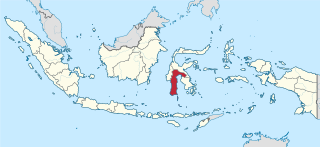
Palu, officially known as the City of Palu, is the capital and largest city of Central Sulawesi. Located on the northwestern coast of Sulawesi, the city borders Donggala Regency in the north and west, Parigi Moutong Regency in the east, and Sigi Regency in the south. The city's boundaries cover a land area of 395.06 square kilometers. According to the 2020 Indonesian census, the city has a population of 373,218, making it the third largest city on the island behind only Makassar and Manado. It is the finance, governance, and education center of the Central Sulawesi as well as one of several major cities in the entire island. The city hosts the province's main port and its biggest airport, as well as the location of majority of the province's public universities.

Palopo or Kota Palopo is a city located in South Sulawesi, Indonesia, and the second-largest city in the province. Until it acquired its autonomy, Palopo was the capital of Luwu Regency. The area of the city is 247.52 km2, and it had a population of 148,033 at the 2010 Census and 184,681 at the 2020 Census, comprising 92,444 males and 92,237 females.

North Padang Lawas is a regency in North Sumatra province of Indonesia. It has an area of 3,918.05 km2, and had a population of 223.049 at the 2010 Census and 260.720 at the 2020 Census. Its administrative seat is the town of Gunung Tua.

North Central Timor Regency is a regency in East Nusa Tenggara Province, Indonesia. It covers an area of 2,669.70 km2, and had a population of 229,803 at the 2010 Census and 259,829 at the 2020 Census. Its regency seat is located at the town of Kefamenanu, which had a population of 47,776 in 2020. The regency borders Timor Leste's Oecusse enclave, one of few Indonesian regions that have a land border with other countries.
Masamba is a small river town and district (kecamatan) in the North Luwu Regency of South Sulawesi Province of Indonesia which serves as the seat of the regency. The town lies on the Patikala River. It is served by Andi Jemma Airport. Much of the land in the region is swampy coastal plains with mangroves found in its shallow waters.

Luwu Regency is a regency of South Sulawesi Province, Indonesia. The administrative capital now lies at Belopa, since the former capital (Palopo) became an independent municipality (city) in 2006, at which date the then existing Luwu Regency was split into four entities - Palopo city, North Luwu Regency, East Luwu Regency, and the residual Luwu Regency. The regency now covers 2,909.08 km2 and had a population of 287,472 at the 2010 Census and 365,608 at the 2020 Census.
Andi Jemma Airport is an airport near Masamba, the capital city of North Luwu Regency in the province of South Sulawesi on the island of Sulawesi in Indonesia.
Seko Padang is an Austronesian language spoken in the North Luwu Regency of South Sulawesi, Indonesia. Together with Seko Tengah, Panasuan and Budong-Budong, it belongs to the Seko branch of the South Sulawesi subgroup.
Seko Tengah is an Austronesian language spoken in the North Luwu Regency of South Sulawesi, Indonesia. Together with Seko Padang, Panasuan and Budong-Budong, it belongs to the Seko branch of the South Sulawesi subgroup.

Aviastar Flight 7503 was a regional flight from Masamba to Makassar, Indonesia. On 2 October 2015, the de Havilland Canada DHC-6 Twin Otter aircraft serving the route went missing with 10 on board near Palopo minutes after takeoff. There was no distress call from the plane.
On 22 January 2019, floods caused by heavy rainfall struck the Indonesian province of South Sulawesi. At least 68 people were killed and thousands were displaced. Gowa Regency was particularly hard-hit, experiencing the majority of the fatalities.
In Indonesian law, the term "city" is generally defined as the second-level administrative subdivision of the Republic of Indonesia, an equivalent to regency. The difference between a city and a regency is that a city has non-agricultural economic activities and a dense urban population, while a regency comprises predominantly rural areas and is larger in area than a city. However, Indonesia historically had several classifications of cities.
The Seko Airport is an airport in Seko, North Luwu Regency, South Sulawesi, Indonesia.
Rampi Airport is an airport in Rampi, North Luwu Regency, South Sulawesi, Indonesia.

