Related Research Articles

Fort Lauderdale is a coastal city located in the U.S. state of Florida, 30 miles (48 km) north of Miami along the Atlantic Ocean. It is the county seat of and largest city in Broward County with a population of 182,760 as of the 2020 Census making it the tenth largest city in Florida. Along with Miami and Port St. Lucie, Fort Lauderdale is one of the three principal cities that comprise the Miami metropolitan area, which has a population of 6,166,488.

Lauderdale-by-the-Sea is a town in Broward County, Florida, United States, situated 33 miles north of Miami. As of the 2010 census, the population was 6,056. It is part of the Miami–Fort Lauderdale–West Palm Beach Metropolitan Statistical Area, which was home to 5,564,635 people at the 2010 census.
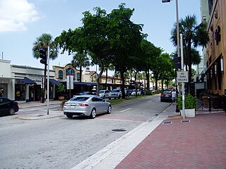
Las Olas Boulevard is a major east-west thoroughfare in Fort Lauderdale, Florida, United States that runs from SW 1st Avenue in the Central Business District to Florida State Road A1A in Fort Lauderdale Beach. The name "Las Olas" means "The Waves" in Spanish. The road once carried the designations of State Road A1A Alt. and State Road 842.
The Millionaires' Mile, Millionaire's Mile, Millionaires' Row, Millionaire's Row, Billionaires Row, Golden Mile or Alpha Street are the exclusive residential neighborhoods of various cities, often along one scenic strip such as a riverside or hilltop drive, or a wide city boulevard.

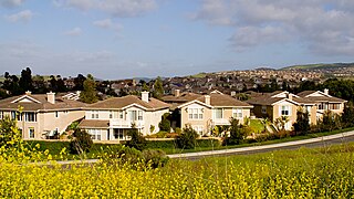
Hope Ranch is an unincorporated coastal suburb of Santa Barbara, California, located in Santa Barbara County. It is bounded on the east by Santa Barbara, on the north and west by the unincorporated area of Noleta, and on the south by the Pacific Ocean. As of the 2000 census, the area had an approximate population of 2,200. The ZIP codes are 93105 and 93110, and the community is in area code 805.

El Sereno is a Los Angeles neighborhood in the Eastside Los Angeles region of Los Angeles County, California.

The Industrial Canal is a 5.5 mile (9 km) waterway in New Orleans, Louisiana, United States. The waterway's proper name, as used by the U.S. Army Corps of Engineers and on NOAA nautical charts, is Inner Harbor Navigation Canal (IHNC). The more common "Industrial Canal" name is used locally, both by commercial mariners and by landside residents.
Westdale is a neighborhood in the Westside region of Los Angeles, California. It is represented by and has representatives on the Mar Vista Community Council.
The western border of Santa Monica, California, is the 3-mile (4.8 km) stretch of Santa Monica Bay. On its other sides, the city is bordered by various districts of Los Angeles: the northwestern border is Pacific Palisades, the eastern border is Brentwood north of Wilshire Boulevard and West Los Angeles south of Wilshire, the northeastern border is generally San Vicente Boulevard up to the Riviera Country Club, the southwestern border is Venice Beach and the southern border is with West Los Angeles and Mar Vista.

Beverly Park, divided into North Beverly Park and South Beverly Park, is a gated community in Los Angeles, California primarily known for its large houses and famous residents. It is between Mulholland Drive and Sunset Boulevard and Coldwater Canyon Drive and Beverly Glen Boulevard, east of the Beverly Glen neighborhood.
University Hills is a housing development on the campus of the University of California, Irvine (UCI) in southern Irvine, California, United States, consisting of 1226 for-sale homes and 384 rental units. University Hills was developed by the Irvine Campus Housing Authority, a not-for-profit corporation under the control of the university. UC Irvine developed the area as "a way to compensate for high Orange County housing costs that can keep a recruit from accepting a job at the university."
Poinsettia Heights is a neighborhood in the northeast section of Fort Lauderdale, Florida, and its boundaries are west of Federal Highway, north of Sunrise Boulevard and adjacent to the neighborhoods of Lake Ridge and Middle River Terrace. The original development, called "North Ridge," was built by Gill Construction Company right after World War II in the 1940s and early 1950s.
The Rio Vista neighborhood is a community of over 1,000 homes, situated next to downtown Fort Lauderdale, Florida. Its name means "River View" in Spanish. It is one of the oldest communities in Fort Lauderdale and features tree-lined streets, sidewalks and unique architecture.

Palisades del Rey was a 1921 neighborhood land development by Dickinson & Gillespie Co. that later came to be called the Playa del Rey district of Los Angeles County, California. It lay at an elevation of 135 feet. All of the houses in this area were custom built, many as beach homes owned by Hollywood actors and producers, including Cecil B. DeMille, Charles Bickford, and others.

Broadway–Flushing is a historic district and residential subsection of Flushing, Queens, New York City. The neighborhood comprises approximately 2,300 homes. It is located between 155th and 170th Streets to the west and east respectively, and is bounded on the north by Bayside and 29th Avenues, and on the south by Northern Boulevard and Crocheron Avenue. Broadway–Flushing is listed on the National Register of Historic Places.
Lakeshore/Lake Vista is a neighborhood of the city of New Orleans, Louisiana. A subdistrict of the Lakeview District Area, its boundaries as defined by the City Planning Commission are: Lake Pontchartrain to the north, Bayou St. John to the east, Allen Toussaint Boulevard to the south and Pontchartrain Boulevard and the New Basin Canal to the west. The neighborhood is composed of the Lakeshore and Lake Vista subdivisions, built on land reclaimed from Lake Pontchartrain. The Lakefront is a term sometimes used to name the larger neighborhood created by the Orleans Levee Board's land reclamation initiative in early 20th century New Orleans; it includes Lakeshore and Lake Vista, as well as Lakeshore Drive, the lakefront park system, the University of New Orleans, Lake Terrace, and Lake Oaks.

Victoria Park is a small neighborhood in the central region of Los Angeles, California. There are three Los Angeles Historic-Cultural Monuments located in Victoria Park.
Isle of Normandy or Normandy Island or Normandy Isles or Normandy Isle is a neighborhood of North Beach in the city of Miami Beach, Florida. It is located along the eastern shore of Biscayne Bay.

The Laguna Madre is a long, shallow, hypersaline lagoon along the western coast of the Gulf of Mexico in Nueces, Kenedy, Kleberg, Willacy and Cameron Counties in Texas, United States. It is one of seven major estuaries along the Gulf Coast of Texas. The roughly 20-mile (32 km) long Saltillo Flats land bridge divides it into Upper and Lower lagoons joined by the Intracoastal Waterway, which has been dredged through the lagoon. Cumulatively, Laguna Madre is approximately 130 miles (210 km) long, the length of Padre Island in the US. The main extensions include Baffin Bay in Upper Laguna Madre, Red Fish Bay just below the Saltillo Flats, and South Bay near the Mexican border. As a natural ecological unit, the Laguna Madre of the United States is the northern half of the ecosystem as a whole, which extends into Tamaulipas, Mexico approximately 144 miles (232 km) south of the US border, to the vicinity of the Rio Soto La Marina and the town of La Pesca, extending approximately 275 miles (443 km) through USA and Mexico in total.
References
- ↑ "The Council of Ft. Lauderdale Civic Associations, Inc.: Member Association Web Pages". www.cflca.org. Archived from the original (PDF) on 2007-11-01. Retrieved 2008-02-18.
- ↑ "Neighborhood Associations" (PDF). City of Fort Lauderdale. Archived from the original (PDF) on 2008-02-16. Retrieved 2008-02-18.