Effigy Mounds National Monument preserves more than 200 prehistoric mounds built by pre-Columbian Mound Builder cultures, mostly in the first millennium CE, during the later part of the Woodland period of pre-Columbian North America. Numerous effigy mounds are shaped like animals, including bears and birds.

Mille Lacs Kathio State Park, also known as Kathio Site, is a Minnesota state park on Mille Lacs Lake. The park preserves habitation sites and mound groups, believed to date between 3000 BC and 1750 AD, that document Dakota Indian culture and Ojibwe-Dakota relationships. The park contains 19 identified archaeological sites, making it one of the most significant archaeological collections in Minnesota. The earliest site dates to the Archaic period and shows evidence of copper tool manufacture. The Dakota lived in this area roughly until the 18th century, when many bands of them were moving southward into the prairies and river areas of southern Minnesota. At the same time, Ojibwe (Anishinaabe) were moving in from the east. Ojibwe oral tradition, published by William Whipple Warren, suggests that there was a battle in which they successfully took control of the area from the Lakota.
Big Mound City (8PB48) is a prehistoric site near Canal Point, Florida, United States. It is located 10 miles east of Canal Point, off U.S. Route 98. On May 24, 1973, it was added to the U.S. National Register of Historic Places. It is located inside the J.W. Corbett Wildlife Management Area.
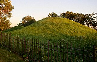
Indian Mounds Regional Park is a public park in Saint Paul, Minnesota, United States, featuring six burial mounds overlooking the Mississippi River. The oldest mounds were constructed about 2,500 years ago by local Indigenous people linked to the Archaic period, who may have been inspired by the burial style known as the Hopewell Tradition. Mdewakanton Dakota people are also known to have interred their dead here well into that period. At least 31 mounds were destroyed by development in the late 19th century. This burial mound group includes the tallest mounds constructed by people Indigenous to Minnesota and Wisconsin. Indian Mounds Regional Park is a component of the Mississippi National River and Recreation Area, a unit of the National Park System. In 2014, the extant Mounds Group was listed in the National Register of Historic Places. The nomination document describes the archaeology and context. A Cultural Landscape Study provides more context about the cultural landscape.

The Gideon H. Pond House is a historic house in Bloomington, Minnesota, United States. It is part of the Pond-Dakota Mission Park, which also includes the Oak Grove Mission site (1843–1852), a cemetery, and the remains of the Pond family farm and orchards. The site is significant within the history of the Minnesota River valley, the Dakota tribe, and Bloomington. The house is listed on the National Register of Historic Places.

The State Line Archeological District is a complex of archaeological sites and national historic district located west of Elizabethtown, Ohio, United States. Located on both sides of the Indiana/Ohio border, the historic district is composed of five contributing properties spread out across 8 acres (3.2 ha) of land. It is believed to have been the site of a village of the Fort Ancient culture of prehistoric Native Americans.

Shakopee is a city in and the county seat of Scott County, Minnesota, United States. It is southwest of Minneapolis. Sited on the south bank bend of the Minnesota River, Shakopee and nearby suburbs comprise the southwest portion of Minneapolis-Saint Paul, the nation's 16th-largest metropolitan area, with 3.7 million people. The population was 43,698 at the 2020 census.
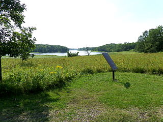
Inyan Ceyaka Otonwe, also called Little Rapids or simply Inyan Ceyaka, was a summer planting village of the Wahpeton Dakota on the Minnesota River in what is now Louisville Township, Minnesota, United States. Located near present-day city of Jordan, the village was occupied by the Wahpeton during the early nineteenth century, and likely before. Burial mounds indicate that possible ancestors of the Dakota lived at the site as early as 100 CE. The site was listed on the National Register of Historic Places in 1999 for having local significance in the theme of archaeology. The unmarked site is preserved within the Carver Rapids unit of the Minnesota Valley State Recreation Area.
American Indian Rock Art in Minnesota MPS is a Multiple Property Submission (MPS) of the eligibility of many rock art properties for listing on the National Register of Historic Places. The listing is to protect and preserve Native American petroglyphs, pictographs and petroform rock art sites in the present day U.S. state of Minnesota.

The Dunns Pond Mound is a historic Native American mound in northwestern Logan County, Ohio, United States. Located near Huntsville, it lies along the southeastern corner of Indian Lake in Washington Township. In 1974, the mound was listed on the National Register of Historic Places as a potential archeological site, with much of its significance deriving from its use as a burial site for as much as nine centuries.

This is a list of the National Register of Historic Places listings in Faribault County, Minnesota. This is intended to be a complete list of the properties and districts on the National Register of Historic Places in Faribault County, Minnesota, United States. The locations of National Register properties and districts for which the latitude and longitude coordinates are included below, may be seen in an online map.

The Book site is an archaeological site in Juniata County, Pennsylvania, United States. Consisting of the remnants of a burial mound and a prehistoric village, the site lies on both sides of Camp Resort Road in Beale Township, near the community of Beale.

Old Town is an archaeological site in Williamson County, Tennessee near Franklin. The site includes the remnants of a Native American village and mound complex of the Mississippian culture, and is listed on the National Register of Historic Places (NRHP) as Old Town Archaeological Site (40WM2).

The Hodgen's Cemetery Mound is a Native American mound in the far eastern part of the U.S. state of Ohio. Located in the village of Tiltonsville along the Ohio River shoreline of Jefferson County, the mound is a prehistoric earthwork and archaeological site, and it has been named a historic site.
Grand Mound is a prehistoric burial site in Koochiching County, Minnesota, United States. It is the largest surviving prehistoric structure in the upper Midwest, dating back to 200 BCE. The site was listed as a National Historic Landmark on June 23, 2011.
The Kay-Nah-Chi-Wah-Nung Historical Centre, or Manitou Mounds, is Canada's premier concentration of ancient burial mounds. Manitou Mounds National Historic Site, as it was once called, is a vast network of 30 village sites and 15 ancient burial mounds constructed from approximately 5000 BP during the Archaic Period, to 360 BP; it is one of the "most significant centres of early habitation and ceremonial burial in Canada." It is located on a river stretch known as Long Sault Rapids on the north side of Rainy River, approximately 54 kilometres east of Fort Frances, in the Rainy River District of Northwestern Ontario, Canada off highway 11. It was designated as a National Historic Site of Canada in 1969.
The Schilling Archeological District is a prehistoric Native American archaeological site on private property on Lower Grey Cloud Island in Cottage Grove, Minnesota, United States. It consists of a habitation site and mound group with artifacts that date from the Early Woodland Period to the Late Prehistoric Period. It was listed on the National Register of Historic Places in 1978 for having state-level significance in the theme of archaeology. It was nominated for its rare Early Woodland component, Middle Mississippian cultural influences, and potential to show climatic adaptations over time.

The Upper Hay Lake Archeological District is a prehistoric Native American archaeological site in Jenkins Township, Minnesota, United States. It consists of about 75 linear mounds—including one of the state's longest at 725 feet (221 m)—plus the sites of a village and a portage. The mound grouping has also been dubbed Fort Poualak. The site was listed on the National Register of Historic Places in 1978 for having local significance in the theme of archaeology. It was nominated for indicating an area of substantial activity during the Blackduck phase of the Late Woodland period.

The Fort Flatmouth Mounds form a prehistoric Native American archaeological site in Mission Township, Minnesota, United States. It consists of nine mounds grouped in a rough ellipse and a few additional mounds in close proximity. Early Euro-American settlers assumed the enclosure was built as a fort, hence the name, but it was more likely religious in nature. The site was listed on the National Register of Historic Places in 1973 for having state-level significance in the theme of archaeology. It was nominated for its information potential as a unique site in a region whose numerous mound and village sites indicate a long span of indigenous occupation.
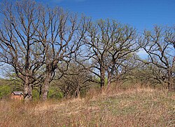
Morrison Mounds is a historic site north of Battle Lake, Minnesota, United States, consisting of 22 Native American burial mounds, built beginning around 800 B.C. Twenty are conical, one flat-topped and one elongated, all near Otter Tail Lake. The mound group has the oldest radiocarbon date of any in present-day Minnesota. Its construction is similar to others in the area, suggesting they were all built by members of the same tribe over a period of time. Similarities include a central burial pit, covered by logs, and a possibly crematory. It was listed on the National Register of Historic Places in 1973.