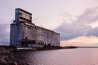
A grain elevator is a facility designed to stockpile or store grain. In the grain trade, the term "grain elevator" also describes a tower containing a bucket elevator or a pneumatic conveyor, which scoops up grain from a lower level and deposits it in a silo or other storage facility.

Sintaluta is a small town in Saskatchewan, Canada. The current population of Sintaluta is approximately 119 people according to the 2016 Canadian Census. The town is located about 85 km east of Regina. The town is located on the north side of the Trans-Canada Highway.

Beiseker is a village in the Canadian province of Alberta, approximately 70 kilometres (43 mi) northeast of Calgary. It is considered to be an outermost part of the Calgary Region, and is included within Calgary's Census Metropolitan Area (CMA). The village is surrounded by rural Rocky View County, and the closest neighbouring communities are Irricana, Kathyrn, and Acme.

Division No. 5 is a census division in Alberta, Canada. It is located in the north-central portion of southern Alberta and its largest urban community is the Town of Strathmore.

Champion is a village in southern Alberta, Canada within Vulcan County. It is located on Highway 23, approximately 74 kilometres (46 mi) north of Lethbridge and 147 kilometres (91 mi) south of Calgary.

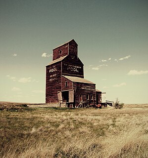
The Saskatchewan Wheat Pool was a grain handling, agri-food processing and marketing company based in Regina, Saskatchewan. The Pool created a network of marketing alliances in North America and internationally which made it the largest agricultural grain handling operation in the province of Saskatchewan. Before becoming Viterra, SWP had operated 276 retail outlets and more than 100 grain handling and marketing centres. The Saskatchewan Wheat Pool operated under the name of AgPro in the prairie provinces of Manitoba and Alberta. Begun as a co-operative in the 1920s, the company became a publicly traded corporation in the 1990s. After the 2007 takeover of its competitor, Winnipeg-based Agricore United, the Pool name was retired. The merged company operated under the name Viterra until 2013, when it was acquired by Glencore International.

Goodwater is a village in the Canadian province of Saskatchewan within the Rural Municipality of Lomond No. 37 and Census Division No. 2. The village is located approximately 50 km (31 mi) south of the City of Weyburn. Goodwater is located on Treaty 4 land, negotiated between the Cree, Saulteaux, and Assiniboine first peoples, and Alexander Morris, second Lieutenant Governor of Manitoba (1872–1877). Goodwater is currently part of the Souris - Moose Mountain federal riding.
Highway 33 is a highway in the southern portion of the Canadian province of Saskatchewan connecting Regina to Stoughton; the highway is divided near Regina. Highway 33 is about 139 km (86 mi) long.

Robsart is an unincorporated hamlet within the rural municipality of Reno No. 51, in the province of Saskatchewan, Canada. Robsart had a population of 20 at the 2016 Canada Census. Robsart previously incorporated an independent village since 1912 until it was dissolved into an unincorporated community on January 1, 2002 under the jurisdiction of the rural municipality of Reno No. 51. Robsart is located 48 km southwest of the town of Eastend at the junction of Highway 18 and Highway 13 approximately 170 km south-east of Medicine Hat, Alberta, 68 km south of the Town of Maple Creek.
Estuary is a hamlet in RM of Deer Forks No. 232 in the Canadian province of Saskatchewan. Nothing or very little remains of the former village of 800, but a private residence and a pioneer cemetery on a small hill known as Cemetery Hill, overlooking the South Saskatchewan River.

Vidora is an unincorporated community within the Rural Municipality of Reno No. 51, Saskatchewan, Canada. The community once had a population of 200 people in 1940 and has since declined to 1 resident. It previously held the status of a village until it was dissolved as an unincorporated community on January 1, 1952. The community is located between Robsart and Consul on highway 21 & highway 13 known as the Red Coat Trail. Very little remains of the former village, only one home that is also used as a post office still stands as of 2008. There are many cement foundations and sidewalks still found scattered around the town site, including the remnants of the old bank vault to the former Municipality Office that was moved to Consul.

Maybutt, also known as "New Stirling" or "New Town", is a former locality in the County of Warner No. 5, Alberta, Canada. The community is situated 1 km north of the Village of Stirling just off the CANAMEX Corridor between Lethbridge and the Canada–US border. The community has become a bedroom community to Lethbridge, with many newer acreages being developed in the area. The footprint of Maybutt is defined by its historic boundary roads, Young St., Sunnyside Ave., Front St. & Lorne Ave, and Etzikom Ave. York St., First Ave. and Second Ave. are the only interior streets left of the original street grid of Maybutt.

Retlaw is an unincorporated community located in the Municipal District of Taber, Alberta, Canada. The community once had a peak population of over 250 citizens and was even incorporated under the status of a village until it was dissolved into a hamlet under the jurisdiction of Improvement District No. 96 on March 1, 1939. Retlaw is located 2 km (1 mi) west of Highway 864 6 km (3 mi) west of Vauxhall and 42 km (26 mi) northwest of Taber and 75 km (46 mi) southwest of Brooks.

Neidpath, is a hamlet in Coulee Rural Municipality No. 136, Saskatchewan, Canada. The hamlet is located on Highway 363 and Highway 720 about 25 km east of the city of Swift Current.
Woolford is a hamlet in southern Alberta, Canada within Cardston County. It is located on Highway 503, approximately 16 kilometres (9.9 mi) southeast of Cardston between the St. Mary River and the Milk River Ridge. It is named after Thomas Woolford who came to the area in 1900.

Raley, Alberta is an unincorporated community in Cardston County, Alberta, Canada. The population of Raley was 5 in 1966. The community is located about 4 km north of Highway 3, and about 15 km east of the Town of Cardston. Raley is named after C. Raley, of Lethbridge.
Bents is an unincorporated community in Marriott No. 317, Saskatchewan, Canada. Prior to the town being founded the area was referred to as Piche. Bents took its name from Longniddry Bents in Scotland. Its derelict wooden grain elevator was once the subject of a National Geographic photograph. The remnants of the town are now located on private property.
Ruthilda is a former village in the Rural Municipality of Grandview No. 349, Saskatchewan, Canada. It dissolved from village status to become part of the Rural Municipality of Grandview No. 349 on December 31, 2013. Ruthilda is located about 5 km south of Highway 51 approximately 30 km southwest of the Town of Biggar.

Wartime is an unincorporated community and former hamlet, within the Rural Municipality of Monet No. 257, Saskatchewan, Canada. The community is located along Highway 44 approximately 13 km west of Elrose along Canadian National Railway's Elrose sub-division track. The community once boasted a train station built in 1914 which was demolished in 1978, two grain elevators; a Saskatchewan Wheat Pool and a Federal elevator as well as a wooden water tank. The elevators have disappeared but the water tower is still standing and in use.

Horizon, located on the south side of Channel Lake, is a hamlet in Bengough Rural Municipality No. 40, Saskatchewan, Canada. It previously held the status of a village until December 31, 1973. The hamlet is located 60 km (37 mi) east of the Town of Assiniboia on highway 13.
