
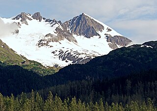
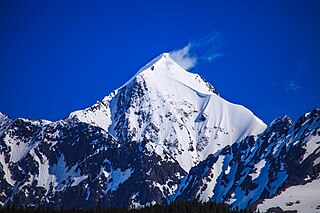
Mount Huxley is a 12,216-foot glaciated mountain summit located in the Saint Elias Mountains of Wrangell-St. Elias National Park and Preserve, in the U.S. state of Alaska. The remote peak is situated 75 mi (121 km) northwest of Yakutat, and 8.7 mi (14 km) west-northwest of Mount Saint Elias. The peak rises above the Columbus Glacier and Bagley Icefield to its north, the Tyndall Glacier to the south, and the Yahtse Glacier to the west. Precipitation runoff from the mountain drains into the Gulf of Alaska. The mountain was named in 1886 by English mountaineer Harold Ward Topham for Thomas Henry Huxley (1825-1895), an English biologist. The mountain was officially named Huxley Peak in 1917, but the name was officially changed to Mount Huxley in 1968 by the U.S. Board on Geographic Names. The first ascent of the peak was made June 9, 1996 by Paul Claus who landed his plane at 11,500 feet elevation on the western flank and climbed the remaining distance to the summit. The second ascent of Mt. Huxley, and first complete ascent from base to summit, was made in June 2018 by Scott Peters, Andrew Peter, and Ben Iwrey starting from the Columbus Glacier.

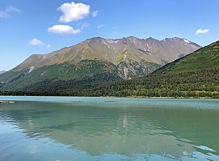
Maynard Mountain is a 4,137-foot (1,261 m) mountain summit located in the Chugach Mountains, in the U.S. state of Alaska. The peak is situated in Chugach National Forest, 3 mi (5 km) northwest of Whittier, Alaska, at the isthmus of the Kenai Peninsula, where the Chugach Mountains meet the Kenai Mountains. Nearby peaks include Bard Peak, 4.14 mi (7 km) to the south, and Begich Peak, 3.1 mi (5 km) to the west-northwest. Although modest in elevation, relief is significant since the eastern aspect of the mountain rises up from the tidewater of Prince William Sound's Passage Canal in approximately one mile. Maynard Mountain is often seen and photographed in the background behind Portage Lake, a popular tourist and recreation destination. The Anton Anderson Memorial Tunnel, often called the Whittier Tunnel, is a dual-use highway and railroad tunnel that passes through Maynard Mountain. With a length of 13,300 feet, it is the second-longest highway tunnel and longest combined rail and highway tunnel in North America.
Phoenix Peak is a 5,187-foot (1,581 m) mountain summit located in the Kenai Mountains, on the Kenai Peninsula, in the U.S. state of Alaska. The peak is situated in Kenai Fjords National Park, 2 mi (3 km) southwest of Mount Benson, 1.1 mi (2 km) northwest of Marathon Mountain, and 3.5 mi (6 km) west of Seward, Alaska. Precipitation runoff from the mountain and meltwater from its glaciers drains into tributaries of the Resurrection River. The first ascent of the peak was made July 23, 1964, by Don Stockard of the Mountaineering Club of Alaska. The peak was named in 1965 by the Mountaineering Club of Alaska for the first ship ever built in Russian America, the Phoenix, which was constructed in 1794 by Russians in nearby Resurrection Bay. The mountain's toponym was officially adopted in 1966 by the United States Geological Survey.
Andy Simons Mountain is a prominent 6,407-foot (1,953 m) double summit mountain located in the Kenai Mountains, and the fourth-highest peak on the Kenai Peninsula in the state of Alaska. The true summit is 1.3 mile west of the 5,300+ foot subsidiary east peak on this five-mile-long northwest-to-southeast trending mountain. The mountain is situated in Chugach National Forest, 7.2 mi (12 km) east of Mount Adair, and 17 mi (27 km) north of Seward, Alaska. The Seward Highway and Alaska Railroad traverse its western foot. Precipitation runoff from the mountain drains into Kenai Lake.

Passage Peak is a prominent 5,990-foot (1,826 m) mountain summit located in the Chugach Mountains, in the U.S. state of Alaska. The unofficially named peak is situated in Chugach National Forest, 9 mi (14 km) northeast of Whittier, Alaska, near the isthmus of the Kenai Peninsula, where the Chugach Mountains meet the Kenai Mountains. Nearby peaks include Maynard Mountain and Boggs Peak, each approximately 10 mi (16 km) to the southwest. Although modest in elevation, relief is significant since the southern aspect of the mountain rises up from the tidewater of Prince William Sound's Passage Canal in approximately five miles. The peak takes its name from Passage Canal, which in turn was named in 1794 by Captain George Vancouver, presumably because it leads to a portage connecting Prince William Sound with Cook Inlet.

Mount Madson, also known as Madson Mountain, is a prominent 5,266-foot (1,605 m) summit in the U.S. state of Alaska.
Santa Ana Peak is a 4,764-foot-elevation (1,452-meter) mountain summit in Alaska, United States.

Mount Mary is a 4,820-foot-elevation (1,469-meter) mountain summit in Alaska, United States.

Mount Eva is a 5,019-foot-elevation (1,530-meter) mountain summit in Alaska, United States.

Tiehacker Mountain is a 4,435-foot-elevation (1,352-meter) mountain summit in Alaska, United States.

Mount Gerdine is an 11,258-foot-elevation (3,431-meter) mountain summit in Alaska.
The Rowel is a 9,806-foot-elevation (2,989-meter) mountain summit in Alaska.

Mount Chichantna is a 10,893-foot-elevation (3,320-meter) mountain summit in Alaska.
Hearth Mountain is a 6,182-foot-elevation (1,884-meter) mountain summit in Alaska, United States.

Paradise Peak is a 6,050-foot-elevation (1,844-meter) mountain summit in Alaska, United States.

Haydon Peak is an 11,924-foot-elevation (3,634-meter) mountain summit in Alaska, United States.
Mount Ogilvie is a 7,867-foot-elevation (2,398-meter) mountain summit located on, and in part defining, the international border between Alaska, United States, and British Columbia, Canada.

Rainbow Mountain is a 6,841-foot-elevation (2,085-meter) summit in Alaska, United States.

Shakespeare Shoulder is a 3,517-foot (1,072 m) mountain summit located in the Kenai Mountains in the U.S. state of Alaska. The peak is situated 1.6 miles (2.6 km) southwest of Whittier, Alaska, in Chugach National Forest, at the isthmus of the Kenai Peninsula where the Kenai Mountains meet the Chugach Mountains. Although modest in elevation, topographic relief is significant since the summit rises from sea-level of Passage Canal in 1.6 miles (2.6 km). Shakespeare Shoulder is often seen and photographed with Bard Peak because they are in the background behind Portage Lake, a popular tourist and recreation destination. The mountain's toponym was officially adopted in 1977 by the United States Board on Geographic Names. The peak's name refers to William Shakespeare, known as The Bard of Avon.

Mount McGhan is a 4,730-foot-elevation (1,442-meter) mountain summit in Alaska, United States.

