
The Andaman and Nicobar Islands is a union territory of India comprising 836 islands, of which only 31 are inhabited. These islands are grouped into two main clusters: the northern Andaman Islands and the southern Nicobar Islands, separated by a 150 km (93 mi) wide channel. The capital and largest city of the territory, Port Blair, is located approximately 1,190 km (740 mi) from Chennai and 1,255 km (780 mi) from Kolkata in mainland India. The islands are situated between the Bay of Bengal to the west and the Andaman Sea to the east. The northernmost point is 901 km (560 mi) from the mouth of the Hooghly River. Indira Point, located at 6°45’10″N and 93°49’36″E on the southern tip of Great Nicobar, is the southernmost point of India.
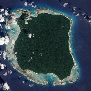
North Sentinel Island is one of the Andaman Islands, an Indian archipelago in the Bay of Bengal which also includes South Sentinel Island. The island is a protected area of India. It is home to the Sentinelese, an indigenous tribe in voluntary isolation who have defended, often by force, their protected isolation from the outside world. The island is about 8 kilometres (5.0 mi) long and 7 kilometres (4.3 mi) wide, and its area is approximately 60 square kilometres (23 sq mi).

North Andaman Island is the northern island of Great Andaman of the Andaman Islands. It belongs to the North and Middle Andaman administrative district, part of the Indian union territory of Andaman and Nicobar Islands. the island is lying 137 km (85 mi) north from Port Blair.
Rutland Island is an island of the Andaman Islands. It belongs to the South Andaman administrative district, part of the Indian union territory of Andaman and Nicobar Islands. The island is located 20 km (12 mi) south from Port Blair.
Indira Point, the southernmost point of India's territory, is a village in the Nicobar district at Great Nicobar Island of Andaman and Nicobar Islands in India. It is located in the Great Nicobar tehsil.
Interview Island is an island of the Andaman Islands. It belongs to the North and Middle Andaman administrative district, part of the Indian union territory of Andaman and Nicobar Islands. It lies 125 km (78 mi) north of Port Blair.
Strait Island is an island of the Andaman Islands. It belongs to the North and Middle Andaman administrative district, part of the Indian union territory of Andaman and Nicobar Islands. The island lies 63 km (39 mi) north from Port Blair.
North and Middle Andaman district is one of the 3 districts of the Indian Union Territory of Andaman and Nicobar Islands located in the Bay of Bengal. Mayabunder town is the district headquarters. The area covered by this district is 3251.85 km2.
Ramnagar is a village in the southeastern part of North Andaman Island. It belongs to the Diglipur county, Andaman and Nicobar territory of India. It has a population of about 1400 people.
Landfall Island is the northernmost island of the Indian union territory of Andaman and Nicobar Islands. It belongs to the territory's North and Middle Andaman administrative district. The island lies 220 km (137 mi) north of Port Blair, and is situated 300 km (186 mi) south of Myanmar. It is home to the Kari tribe.
INS Kohassa is an Indian naval air station under the Andaman and Nicobar Command of the Indian Armed Forces. It is located at Shibpur, a village located on North Andaman Island.
Pulomilo is an island in the Nicobar district of Andaman and Nicobar Islands, India, and is home to a village of the same name. It is located just north of Little Nicobar Island.
East Island is an island of the Andaman Islands. It belongs to the North and Middle Andaman administrative district, part of the Indian union territory of Andaman and Nicobar Islands. The island is located 220 km (137 mi) north from Port Blair.
Smith Island is an island of the Andaman Islands. It belongs to the North and Middle Andaman administrative district, part of the Indian union territory of Andaman and Nicobar Islands. The island lies 298 km (185 mi) north of Port Blair.
Curlew Island is an island of the Andaman Islands. It belongs to the North and Middle Andaman administrative district, part of the Indian union territory of Andaman and Nicobar Islands. The island lies 150 km (93 mi) north of Port Blair.
Stewart Island is an island of the Andaman Islands. It belongs to the North and Middle Andaman administrative district, part of the Indian union territory of Andaman and Nicobar Islands. The island lies 150 km (93 mi) north of Port Blair. Its population only consists of two people.
Aves Island is an island of the Andaman Islands. It belongs to the North and Middle Andaman administrative district, part of the Indian union territory of Andaman and Nicobar Islands. The island lies 140 km (87 mi) north from Port Blair.
Long Island is an island of the Andaman Islands. It belongs to the North and Middle Andaman administrative district, part of the Indian union territory of Andaman and Nicobar Islands. The island is located 80 km (50 mi) north from Port Blair.
North Passage Island is an island of the Andaman Islands. It belongs to the North and Middle Andaman administrative district, part of the Indian union territory of Andaman and Nicobar Islands. The island lies 80 km (50 mi) north from Port Blair.
Khudirampur is a village in Diglipur, North Andaman Islands.

