Kataysk is a town and the administrative center of Kataysky District in Kurgan Oblast, Russia, located on the Iset River 214 kilometers (133 mi) northwest of Kurgan, the administrative center of the oblast. Population: 14,003 (2010 Census); 15,836 (2002 Census); 16,789 (1989 Soviet census).
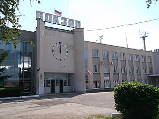
Shumikha is a town and the administrative center of Shumikhinsky District in Kurgan Oblast, Russia, located 133 kilometers (83 mi) west of Kurgan, the administrative center of the oblast. Population: 17,819 (2010 Census); 19,083 (2002 Census); 21,984 (1989 Soviet census).
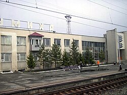
Makushino is a town and the administrative center of Makushinsky District in Kurgan Oblast, Russia, located 181 kilometers (112 mi) east of Kurgan, the administrative center of the oblast. Population: 8,338 (2010 Census); 9,942 (2002 Census); 10,535 (1989 Soviet census).

Polovinsky District is an administrative and municipal district (raion), one of the twenty-four in Kurgan Oblast, Russia. It is located in the south of the oblast. The area of the district is 2,728 square kilometers (1,053 sq mi). Its administrative center is the rural locality (a selo of Polovinnoye. Population: 12,255 ; 16,295 ; 17,123 . The population of Polovinnoye accounts for 37.9% of the district's total population.

Almenevsky District is an administrative and municipal district (raion), one of the twenty-four in Kurgan Oblast, Russia. It is located in the southwest of the oblast. The area of the district is 2,510 square kilometers (970 sq mi). Its administrative center is the rural locality of Almenevo. Population: 12,412 (2010 Census); 15,240 ; 18,983 (1989 Soviet census). The population of Almenevo accounts for 34.7% of the district's total population.

Chastoozersky District is an administrative and municipal district (raion), one of the twenty-four in Kurgan Oblast, Russia. It is located in the east of the oblast. The area of the district is 1,926 square kilometers (744 sq mi). Its administrative center is the rural locality of Chastoozerye. Population: 5,924 (2010 Census); 7,762 ; 9,178 (1989 Soviet census). The population of Chastoozerye accounts for 46.4% of the district's total population.

Dalmatovsky District is an administrative and municipal district (raion), one of the twenty-four in Kurgan Oblast, Russia. It is located in the northwest of the oblast. The area of the district is 3,530 square kilometers (1,360 sq mi). Its administrative center is the town of Dalmatovo. Population: 29,476 (2010 Census); 35,176 ; 39,785 (1989 Soviet census). The population of Dalmatovo accounts for 47.2% of the district's total population.

Kargapolsky District is an administrative and municipal district (raion), one of the twenty-four in Kurgan Oblast, Russia. It is located in the center of the oblast. The area of the district is 3,220 square kilometers (1,240 sq mi). Its administrative center is the urban locality of Kargapolye. Population: 31,832 (2010 Census); 34,854 ; 38,518 (1989 Soviet census). The population of Kargapolye accounts for 26.5% of the district's total population.
Kataysky District is an administrative and municipal district (raion), one of the twenty-four in Kurgan Oblast, Russia. It is located in the northwest of the oblast. The area of the district is 2,670 square kilometers (1,030 sq mi). Its administrative center is the town of Kataysk. Population: 23,991 (2010 Census); 28,099 ; 31,720 (1989 Soviet census). The population of Kataysk accounts for 58.4% of the district's total population.

Mokrousovsky District is an administrative and municipal district (raion), one of the twenty-four in Kurgan Oblast, Russia. It is located in the northeast of the oblast. The area of the district is 3,080 square kilometers (1,190 sq mi). Its administrative center is the rural locality of Mokrousovo. Population: 13,115 (2010 Census); 15,379 ; 17,157 (1989 Soviet census). The population of Mokrousovo accounts for 37.0% of the district's total population.
Pritobolny District is an administrative and municipal district (raion), one of the twenty-four in Kurgan Oblast, Russia. It is located in the south of the oblast. The area of the district is 2,302 square kilometers (889 sq mi). Its administrative center is the rural locality of Glyadyanskoye. Population: 14,592 (2010 Census); 17,596 ; 26,638 (1989 Soviet census). The population of Glyadyanskoye accounts for 27.2% of the district's total population.

Safakulevsky District is an administrative and municipal district (raion), one of the twenty-four in Kurgan Oblast, Russia. It is located in the southwest of the oblast. The area of the district is 2,280 square kilometers (880 sq mi). Its administrative center is the rural locality of Safakulevo. Population: 13,120 (2010 Census); 16,957 ; 19,627 (1989 Soviet census). The population of Safakulevo accounts for 27.7% of the district's total population.
Shatrovsky District is an administrative and municipal district (raion), one of the twenty-four in Kurgan Oblast, Russia. It is located in the north of the oblast. The area of the district is 3,580 square kilometers (1,380 sq mi). Its administrative center is the rural locality of Shatrovo. Population: 18,446 (2010 Census); 23,009 ; 28,435 (1989 Soviet census). The population of Shatrovo accounts for 30.8% of the district's total population.

Shchuchansky District is an administrative and municipal district (raion), one of the twenty-four in Kurgan Oblast, Russia. It is located in the west of the oblast. The area of the district is 2,809 square kilometers (1,085 sq mi). Its administrative center is the town of Shchuchye. Population: 23,547 (2010 Census); 26,392 ; 30,743 (1989 Soviet census). The population of Shchuchye accounts for 46.6% of the district's total population.

Chastoozerye is a rural locality and the administrative center of Chastoozersky District, Kurgan Oblast, Russia. Population: 2,749 (2010 Census); 2,843 (2002 Census); 3,013 (1989 Soviet census).
Glyadyanskoye is a rural locality and the administrative center of Pritobolny District, Kurgan Oblast, Russia. Population: 3,964 (2010 Census); 4,335 (2002 Census); 4,993 (1989 Soviet census).
Zverinogolovskoye is a rural locality and the administrative center of Zverinogolovsky District, Kurgan Oblast, Russia. Population: 4,060 (2010 Census); 4,502 (2002 Census);
Ketovo is a rural locality and the administrative center of Ketovsky District, Kurgan Oblast, Russia. Population: 7,251 (2010 Census); 7,127 (2002 Census); 6,377 (1989 Soviet census).
Mokrousovo is a rural locality and the administrative center of Mokrousovsky District, Kurgan Oblast, Russia. Population: 4,849 (2010 Census); 4,963 (2002 Census); 5,105 (1989 Soviet census).
Shatrovo is a rural locality and the administrative center of Shatrovsky District, Kurgan Oblast, Russia. Population: 5,688 (2010 Census); 6,441 (2002 Census); 7,308 (1989 Soviet census).