
The Bernese Alps are a mountain range of the Alps, located in western Switzerland. Although the name suggests that they are located in the Berner Oberland region of the canton of Bern, portions of the Bernese Alps are in the adjacent cantons of Valais, Fribourg and Vaud, the latter being usually named Fribourg Alps and Vaud Alps respectively. The highest mountain in the range, the Finsteraarhorn, is also the highest point in the canton of Bern.

The Diablerets are a huge ice-covered mountain massif of the Alps, culminating at the Sommet des Diablerets at 3,210 metres (10,530 ft) above sea level and straddling the border between the Swiss cantons of Vaud (VD) and Valais (VS). The northeastern part of the massif stretches also into the canton of Bern (BE).

The Rhône Glacier is a glacier in the Swiss Alps and the source of the river Rhône and one of the primary contributors to Lake Geneva in the far eastern end of the Swiss canton of Valais. Because the glacier is located close to the Furka Pass road it is easily accessible.

The Grimsel Pass is a mountain pass in Switzerland, crossing the Bernese Alps at an elevation of 2,164 metres (7,100 ft). The pass connects the Haslital, the upper valley of the river Aare, with the upper valley of the Rhône. In so doing, and as the Aare is a tributary of the Rhine, the pass crosses the continental divide between the North Sea and the Mediterranean Sea.

The Alps cover a large area. This article describes the delimitation of the Alps as a whole and of subdivisions of the range, follows the course of the main chain of the Alps and discusses the lakes and glaciers found in the region.

Oberwald is a village in the municipality of Obergoms in Goms District in the canton of Valais in Switzerland.

Guttannen is a municipality in the Interlaken-Oberhasli administrative district in the canton of Bern in Switzerland.

The Wildstrubel is a mountain of the Alps, straddling the border between the Swiss cantons of Bern and Valais. It forms a large glaciated massif, about 15 km wide, extending between the Rawil Pass and the Gemmi Pass. Along with the Muverans, the Diablerets and the Wildhorn, the Wildstrubel is one of the four distinct mountain massifs of the Bernese Alps that lie west of the Gemmi Pass. The massif of the Wildstrubel is at the centre between the valleys of Simmental (BE), Engstligental (BE) and the Rhone (VS), the exact location of the tripoint being the summit of the Schneehorn. It comprises several distinct summits, including the Wetzsteinhorn, the Rohrbachstein, the Weisshorn, the Pointe de la Plaine Morte, Mont Bonvin, the Trubelstock and the Schneehorn. The main crest with the almost equally high summits of the Mittelgipfel and the Grossstrubel forms an amphitheatre oriented eastward which ends at the Steghorn and the Daubenhorn. This area encloses the Wildstrubel Glacier. To the southwest, the Wildstrubel overlooks the high plateau of the Plaine Morte Glacier, which also includes an unnamed lake below the Schneehorn.

The Dammastock is the highest mountain in the Urner Alps in Switzerland and is part of the Winterberg massif. Its summit ridge forms the border between the cantons of Uri and the Valais. It is the highest summit in the canton of Uri. The tripoint between the cantons of Berne, Valais and Uri lies near the Eggstock, north of the Dammastock. Politically, the Dammastcok is split between the municipalities of Göschenen (Uri) and Obergoms (Valais).
The Uri Alps are a mountain range in Central Switzerland and part of the Western Alps. They extend into the cantons of Obwalden, Valais, Bern, Uri and Nidwalden and are bordered by the Bernese Alps and the Emmental Alps to the west, the Schwyzer Alps to the north, the Lepontine Alps to the south and the Glarus Alps to the east (Reuss).

The Wildhorn is a mountain of the Alps, straddling the border between the Swiss cantons of Bern and Valais. At 3,248 metres (10,656 ft) above sea level, it is the highest summit of the Bernese Alps west of the Gemmi Pass. It forms a large glaciated massif, about 10 km wide, extending between the Sanetsch Pass and the Rawil Pass. Along with the Muverans, the Diablerets and the Wildstrubel, the Wildhorn is one of the four distinct mountain massifs of the Bernese Alps that lie west of the Gemmi Pass. The massif of the Wildhorn is at the centre between the valleys of the Saane, Simme and the Rhone (Valais). It comprises several distinct summits, including the Arpelistock, Le Sérac, the Geltenhorn, the Sex Noir, the Sex Rouge, the Schnidehorn and the Six des Eaux Froides. The main crest is between the glaciers named Tungelgletscher and Glacier du Wildhorn. South of the main summit is the almost equally high summit of Mont Pucel. The Wildhorn is surrounded by several large mountain lakes: the Lac de Sénin, the Lauenensee, the Iffigsee, the Lac de Tseuzier and the Lac des Audannes. The Tungelgletscher, on the north-east face, was measured as 1.9 km in length in 1973.

The Witenwasserenstock is a peak between the Swiss cantons of Valais and Uri, located in the Lepontine Alps. Close to the summit lies the tripoint border between the cantons of Valais, Uri and Ticino and the triple watershed of the Rhine, Po and Rhône basins.

The Fiescher Glacier is a valley glacier on the south side of the Bernese Alps in the canton of Valais, Switzerland. 16 km (9.9 mi) in length, it is the second longest glacier in the Alps. The glacier covers an area of 33 km2 (13 sq mi).

Pizzo Rotondo is a mountain in the Lepontine Alps. At 3,190 metres above sea level, it is the highest mountain lying on the border between the cantons of Ticino and Valais, as well as the highest summit of the Lepontine Alps lying between Nufenen Pass and Lukmanier Pass.
The Scheuchzerhorn is a mountain of the Bernese Alps, located west of the Grimsel Pass in the canton of Bern. It lies north-east of the Oberaarhorn, on the range separating the valley of the Unteraar Glacier from the valley of the Oberaar Glacier.

The Agassizhorn is a mountain of the Bernese Alps in Switzerland. It lies just north-west of the Finsteraarhorn, the main summit of the range. The Agassizhorn is the tripoint between the valleys of the Lower Grindelwald Glacier, the Unteraar Glacier and the Fiescher Glacier. Because the Lower Grindelwald and Unteraar glaciers drain into the Aar and hence the Rhine and North Sea, whilst the Fiescher glacier drains into the Rhone and hence the Mediterranean Sea, the Sidelhorn lies on the European continental divide.
Obergoms is the upper part of the Goms and a municipality in the district of Goms in the canton of Valais in Switzerland. It was formed on 1 January 2009 when the three municipalities Ulrichen, Obergesteln and Oberwald merged.

The Gärstenhörner is a mountain in the Urner Alps, located on the border between the Swiss cantons of Bern and Valais. It lies on the range west of the Rhone Glacier, and east of the Grimsel Pass. The Gärstenhörner has three summits: the Mittler Gärstenhorn, the Hinter Gärstenhorn and the Vorder Gärstenhorn.

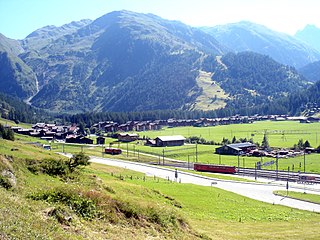
Gletsch is a hamlet in the German-speaking half of the canton of Valais, located in the upper Rhone valley, called Obergoms, 2.5 kilometres (1.6 mi), southeast below the Rhone Glacier's mouth and itself the headwaters of the Rhône. It is called Gletsch, since the first building was the predecessor of the Hôtel Glacier du Rhône built more or less just next to the glacier's mouth in 1830.
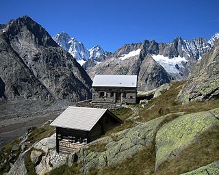
The Lauteraar Hut is a mountain hut of the Swiss Alpine Club, located south-west of Handegg in the canton of Bern. The hut lies at a height of 2,392 metres (7,848 ft) above sea level, above the Unteraar Glacier, at the foot of the Hienderstock in the Bernese Alps.

