Eswatini, formally the Kingdom of Eswatini and also known by its former official name Swaziland and formerly the Kingdom of Swaziland, is a landlocked country in Southern Africa. It is bordered by Mozambique to its northeast and South Africa to its north, west, south, and southeast. At no more than 200 km (120 mi) north to south and 130 km (81 mi) east to west, Eswatini is one of the smallest countries in Africa; despite this, its climate and topography are diverse, ranging from a cool and mountainous highveld to a hot and dry lowveld.

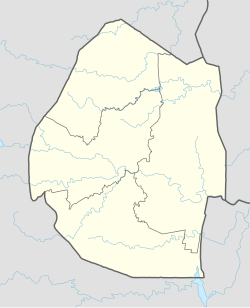
Eswatini, is a country in Southern Africa lying between Mozambique and South Africa. The country is located at the geographic coordinates 26°30′S31°30′E. Eswatini has an area of 17,363 square kilometres, of which 160 are water. The major regions of the country are Lowveld, Midveld and Highveld.
The economy of Eswatini is fairly diversified. Agriculture, forestry and mining account for about 13 percent of Eswatini's GDP whereas manufacturing represent 37 percent of GDP. Services – with government services in the lead – constitute the other 50 percent of GDP.

Mbabane is the most populous city in Eswatini, and is one of the two capitals, serving as the executive capital.

South Africa occupies the southern tip of Africa, its coastline stretching more than 2,850 kilometres from the desert border with Namibia on the Atlantic (western) coast southwards around the tip of Africa and then northeast to the border with Mozambique on the Indian (eastern) coast. The low-lying coastal zone is narrow for much of that distance, soon giving way to a mountainous escarpment that separates the coast from the high inland plateau. In some places, notably the province of KwaZulu-Natal in the east, a greater distance separates the coast from the escarpment. Although much of the country is classified as semi-arid, it has considerable variation in climate as well as topography. The total land area is 1,220,813 km2 (471,359 sq mi). It has the 23rd largest Exclusive Economic Zone of 1,535,538 km2 (592,875 sq mi).

KwaZulu-Natal is a province of South Africa that was created in 1994 when the government merged the Zulu bantustan of KwaZulu and Natal Province.

Mutare, formerly known as Umtali until 1982, is the capital and largest city in the province of Manicaland. It is the third most populated in Zimbabwe. Having surpassed Gweru in the 2012 census, with an urban population of 224,802 and approximately 260,567 in the surrounding districts, Mutare adds to the wider metropolitan area a total population of over 500,000 people. Mutare is also the capital of Manicaland Province and the largest city in eastern Zimbabwe.
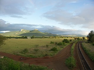
The Lebombo Mountains, also called Lubombo Mountains, are an 800 km-long (500 mi), narrow range of mountains in Southern Africa. They stretch from Hluhluwe in KwaZulu-Natal in the south to Punda Maria in the Limpopo Province in South Africa in the north. Parts of the mountain range are also found in Mozambique and Eswatini.

Mbombela, formerly Nelspruit, is a city in northeastern South Africa. It is the capital of the Mpumalanga province. Located on the Crocodile River, the city lies about 110 km (68 mi) by road west of the Mozambique border, 330 km (210 mi) east of Johannesburg and 82 km (51 mi) north of the Eswatini border. Mbombela was one of the host cities of the 2010 FIFA World Cup.

Saint Thomas, once known as Saint Thomas in the East, is a suburban parish situated at the south eastern end of Jamaica, within the county of Surrey. It is the birthplace of Paul Bogle, designated in 1969 as one of Jamaica's seven National Heroes. Morant Bay, its chief town and capital, is the site of the Morant Bay Rebellion in 1865, of which Bogle was a leader.
Mkuze, also named Mkhuze or uMkhuze is a small town in Northern KwaZulu-Natal, South Africa. It is located approximately 350 km from the city of Durban. It is along the N2 road en route to Johannesburg, Eswatini and Mozambique; between the Mkuze River and Intaba Yemikhovu. Mkuze is some distance from other small towns such as Hluhluwe (50 km), Nongoma (76 km), Pongola (65 km), and Jozini (25 km). Mkuze is the seat of Umkhanyakude District Municipality.

The Komati River, also known as the Inkomati River or Incomati River, is a river in South Africa, Eswatini and Mozambique. Originating in north-western Eswatini, it is joined by the Crocodile River in the Lebombo Mountains, enters far south-western Mozambique below the border town of Komatipoort, and enters the Indian Ocean around 24 km (15 mi) north-east of Maputo.

Lobamba is a city in Eswatini, and is one of the two capitals, serving as the legislative, traditional, spiritual, seat of government of the Parliament of Eswatini, and Ludzidzini Royal Village, the residence of Queen Ntfombi, the Queen Mother.
Siteki is a town in eastern Eswatini, lying west of the Lebombo Mountains, with an estimated population of 6,381 as of 2013. It is named for a declaration of Mbandzeni permitting his troops to marry. The town name was listed as Stegi in the 1966 census, and the population then was 1,457. The 1956 census counted 612 residents in Stegi.
Mhlumeni is a town in eastern Eswatini on the border with Mozambique. It lies in the Lubombo Mountains about 40 kilometres north-east of Siteki in Lubombo District.
Railway stations in Mozambique include:
Education in Eswatini includes pre-school, primary, secondary and high schools, for general education and training (GET), and universities and colleges at tertiary level.
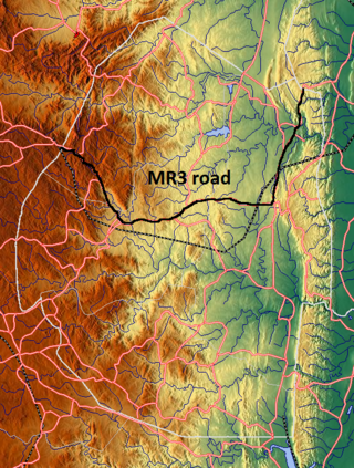
The MR3 road, also known as the Matsapha–Mbabane–Ngwenya road or Road No. MR3, is a major highway of Eswatini. It is one of the busiest roads in the country, crossing it from east to west. Along with the MR7 and MR8 roads, it forms the "backbone of Swaziland's internal transport system." It connects the EN5 road in Mozambique near Namaacha at 25°59′21″S31°59′53″E to the N17 road in South Africa at 26°12′45″S30°59′18″E, near Ngwenya. The road passes through Hlane Royal National Park and through the capital of Mbabane, about 110 kilometres (68 mi) further to the southwest. The highway descends into the Ezulwini Valley in four lanes. At Manzini, a bridge crosses the Mzimene River.

The border between Mozambique and South Africa is divided into two segments, separated by the kingdom of Eswatini. The northern segment, which is 410 kilometres (255 mi) long, runs north–south along the Lebombo Mountains from Zimbabwe to Eswatini. The southern segment, which is 81 kilometres (50 mi) long, runs east–west across Maputaland from Eswatini to the Indian Ocean.

Lubombo is a region of Eswatini, located in the east of the country. It has an area of 5,849.11 km2 and a population of 212,531 (2017). Its administrative center is Siteki. It borders all three other regions: Hhohho to the north, Manzini to the west, and Shiselweni to the south. It is divided into 11 tinkhundla.