Skipwith, Virginia | |
|---|---|
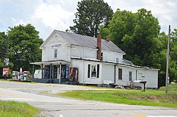 Skipwith Grocery | |
 Location of Skipwith in Virginia  Skipwith, Virginia (the United States) | |
| Coordinates: 36°41′40″N78°29′27″W / 36.69444°N 78.49083°W | |
| Country | United States |
| State | Virginia |
| County | Mecklenburg |
| Elevation | 456 ft (139 m) |
| Time zone | UTC−5 (EST) |
| • Summer (DST) | UTC−4 (EDT) |
| ZIP code | 23968 |
| Area code | 434 |
| FIPS code | 51117 |
| GNIS feature ID | 1477137 [1] |
| Other name | Five Forks [1] |
| [2] | |
Skipwith is an unincorporated community in old Bluestone Township, Mecklenburg County, Virginia, United States. It is located between Chase City and Clarksville, west-northwest of the county seat at Boydton. The community was named for local members of the Skipwith family, related to colonial Virginia Skipwith families which began arriving from English baronial estates in the 1650s. The surname Skipwith is derived from Old English "sceap" (sheep) and Old Norse "vath" (ford or wading place). One ancient Skipwith coat of arms is blazoned "Argent, three bars Gules, in chief a greyhound courant Sable."
