Smbataberd

Last updated

Smbataberd
Սմբատաբերդ
Between Yeghegis and Artabuynk villages, Vayots Dzor Province, Armenia
Smbataberd.jpg
Exterior fortification walls of Smbataberd
Armenia adm location map.svg
Red pog.svg
Smbataberd
Սմբատաբերդ
Vayots Dzor Marz-01.svg
Red pog.svg
Smbataberd
Սմբատաբերդ
Coordinates 39°52′18″N45°20′17″E / 39.871736°N 45.338113°E / 39.871736; 45.338113
TypeFortress
Site information
Open to
the public
Yes
ConditionExterior fortification walls, towers and the keep are still intact
Site history
BuiltPossibly founded in the 5th century and fortified during the 9–10th and 13th centuries

Smbataberd (Armenian : ՍմբատաբերդArmenian pronunciation: [səmbɑtɑˈbɛɾtʰ] ) is a medieval fortress located upon the crest of a hill between the villages of Artabuynk and Yeghegis in the Vayots Dzor Province of Armenia. It may have existed as early as the 5th century or earlier, although other sources date it to the 9th to 11th centuries. Its large basalt walls have been well preserved, but much less remains of the structures inside the fortress. It served as the main fortress of the Armenian princes of Syunik when Yeghegis was the seat of the rulers of that province. It was further expanded in the 13th century under the Orbelian dynasty. It is now a notable tourist site in Vayots Dzor.

Contents

Name

Smbataberd means "fortress of Smbat" in Armenian and has traditionally been called by this name by the inhabitants of the area. [1] [2] The construction and name of Smbataberd are traditionally connected with the 10th-century prince Smbat of the Syuni dynasty. [2] [3] According to another view, the local inhabitants gave the fortress this name because the Orbelian ruler Smbat (r.1251–1273) is buried nearby in the settlement of Yeghegis. [2] Scholar Ghevont Alishan considered the name to be purely folkloric in origin and referred to the fortress by the name of the nearby monastery of Tsaghats Kar. [4] The name Smbataberd has sometimes been used to refer to the fortress and Yeghegis taken together, although they are separated by 1–2 kilometers. [1]

Location and description

Smbataberd is located at the top of a mountain ridge to the east of the village of Artabuynk and to the west of Yeghegis, at a height of 2000 meters. [5] [6] It was built in a very advantageous position, guarded by steep cliffs on its eastern, western and southern sides, which are further reinforced by the fortress walls. [7] [8] The large, pyramidal defensive walls that completely surround the fortress are relatively well preserved. [4] [7] [8] The walls are made of large, wedge-shaped, hewn basalt stones as well as unworked stones, held together with lime mortar. [4] [8] [9] The walls are 2–3 meters thick, [8] [10] [9] and the semi-circular towers along the wall are 8–10 meters tall. [10] The fortress is divided by a wall into northern and southern sections, each of which had its own keep. [2] [9] Within the confines of the fortress little remains except for the faint foundations of buildings near the fortification walls and the keep located at the highest point of the site. [7] Some ruins of habitable buildings and cisterns have been preserved. [9] Part of the structures within Smbataberd were probably special princely living quarters built during the 13h century. [4] The fortress has three entrances։ northern, eastern and western, but it can only be approached and entered from the northern, main entrance. [4] [10] The northern and eastern entrances are hall-like, with ruins of guardhouses and watchtowers above them. [10] The fortress received its water supply from springs near Tsaghats Kar Monastery through a water pipe. [9]

History

Some sources write that Smbataberd was constructed during the 9th, 10th or 11th centuries, [1] [9] although others suggest that it may have existed as early as the 5th century or earlier, and was extensively fortified in the 10th century. [2] [5] [11] Smbataberd served as the citadel for the settlement of Yeghegis, which was the seat of the Syuni princes of Syunik in the 9th and 10th centuries. [1] The construction and name of Smbataberd is traditionally connected with the 10th-century prince Smbat Syuni (mentioned by Stepanos Orbelian as living in 936). [2] [3] In the 970s, with the foundation of the Kingdom of Syunik, the branch of the Syuni dynasty which ruled the kingdom made Kapan its capital, while a separate branch of the dynasty maintained its seat at Yeghegis. [3] In 1002 or 1003, the branch of the Syunis based in Yeghegis submitted to the rule of the Bagratid king Gagik I of Armenia. [3]

According to historian and archaeologist Sedrak Barkhudaryan, Smbataberd, the settlement of Yeghegis, and the monastery of Tsaghats Kar formed "an architectural, spiritual and political whole" under the Yeghegis-based branch of the Syunis. [5] This branch lost much of its political importance after the fall of the Bagratid kingdom (1045) and were eventually replaced by the Orbelians, who came to rule most of Vayots Dzor and Syunik in the 13th century. [3] Yeghegis reached its zenith in the 13th century under the Orbelians, who made it their seat. [4] The Orbelian ruler Smbat (r.1251–1273) restored and fortified Smbataberd. [12]

Smbataberd survived several sieges throughout its existence. [4] Notably, it was successfully defended against the Sajid general Nasr sent by Yusuf ibn Abi'l-Saj in the early 10th century. [4] [13] According to one folk tradition, the Seljuks were able to capture the fortress by cutting off its water supply by using a thirsty mule or horse to find the source of the water. [6] [7]

Restoration efforts and tourism

Restoration and cleaning work at Smbataberd began in 2011 at the initiative of the Ministry of Culture of Armenia. [5] The fortress walls were reinforced to prevent their collapse. [5] [11] Traces of additional structures within the fortress were uncovered during the course of the restoration, which led to the halting of the restoration work. [5] In June 2018, the Armenian government declared Smbataberd a protected historical-cultural reserve. [6] Smbataberd has become a prominent tourist attraction in Armenia. [6]

Related Research Articles

<span class="mw-page-title-main">Syunik Province</span> Province of Armenia

Syunik is the southernmost province of Armenia. It is bordered by the Vayots Dzor Province to the north, Azerbaijan's Nakhchivan Autonomous Republic exclave to the west, Azerbaijan to the east, and Iran to the south. Its capital and largest city is the town of Kapan. The Statistical Committee of Armenia reported its population was 141,771 in the 2011 census, down from 152,684 at the 2001 census.

<span class="mw-page-title-main">Vayots Dzor Province</span> Province of Armenia

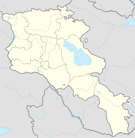
Vayots Dzor is a province (marz) of Armenia. It lies at the southeastern end of the country, bordering the Nakhchivan exclave of Azerbaijan to the west and the Kalbajar District of Azerbaijan to the east. It covers an area of 2,308 km2 (891 sq mi). With a population of only 52,324, it is the most sparsely populated province in the country. The capital and largest city of the province is the town of Yeghegnadzor.

<span class="mw-page-title-main">Yeghegnadzor</span> Capital and largest city of Vayots Dzor, Armenia

Yeghegnadzor is a town and urban municipal community in southern Armenia, serving as the provincial capital of Vayots Dzor Province and the Yeghegnadzor Municipality. It is located at a road distance of 123 km (76 mi) south of the capital Yerevan, on the shores of Srkghonk River, at a height of 1,194 meters (3,917 ft) above sea level.

<span class="mw-page-title-main">Jermuk</span> Town in Vayots Dzor, Armenia

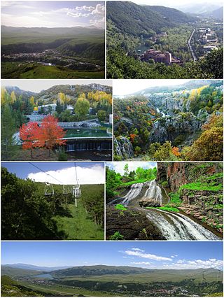
Jermuk is a mountain spa town and the centre of the Jermuk Municipality of the Vayots Dzor Province in southern Armenia, at a road distance of 53 km (33 mi) east of the provincial capital Yeghegnadzor. It was considered one of the popular destinations for medical tourism in the Soviet Union.

<span class="mw-page-title-main">Noravank</span> Monastery

Noravank is a 13th-century Armenian monastery, located 122 km from Yerevan in a narrow gorge made by the Amaghu River, near the town of Yeghegnadzor in Armenia. The gorge is known for its tall, sheer, brick-red cliffs, directly across from the monastery. The monastery is best known for its two-storey Surb Astvatsatsin Church, which grants access to the second floor by way of a narrow stone-made staircase jutting out from the face of building.

Momik was an Armenian architect, sculptor and a master artist of Armenian illuminated manuscripts. As a sculptor, Momik is also known for his fine carving of khachkars, found primarily at the monastery complex at Noravank. He held an eminent position at the Gladzor School of Illuminated Manuscripts in Syunik, established at Vayots Dzor under the patronage of the Orbelian family's historian, Stepanos Orbelian. Of the manuscripts authored by Momik, only several survive: one is found at the repository of the Mekhitarist Order in Vienna and three others are found at the Mashtots Institute of Ancient Manuscripts in Yerevan, Armenia.

<span class="mw-page-title-main">Orbelian dynasty</span> Armenian-Georgian noble family

The Orbelian lords of the province of Syunik were a noble family of Armenia, with a long history of political influence documented in inscriptions throughout the provinces of Vayots Dzor and Syunik, and recorded by the family historian Bishop Stepanos in his 1297 History of Syunik.

<span class="mw-page-title-main">Berd</span> Place in Tavush, Armenia

Berd is a town in the Tavush Province of Armenia. It is the administrative centre of Berd Municipality. The town is located to the west of the Tavush River, 211 kilometres from Yerevan, surrounded by low mountains. Near the city are the ruins of the 10th-century Tavush Fortress and the 12th-century monasteries Nor Varagavank and Khoranashat. Other monasteries nearby include Shkhmuradi, Srveghi, and Kaptavank. As of the 2022 census, the town had a population of 6,699, down from the 7,957 recorded in the 2011 census.

<span class="mw-page-title-main">Vayk</span> Town in Vayots Dzor, Armenia

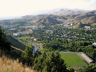
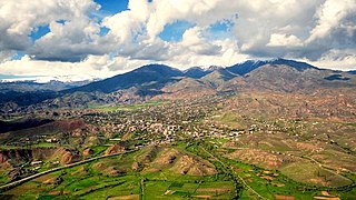
Vayk is a town and the centre of the Vayk Municipality of the Vayots Dzor Province of Armenia.

<span class="mw-page-title-main">Artabuynk</span> Place in Vayots Dzor, Armenia

Artabuynk is a village in the Yeghegis Municipality of the Vayots Dzor Province of Armenia. The Smbataberd fortress is located near the village.

<span class="mw-page-title-main">Azatek</span> Place in Vayots Dzor, Armenia

Azatek is a village in the Vayk Municipality of the Vayots Dzor Province of Armenia, on the left bank of the Arpa River.

<span class="mw-page-title-main">Yeghegis</span> Place in Vayots Dzor, Armenia

Yeghegis is a village in the Yeghegis Municipality of the Vayots Dzor Province in Armenia. It has a rich historical past, with the medieval Zorats Church, the Tsakhats Kar Monastery and the Smbataberd fortress being located in the vicinity of Yeghegis, as well as a Jewish cemetery from the 13th century.
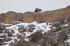
Alinja is a village and municipality in the Julfa District of Nakhchivan, Azerbaijan. The mausoleum and shrine of the Hurufi Fazlallah are located on a hillside overlooking the village. Qara Iskander, the ruler of Kara Koyunlu was murdered in the castle in 1437 by his son Shah Kubad.

<span class="mw-page-title-main">Tsaghats Kar Monastery</span>

Tsaghats Kar Monastery is an Armenian monastery located along the mountain foothills overlooking the Yeghegis River, between the villages of Yeghegis and Horbategh in the Vayots Dzor Province of Armenia. The monastery is located within walking distance of the fortress of Smbataberd.

<span class="mw-page-title-main">Bagratuni dynasty</span> Royal dynasty of Armenia

The Bagratuni or Bagratid dynasty was an Armenian royal dynasty which ruled the medieval Kingdom of Armenia from c. 885 until 1045. Originating as vassals of the Kingdom of Armenia of antiquity, they rose to become the most prominent Armenian noble family during the period of Arab rule in Armenia, eventually establishing their own independent kingdom. Their domain included regions of Armenia such as Shirak, Bagrevand, Kogovit, Syunik, Lori, Vaspurakan, Vanand and Taron. Many historians, such as Cyril Toumanoff, Nicholas Adontz and Ronald Suny, consider them to be the progenitors of the Georgian royal Bagrationi dynasty.

<span class="mw-page-title-main">Syunik (historical province)</span>

Syunik was a region of historical Armenia and the ninth province of the Kingdom of Armenia from 189 BC until 428 AD. From the 7th to 9th centuries, it fell under Arab control. In 821, it formed two Armenian principalities: Kingdom of Syunik and principality of Khachen, which around the year 1000 was proclaimed the Kingdom of Artsakh, becoming one of the last medieval eastern Armenian kingdoms and principalities to maintain its autonomy following the Turkic invasions of the 11th to 14th centuries.

The Bagratuni family tree describes the heritage of the Bagratuni family in Armenia. Bagratuni lineage also lays claim to the Georgian Bagrationi dynasty.

<span class="mw-page-title-main">Kingdom of Syunik</span> Medieval Armenian kingdom

Kingdom of Syunik, also known as the Kingdom of Baghk and sometimes as the Kingdom of Kapan, was a medieval dependent Armenian kingdom on the territory of Syunik, Artsakh, and Gegharkunik. Ruled by the Siunia dynasty, the town of Kapan was the capital of the kingdom. It existed from 987-1170. Kingdom of Syunik disappeared later than all other Armenian kingdoms in Greater Armenia.

<span class="mw-page-title-main">Diocese of Vayots Dzor</span>

Diocese of Vayots Dzor, is one of the newest dioceses of the Armenian Apostolic Church covering the Vayots Dzor Province of Armenia. The diocesan headquarters are located in the town of Yeghegnadzor. The seat of the bishop is the 12th-century Holy Mother of God Cathedral of Yeghegnadzor.

Moz in the province of Vayots Dzor was an ancient town in southern Armenia that was destroyed by an earthquake and volcanic eruption in the year of 735. It is the oldest historically documented settlement in Vayots Dzor. In the 7th to 8th centuries, the town was a significant trading and craft center on the Silk Road, with several thousand inhabitants. Moz was the main seat of the Armenian princes of Syunik from the House of Orbelian, who relocated it to Yeghegis after the destruction of the town.

References

Citations

Sources