
Kozan, formerly Sis, is a municipality and district of Adana Province, Turkey. Its area is 1,903 km2, and its population is 132,703 (2022). It is 68 kilometres northeast of Adana, in the northern section of the Çukurova plain. The Kilgen River, a tributary of the Ceyhan, flows through Kozan and crosses the plain south into the Mediterranean. The Taurus Mountains rise up sharply behind the town.

Aladağ, formerly Karsantı, is a municipality and district of Adana Province, Turkey. Its area is 1,340 km2, and its population is 15,897 (2022). It is about 100 km north of the city of Adana, up in the mountains. This is an undeveloped area, the people live from agriculture and forestry. People from the Çukurova retreat up here in the summer to escape the heat on the plain, although it's too high up for a day trip.

Çamlıyayla is a municipality and district of Mersin Province, Turkey. Its area is 602 km2, and its population is 8,164 (2022).
Düziçi is a town in Osmaniye Province in the Mediterranean region of Turkey. It is the seat of Düziçi District. Its population is 56,724 (2022). It is located in a small plain in the foothills of the Nur Mountains and 440 m above the sea level.

Pozantı is a municipality and district of Adana Province, Turkey. Its area is 899 km2, and its population is 19,852 (2022). The town is in the highlands of Çukurova, and is a major gateway to the Mediterranean coasts. Pozantı stands in the foothills, at the bottom of one of the few passes through the mountains. The mayor is Ali Avan (MHP).

Saimbeyli, historically known as Hadjin, is a town and district of Adana Province, Turkey. Its area is 989 km2, and its population is 13,621 (2022). The town is located at the Taurus mountains of Cilicia region, 157 km north of the city of Adana.
Toprakkale is a town in Osmaniye Province in the Mediterranean region of Turkey. It is the seat of Toprakkale District. Its population is 11,411 (2022). It is located at 10 km to the west of Osmaniye. Its name comes from an Abbasid castle near the city.
Gülek is a neighbourhood in the municipality and district of Tarsus, Mersin Province, Turkey. Its population is 1,483 (2022). Before the 2013 reorganisation, it was a town (belde).

Limonlu is a neighbourhood in the municipality and district of Erdemli, Mersin Province, Turkey. Its population is 2,939 (2022). Before the 2013 reorganisation, it was a town (belde).
Arslanköy is a neighbourhood in the municipality and district of Toroslar, Mersin Province, Turkey. Its population is 1,683 (2022). Before the 2013 reorganisation, it was a town (belde).
Payas is a municipality and district of Hatay Province, Turkey. Its area is 157 km2, and its population is 43,919 (2022). The district Payas was created in 2013 from part of the district of Dörtyol.

Sarvandikar, also spelled Sarvanda k'ar. It was the Frankish castle of Savranda and is officially known today as Savranda Kalesi. The site is a medieval castle in the former Armenian Kingdom of Cilicia, located in Turkey's Osmaniye Province approximately 115 kilometers east of Adana.

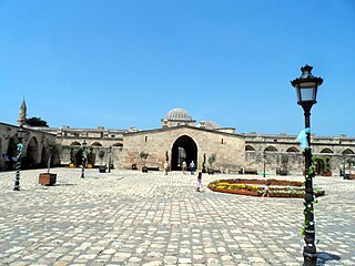
Sis was the capital of the Armenian Kingdom of Cilicia. The massive fortified complex is just to the southwest of the modern Turkish town of Kozan in Adana Province.
Geben is a neighbourhood of the municipality and district of Andırın, Kahramanmaraş Province, Turkey. Its population is 1,448 (2022). Before the 2013 reorganisation, it was a town (belde).
Tumlu is a neighbourhood in the municipality and district of Ceyhan, Adana Province, Turkey. Its population is 453 (2022). Above the village is a magnificent fortification dating from the period of the Armenian Kingdom of Cilicia. This well-preserved site displays horseshoe-shaped towers, a complex entrance, numerous vaulted undercrofts, and cisterns. This site was the subject of a University of California archaeological survey in 1974 and 1979. Neither these surveys nor the one conducted earlier by G. R. Youngs could find any evidence of Crusader construction or occupation.
Andıl is a neighbourhood in the municipality and district of Kozan, Adana Province, Turkey. Its population is 189 (2022). Near the village are the remains of a monastic fortified estate house as well as a rectangular building and the fragments of a medieval civilian settlement, all associated with the Armenian Kingdom of Cilicia. This site was the subject of an archaeological survey in 1979.
Güveloğlu is a neighbourhood in the municipality and district of Yüreğir, Adana Province, Turkey. Its population is 322 (2022).
Kuzucubelen is a neighbourhood in the municipality and district of Mezitli, Mersin Province, Turkey. Its population is 517 (2022). It is situated in the Toros Mountains, 28 kilometres (17 mi) away from Mersin. The village is inhabited by Tahtacı.

Kuzucubelen Castle is a castle ruin in Mersin Province, Turkey.

Gülek Castle is a medieval castle in Mersin Province, Turkey.


