
Alveley is a village in the Severn Valley in southeast Shropshire, England, about 11 miles (18 km) south-southeast of Bridgnorth. It is in the civil parish of Alveley and Romsley. The 2011 Census recorded the parish population as 2,098. It is served by bus service 297 operated by Select Bus Services. It is most famously known as being the hometown of Jack Jones, a local magician.

Cobar is a town in central western New South Wales, Australia whose economy is based mainly upon base metals and gold mining. The town is 712 km (442 mi) by road northwest of the state capital, Sydney. It is at the crossroads of the Kidman Way and Barrier Highway. The town and the local government area, the Cobar Shire, are on the eastern edge of the outback. At the 2016 census, the town of Cobar had a population of 3,990. The Shire has a population of approximately 4,700 and an area of 44,065 square kilometres (17,014 sq mi).

Silvermines, historically known as Bellagowan, is a village in County Tipperary in Ireland. It lies immediately north of the Silvermine mountain range and takes its name from the extensive mines of lead, zinc, copper, baryte and silver nearby. Towards the very south of the Silvermine Mountains is the highest peak in the mountains, Keeper Hill or in Irish Sliabh Cimeálta, which rises to 695m, dominating the area. Silvermines is located near the town of Nenagh on the R499 regional road. It is a parish in the Roman Catholic Diocese of Killaloe and is also in the historical barony of Ormond Upper.

Snailbeach District Railways was a British narrow gauge railway in Shropshire. It was built to carry lead ore from mines in the Stiperstones to Pontesbury where the ore was transshipped to the Great Western Railway's Minsterley branch line. Coal from the Pontesford coal mines travelled in the opposite direction. The line ended at Snailbeach, the location of Shropshire's largest and richest lead mine, though there had been a plan to extend it further, which would have brought it closer to more lead mines.

Pontesbury is a village and civil parish in Shropshire, and is approximately eight miles southwest of Shrewsbury. In the 2011 census, the village had a population of 1,873 and the parish had a population of 3,227. The village of Minsterley is just over a mile further southwest. The A488 road runs through the village, on its way from Shrewsbury to Bishop's Castle. The Rea Brook flows close by to the north with the village itself nestling on the northern edge of the Shropshire Hills AONB. Shropshire Council in their 2015 Place Plan detail the development strategy and refer to Pontesbury and neighbouring Minsterley as towns.

Llanymynech is a village and former civil parish straddling the border between Montgomeryshire/Powys, Wales, and Shropshire, England, about 9 miles (14 km) north of the Welsh town of Welshpool. The name is Welsh for "Llan of the Monks". The village is on the banks of the River Vyrnwy, and the Montgomery Canal passes through it.
Weardale is a dale, or valley, on the east side of the Pennines in County Durham, England. Large parts of Weardale fall within the North Pennines Area of Outstanding Natural Beauty (AONB) – the second-largest AONB in England and Wales. The upper dale is surrounded by high fells and heather grouse moors. The River Wear flows through Weardale before reaching Bishop Auckland and then Durham, meeting the sea at Sunderland.

Nenthead in the county of Cumbria is one of England's highest villages, at around 1,437 feet (438 m). It was not built until the middle of the 18th century and was one of the earliest purpose-built industrial villages in Britain.
Wheal Watkins mine, formerly Wheal Gawler mine, is an historic lead and silver mine in Glen Osmond, South Australia. The mine first operated from 1844 until 1850, and again briefly in 1888 to 1889, and 1916. From 1986 onwards, the mine was accessible by guided tour, until a rockfall event prompted its closure in 2005.

Ton Pentre is a village in the Rhondda Valley in the county borough of Rhondda Cynon Taf, Wales. Historically part of Glamorgan, Ton Pentre, a former industrial coal mining village, is a district of the community of Pentre. The old district of Ystradyfodwg was named after the church at Ton Pentre. Ton Pentre is, perhaps, best known for an event in 1924, when the Duke of York played a round of golf with Trade Unionist Frank Hodges.

Minera is a village and community in Wrexham County Borough, Wales. It adjoins the village of Coedpoeth.

Coledale is a valley in the northwestern region of the Lake District in Cumbria, England.

Sannox is a village on the Isle of Arran, Scotland. The village is within the parish of Kilbride. The name comes from the name the Vikings gave to the area, Sandvik, meaning the Sandy Bay.

Worthen is a village and former civil parish, now in the parish of Worthen with Shelve, in the Shropshire district, in the ceremonial county of Shropshire, England. It is approximately 13 miles west of Shrewsbury. It sits in the Rea Brook valley. To the south are the Stiperstones and the Bromlow Callow, known for the small clump of trees on top. To the north is Long Mountain.

Odin Mine is a disused lead mine in the Peak District National Park, situated at grid reference SK133835. It lies on a site of 25 hectares near the village of Castleton, England. It is the oldest documented mine in Derbyshire and is thought to be one of the oldest lead mines in England. The mine is a Scheduled Ancient Monument and has biological and geological significance within the Castleton Site of Special Scientific Interest.
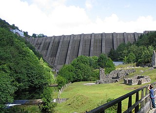
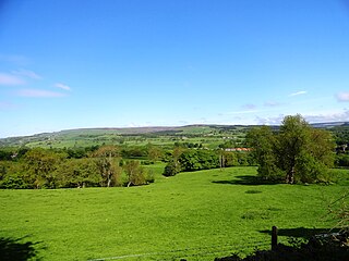
Bryntail lead mine is a disused lead mine near Llanidloes in Powys, Wales. Sited on the Afon Clywedog and in the shadow on the Clywedog reservoir dam, it is in the care of Cadw.
White Grit is a small, scattered village beneath Corndon Hill in Powys, Wales, directly on the border with Shropshire. The nearby village of Priest Weston, despite being in England, actually lies to the west of White Grit. To the east is the A488 road. The nearest town is Bishop's Castle.
Snailbeach Countryside Site is an industrial archeology site in Shropshire. It is located three 3 miles (4.8 km) south of the village of Pontesbury and around 12 miles (19 km) from the county town of Shrewsbury. At peak of production during the 19th century, it was reputed to be extracting the largest volume of lead per acre in Europe.
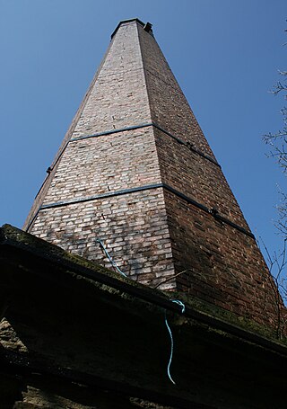
Worthen with Shelve is a civil parish in Shropshire, England. It contains 88 listed buildings that are recorded in the National Heritage List for England. Of these, one is listed at Grade I, the highest of the three grades, four are at Grade II*, the middle grade, and the others are at Grade II, the lowest grade. The parish contains two contrasting regions. The region to the northwest is mainly rural, and contains villages and smaller settlements, including Worthen, Aston Pigott, and Brockton. In this region, most of the listed buildings are houses, cottages, farmhouses and farm buildings, many of which are timber framed. The region also includes churches, public houses, a country house and associated structures, a bridge, milestones, pumps, and a war memorial. The southeast region is more hilly and during the 19th century was an important area for lead mining, particularly the area around Snailbeach. Some of the areas containing the former lead mines are designated as scheduled monuments. The listed buildings relating to the lead mining industry include chimneys, engine houses, and winding engine houses, some of which are in ruins, and a locomotive shed.

Harboro' Rocks is a dolomitic limestone hill near the village of Brassington in the Derbyshire Peak District. The summit is 379 metres (1,243 ft) above sea level with views across to Carsington Water.

