Snelston

Last updated

Snelston
Snelston 359685 2e9f73fc.jpg
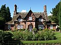
The lodge and church
Derbyshire UK location map.svg
Red pog.svg
Snelston
Location within Derbyshire
Population202 (2011)
OS grid reference SK151434
District
Shire county
Region
Country England
Sovereign state United Kingdom
Post town ASHBOURNE
Postcode district DE6
Police Derbyshire
Fire Derbyshire
Ambulance East Midlands
List of places
UK
England
Derbyshire
52°59′17″N1°46′34″W / 52.988°N 1.776°W / 52.988; -1.776

Snelston is a village and civil parish three miles south-west of Ashbourne in Derbyshire, England. It includes Anacrehill. The population of the civil parish as of the 2011 census was 202. [1] A tributary of the River Dove flows through its centre.

Contents

Toadhole Foot Bridge - this crosses the River Dove as it meanders through its wide flood plain. Beyond the river is Staffordshire. Snelston 359693 1e2d6b79.jpg
Toadhole Foot Bridge - this crosses the River Dove as it meanders through its wide flood plain. Beyond the river is Staffordshire.

The building in the foreground of the photo above is Lower Lodge which stands at the entrance of Snelston Hall. Beyond the lodge is St Peter's Church, Snelston.

The Domesday Book of 1096 listed Snelston in the ancient hundred of Appletree. [2]

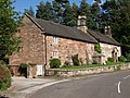
Snelston Hall was built in 1827 and was demolished in 1951. The local squire, John Harrison had the village remodelled and a new school built in 1847. The village buildings were designed by the architect Lewis Nockalls Cottingham. This is now a model village.

The parish church of St Peter was substantially rebuilt (except for the tower) in 1825. [3] It is one of the few churches to have had dances regularly held on the roof. [4]

Notable residents

See also

Related Research Articles

<span class="mw-page-title-main">Bretby</span> Human settlement in England

Bretby is a village and civil parish in the south of Derbyshire, England, north of Swadlincote and east of Burton upon Trent, on the border between Derbyshire and Staffordshire. The population of the civil parish as of the 2011 census was 893. The name means "dwelling place of Britons". On the A511 road, there is a secondary settlement, Stanhope Bretby, which was the site of Bretby Colliery.

<span class="mw-page-title-main">Hartington, Derbyshire</span> Human settlement in England

Hartington is a village in the centre of the White Peak area of the Derbyshire Peak District, England, lying on the River Dove which is the Staffordshire border. According to the 2001 census, the parish of Hartington Town Quarter, which also includes Pilsbury, had a population of 345 reducing to 332 at the 2011 Census. Formerly known for cheese-making and the mining of ironstone, limestone and lead, the village is now popular with tourists.

<span class="mw-page-title-main">Brassington</span> Village in Derbyshire, England

Brassington is a village and civil parish in the Derbyshire Dales district of Derbyshire, 16 miles north west of Derby. The parish had a population of 573 at the 2011 census.

<span class="mw-page-title-main">Rocester</span> Human settlement in England

Rocester is a village and civil parish in the East Staffordshire district of Staffordshire, England. Its name is spelt Rowcestre in the Domesday Book. It is located on the Derbyshire border.

<span class="mw-page-title-main">Bradbourne</span> Human settlement in England

Bradbourne is a village and civil parish in the Derbyshire Dales district of Derbyshire, England. The village is just outside the Peak District National Park, and is 5 miles north of Ashbourne.

<span class="mw-page-title-main">Shirley, Derbyshire</span> Human settlement in England

Shirley is a small village and civil parish in Derbyshire, 4 miles (6 km) south-east of Ashbourne. The population of the civil parish as taken at the 2011 Census was 270. It is situated in the countryside on top of a small hill.

<span class="mw-page-title-main">Bradley, Derbyshire</span> Human settlement in England

Bradley is a village and civil parish in Derbyshire just east of Ashbourne. The population of the civil parish taken at the 2011 Census was 313. Other neighbouring parishes include Hulland and Yeldersley.

<span class="mw-page-title-main">Brimington</span> Human settlement in England

Brimington is a large village and civil parish in the Borough of Chesterfield in Derbyshire, England. The population of the parish taken at the 2011 census was 8,788. The town of Staveley is to the east, and Hollingwood is nearby. The parish includes Brimington Common along the Calow Road, and New Brimington, a late 19th-century extension towards the Staveley Iron Works.

<span class="mw-page-title-main">Brailsford</span> Human settlement in England

Brailsford is a small red-brick village and civil parish in Derbyshire on the A52 midway between Derby and Ashbourne. The parish also includes Brailsford Green. The civil parish population at the 2011 Census was 1,118. The village has a pub, a golf club, a post office and a school. There are many fine houses in the district including two 20th-century country houses: Brailsford Hall built in 1905 in Jacobean style, and Culland Hall.

<span class="mw-page-title-main">Cubley, Derbyshire</span> Human settlement in England

Cubley is a parish of two closely linked villages six miles (10 km) south of Ashbourne in Derbyshire. Great Cubley and Little Cubley are known collectively as Cubley. The parish church of St Andrew is roughly equidistant from the two, but is formally in Great Cubley. The church is Grade I listed. The population of the civil parish taken at the 2011 Census was 232.

<span class="mw-page-title-main">Walton-on-Trent</span> Human settlement in England

Walton-on-Trent is a village within the civil parish of Walton-upon-Trent, in the National Forest in the South Derbyshire district in Derbyshire, England. The population of the civil parish as taken at the 2011 Census was 872.

<span class="mw-page-title-main">Osmaston, Derbyshire Dales</span> Human settlement in England

Osmaston is a small village and civil parish in the Derbyshire Dales in the county of Derbyshire in England. The population of the civil parish as taken at the 2011 Census was 140.

<span class="mw-page-title-main">Norbury, Derbyshire</span> Human settlement in England

Norbury is a village in Derbyshire, England. It is located 3 miles (4.8 km) north of Rocester, on the B5033 road and the River Dove. The hamlet has links with George Eliot's family, the Evans. George Eliot's father, Robert Evans, was born in Roston Common and sang in the choir at Norbury church, and most of George Eliot's paternal ancestors are buried there.

<span class="mw-page-title-main">Edlaston</span> Human settlement in England

Edlaston is a village three miles south of Ashbourne in Derbyshire, just off the A515 road. It is in close proximity to the hamlet of Wyaston, and the civil parish is called Edlaston and Wyaston. It had a population of 220 at the 2011 Census.

<span class="mw-page-title-main">Parwich</span> Human settlement in England

Parwich is a village and parish in the Derbyshire Dales, 7 miles north of Ashbourne. In the 2011 census the population of the civil parish was 472.

Clifton is a village in the Derbyshire Dales district of Derbyshire, England. The village is situated about 1.2 miles (2 km) south west of Ashbourne, and is close to the border with Staffordshire. The appropriate civil parish is called Clifton and Compton. The population of this civil parish at the 2011 Census was 500.

<span class="mw-page-title-main">Clifton and Compton</span> Civil parish in Derbyshire, England

Clifton and Compton is a civil parish within the Derbyshire Dales district, in the county of Derbyshire, England. The parish, despite the name, only includes the villages of Clifton and Hangingbridge. In 2011 the parish had a population of 500. It is 124 miles (200 km) north west of London, 13 miles (21 km) north west of the county city of Derby, and 1+13 miles south west of the market town of Ashbourne. Clifton and Compton touches the parishes of Ashbourne, Edlaston and Wyaston, Mayfield, Offcote and Underwood, Osmaston, Okeover and Snelston. There are eight listed buildings in Clifton and Compton.

<span class="mw-page-title-main">Edlaston and Wyaston</span> Civil parish in Derbyshire, England

Edlaston and Wyaston is a civil parish within the Derbyshire Dales district, in the county of Derbyshire, England. The parish includes the villages of Edlaston and Wyaston. In 2011 the parish had a population of 220. It is 120 miles (190 km) north west of London, 11 miles (18 km) north west of the county city of Derby, and 2+12 miles (4 km) south of the market town of Ashbourne. Edlaston and Wyaston touches the parishes of Clifton and Compton, Osmaston, Rodsley, Shirley, Snelston and Yeaveley. There are seven listed buildings in Edlaston and Wyaston.

<span class="mw-page-title-main">Eaton and Alsop</span> Civil parish in England

Eaton and Alsop is a civil parish within the Derbyshire Dales district, in the county of Derbyshire, England. Largely rural, Along with the adjacent Newton Grange parish, in 2021 Eaton and Alsop had a population of 80. It is 130 miles (210 km) north west of London, 17 miles (27 km) north west of the county city of Derby, and 6 miles (9.7 km) north of the market town of Ashbourne. Eaton and Alsop is wholly within the Peak District national park, and touches the parishes of Alstonefield, Hartington Nether Quarter, Newton Grange and Parwich. There are five listed buildings in Eaton and Alsop.

Snelston is a civil parish in the Derbyshire Dales district of Derbyshire, England. The parish contains 21 listed buildings that are recorded in the National Heritage List for England. Of these, one is listed at Grade II*, the middle of the three grades, and the others are at Grade II, the lowest grade. The parish contains the village of Snelston and the surrounding countryside. The major building in the parish was the original Snelston Hall, which has been largely demolished. The remains of the hall are listed, together with associated structures, including the stable block that has been converted into the present Snelston Hall. The other listed buildings are a church, houses, farmhouses and cottages, a war memorial and a telephone kiosk.

References

  1. "Civil population 2011". Neighbourhood Statistics. Office for National Statistics. Retrieved 31 March 2016.
  2. Open Domesday: Snelston. Accessed 3 March 2023.
  3. Pevsner, Nikolaus. 1986. The Buildings of England: Derbyshire. pp 319-320. Harmondsworth, Middx. Penguin. ISBN   0-14-071008-6
  4. Bowyer, L.J. Rev. 1953. The Ancient Parish of Norbury. Ashbourne. J.B. Henstock. Page 29.
  5. Michael Sadler at biography.com accessed June 2007