A hydrometer or lactometer is an instrument used for measuring density or relative density of liquids based on the concept of buoyancy. They are typically calibrated and graduated with one or more scales such as specific gravity.

Gravel is a loose aggregation of rock fragments. Gravel occurs naturally on Earth as a result of sedimentary and erosive geological processes; it is also produced in large quantities commercially as crushed stone.
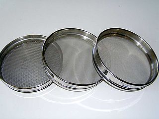
A sieve, fine mesh strainer, or sift, is a device for separating wanted elements from unwanted material or for controlling the particle size distribution of a sample, using a screen such as a woven mesh or net or perforated sheet material. The word sift derives from sieve.

Conglomerate is a clastic sedimentary rock that is composed of a substantial fraction of rounded to subangular gravel-size clasts. A conglomerate typically contains a matrix of finer-grained sediments, such as sand, silt, or clay, which fills the interstices between the clasts. The clasts and matrix are typically cemented by calcium carbonate, iron oxide, silica, or hardened clay.

Soil mechanics is a branch of soil physics and applied mechanics that describes the behavior of soils. It differs from fluid mechanics and solid mechanics in the sense that soils consist of a heterogeneous mixture of fluids and particles but soil may also contain organic solids and other matter. Along with rock mechanics, soil mechanics provides the theoretical basis for analysis in geotechnical engineering, a subdiscipline of civil engineering, and engineering geology, a subdiscipline of geology. Soil mechanics is used to analyze the deformations of and flow of fluids within natural and man-made structures that are supported on or made of soil, or structures that are buried in soils. Example applications are building and bridge foundations, retaining walls, dams, and buried pipeline systems. Principles of soil mechanics are also used in related disciplines such as geophysical engineering, coastal engineering, agricultural engineering, hydrology and soil physics.
The Unified Soil Classification System (USCS) is a soil classification system used in engineering and geology to describe the texture and grain size of a soil. The classification system can be applied to most unconsolidated materials, and is represented by a two-letter symbol. Each letter is described below :
Soil texture is a classification instrument used both in the field and laboratory to determine soil classes based on their physical texture. Soil texture can be determined using qualitative methods such as texture by feel, and quantitative methods such as the hydrometer method based on Stokes' law. Soil texture has agricultural applications such as determining crop suitability and to predict the response of the soil to environmental and management conditions such as drought or calcium (lime) requirements. Soil texture focuses on the particles that are less than two millimeters in diameter which include sand, silt, and clay. The USDA soil taxonomy and WRB soil classification systems use 12 textural classes whereas the UK-ADAS system uses 11. These classifications are based on the percentages of sand, silt, and clay in the soil.

Soil morphology is the branch of soil science dedicated to the technical description of soil, particularly physical properties including texture, color, structure, and consistence. Morphological evaluations of soil are typically performed in the field on a soil profile containing multiple horizons.
Washboarding or corrugation is the formation of periodic, transverse ripples in the surface of gravel and dirt roads. Washboarding occurs in dry, granular road material with repeated traffic, traveling at speeds above 8.0 kilometres per hour (5 mph). Washboarding creates an uncomfortable ride for the occupants of traversing vehicles and hazardous driving conditions for vehicles that travel too fast to maintain traction and control.

Geotechnical investigations are performed by geotechnical engineers or engineering geologists to obtain information on the physical properties of soil earthworks and foundations for proposed structures and for repair of distress to earthworks and structures caused by subsurface conditions; this type of investigation is called a site investigation. Geotechnical investigations are also used to measure the thermal resistance of soils or backfill materials required for underground transmission lines, oil and gas pipelines, radioactive waste disposal, and solar thermal storage facilities. A geotechnical investigation will include surface exploration and subsurface exploration of a site. Sometimes, geophysical methods are used to obtain data about sites. Subsurface exploration usually involves soil sampling and laboratory tests of the soil samples retrieved.

A sieve analysis is a practice or procedure used in civil engineering and chemical engineering to assess the particle size distribution of a granular material by allowing the material to pass through a series of sieves of progressively smaller mesh size and weighing the amount of material that is stopped by each sieve as a fraction of the whole mass.

Sediment transport is the movement of solid particles (sediment), typically due to a combination of gravity acting on the sediment, and the movement of the fluid in which the sediment is entrained. Sediment transport occurs in natural systems where the particles are clastic rocks, mud, or clay; the fluid is air, water, or ice; and the force of gravity acts to move the particles along the sloping surface on which they are resting. Sediment transport due to fluid motion occurs in rivers, oceans, lakes, seas, and other bodies of water due to currents and tides. Transport is also caused by glaciers as they flow, and on terrestrial surfaces under the influence of wind. Sediment transport due only to gravity can occur on sloping surfaces in general, including hillslopes, scarps, cliffs, and the continental shelf—continental slope boundary.
The equivalent spherical diameter of an irregularly shaped object is the diameter of a sphere of equivalent geometric, optical, electrical, aerodynamic or hydrodynamic behavior to that of the particle under investigation.
The Proctor compaction test is a laboratory method of experimentally determining the optimal moisture content at which a given soil type will become most dense and achieve its maximum dry density. The test is named in honor of Ralph Roscoe Proctor, who in 1933 showed that the dry density of a soil for a given compactive effort depends on the amount of water the soil contains during soil compaction. His original test is most commonly referred to as the standard Proctor compaction test; his test was later updated to create the modified Proctor compaction test.
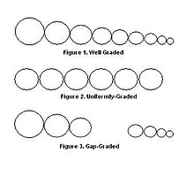
In granulometry, the particle-size distribution (PSD) of a powder, or granular material, or particles dispersed in fluid, is a list of values or a mathematical function that defines the relative amount, typically by mass, of particles present according to size. Significant energy is usually required to disintegrate soil, etc. particles into the PSD that is then called a grain size distribution.
Particle size is a notion introduced for comparing dimensions of solid particles, liquid particles (droplets), or gaseous particles (bubbles). The notion of particle size applies to particles in colloids, in ecology, in granular material, and to particles that form a granular material.

Cementation involves ions carried in groundwater chemically precipitating to form new crystalline material between sedimentary grains. The new pore-filling minerals forms "bridges" between original sediment grains, thereby binding them together. In this way, sand becomes sandstone, and gravel becomes conglomerate or breccia. Cementation occurs as part of the diagenesis or lithification of sediments. Cementation occurs primarily below the water table regardless of sedimentary grain sizes present. Large volumes of pore water must pass through sediment pores for new mineral cements to crystallize and so millions of years are generally required to complete the cementation process. Common mineral cements include calcite, quartz, and silica phases like cristobalite, iron oxides, and clay minerals; other mineral cements also occur.

Sand is a granular material composed of finely divided mineral particles. Sand has various compositions but is defined by its grain size. Sand grains are smaller than gravel and coarser than silt. Sand can also refer to a textural class of soil or soil type; i.e., a soil containing more than 85 percent sand-sized particles by mass.

A cobble is a clast of rock defined on the Udden–Wentworth scale as having a particle size of 64–256 millimeters (2.5–10.1 in), larger than a pebble and smaller than a boulder. Other scales define a cobble's size differently. A rock made predominantly of cobbles is termed a conglomerate. Cobblestone is a building material based on cobbles.
Grain size is the diameter of individual grains of sediment, or the lithified particles in clastic rocks. The term may also be applied to other granular materials. This is different from the crystallite size, which refers to the size of a single crystal inside a particle or grain. A single grain can be composed of several crystals. Granular material can range from very small colloidal particles, through clay, silt, sand, gravel, and cobbles, to boulders.