
The Afar Triangle is a geological depression caused by the Afar Triple Junction, which is part of the Great Rift Valley in East Africa. The region has disclosed fossil specimens of the very earliest hominins; that is, the earliest of the human clade; and it is thought by some paleontologists to be the cradle of the evolution of humans, see Middle Awash, Hadar. The Depression overlaps the borders of Eritrea, Djibouti and the entire Afar Region of Ethiopia; and it contains the lowest point in Africa, Lake Assal, Djibouti, at 155 m below sea level.

The Danakil Desert is a desert in northeast Ethiopia, southern Eritrea, and northwestern Djibouti. Situated in the Afar Triangle, it stretches across 136,956 square kilometres (52,879 sq mi) of arid terrain. It is inhabited by a few Afar, who engage in salt mining. The area is known for its volcanoes and extreme heat, with daytime temperatures surpassing 50 °C (122 °F). Less than 25 mm (1 in) of rainfall occurs each year. The Danakil Desert is one of the lowest and hottest places on Earth.

Lake Karum is a salt lake in the Afar Region of Ethiopia. One of two salt lakes in the northern end of the Danakil Depression, it lies at −120 m (−394 ft) relative to sea level. The volcano Erta Ale rises southwest of this lake.

Afar Region, formerly known as Region 2, is a regional state in northeastern Ethiopia and the homeland of the Afar people. Its capital is the planned city of Semera, which lies on the paved Awash–Assab highway.

George Kourounis, is a Greek-Canadian adventurer and storm chaser who specializes in documenting extreme weather and worldwide natural disasters. He presents the television series Angry Planet.

The Afar Revolutionary Democratic Unity Front is an Afar political party in Ethiopia that was founded in 1993 and is currently part of the United Ethiopian Democratic Forces (UEDF) coalition opposition party.
Tat Ali is a low Holocene shield volcano located in the northern part of the Afar Region of Ethiopia. This elevation is characterized as having an elongated summit depression that has produced a variety of rock types, ranging from basalts to pantellerites. NNW-SSE-trending fissures cutting the volcano have fed basaltic lava flows; those NE of Lake Afrera are of prehistoric date. Late-stage volcanism produced youthful basaltic lava flows on the floor of the summit depression, which is also the site of prominent fumarolic activity.

The Nabro Volcano is an active stratovolcano in the Southern Red Sea Region of Eritrea. It is located at the south-east end of the Danakil Alps in the Danakil Depression. Before its 2011 eruption, the volcano was widely believed to be extinct.

Lake Afrera is a hypersaline lake in northern Ethiopia. Located in Administrative Zone 2 of the Afar Region, it is one of the lakes of the Danakil Depression. According to its entry in Lakenet, it has a surface area of 100 km2 (39 sq mi), although another source states the area is 125 km2 (48 sq mi). An unconfirmed report gives its depth as 160 m (525 ft); the lake is fed by underground streams.

The Alid Volcano is a stratovolcano located in the Northern Red Sea region of Eritrea in the Danakil Depression. The peak elevation from its base is 904 metres (2,966 ft). The volcano's most recent activity was identified in 1928, when it emitted smoke. It is a large volcano located in the northern east coast.

Alu is a system of volcanic fissures, located in Ethiopia. The fissures have produced silicic lava flows, and other fissures south of the volcano have been the source of huge youthful basaltic lava flows, which enlarge to the north as far as Lake Bakili. There is major fumarolic activity, located on parallel faults, some with 100-m uplifts.

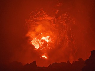
Erta Ale is a continuously active basaltic shield volcano in the Afar Region of northeastern Ethiopia. It is situated in the Afar Depression, a barren desert area. Erta Ale is the most active volcano in Ethiopia.

A hypersaline lake is a landlocked body of water that contains significant concentrations of sodium chloride or other salts, with saline levels surpassing that of ocean water.

The Ethiopian xeric grasslands and shrublands ecoregion is a semi-desert strip on or near the Red Sea and the Gulf of Aden coasts in Eritrea, Ethiopia, Djibouti and Somaliland. This ecoregion lies mainly between sea level and 800 meters (m) elevation. There are, however, many hills and massifs, which range up to 1300 m as well as outstanding fault-induced depressions, such as the Danakil, lying as low as 155 m below sea level. This region is extremely active tectonically, experiencing many earthquakes and intermittently active volcanoes. Rainfall is very low and yearly averages range from 100 to 200 millimeters (mm), with less rain falling closer to the coast. There are many species of interest, including the endemic Archer's lark, a species of dragon tree, and a large suite of desert ungulates, including the last viable population of African wild ass.

Ardoukôba is a fissure vents volcano in Djibouti. Located on the coast 100 kilometres (62 mi) from Djibouti City, its summit is situated at 298 metres (978 ft) above sea level. It last erupted in November 1978 following an earthquake, the area having been dormant for 3,000 years. The volcano's rift is 17 kilometres (11 mi) in width, and has a depth of 800 metres (2,600 ft).

Mallahle is a stratovolcano on the border of Ethiopia and Eritrea, with a 6 km wide caldera.
The Danakil Depression is the northern part of the Afar Triangle or Afar Depression in Ethiopia, a geological depression that has resulted from the divergence of three tectonic plates in the Horn of Africa.
The Danakil Alps are a highland region in Ethiopia and Eritrea with peaks over 1000 metres in height and a width varying between 40 and 70 kilometres. The alps lie to the east of the Danakil Depression and separate it from the southern Red Sea. A rift escarpment facing the Red Sea forms the eastern boundary of the range.

Gaet'ale Pond is a small hypersaline lake located near the Dallol crater in the Danakil Depression. It is located over a hot spring of tectonic origin and has no apparent inlet or outlet streams. The water of Gaet'ale Pond has a salinity of 43%, making it the saltiest water body on Earth.
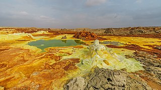
Dallol is a unique, terrestrial hydrothermal system around a cinder cone volcano in the Danakil Depression, northeast of the Erta Ale Range in Ethiopia. It is known for its unearthly colors and mineral patterns, and the very acidic fluids that discharge from its hydrothermal springs.

