
Lava lakes are large volumes of molten lava, usually basaltic, contained in a volcanic vent, crater, or broad depression. The term is used to describe both lava lakes that are wholly or partly molten and those that are solidified.
Borale Ale is a stratovolcano located in the Great Rift Valley, Ethiopia.
Hayli Gubbi is a shield volcano located in the Afar Region of Ethiopia. It is the southernmost volcano of the Erta Ale Range.

Erta Ale Range is the most important axial volcanic chain of the Afar Depression, Afar Region, Ethiopia. It consists mostly of shield volcanoes.

Ale Bagu is a stratovolcano located in the Afar Region, Ethiopia. It is the highest volcano of Erta Ale Range. The village of El Dom sits at the base of Ale Bagu.

Tat Ali is a low Holocene shield volcano located in the northern part of the Afar Region of Ethiopia. This elevation is characterized as having an elongated summit depression that has produced a variety of rock types, ranging from basalts to pantellerites. NNW-SSE-trending fissures cutting the volcano have fed basaltic lava flows; those NE of Lake Afrera are of prehistoric date. Late-stage volcanism produced youthful basaltic lava flows on the floor of the summit depression, which is also the site of prominent fumarolic activity.
Gada Ale is a stratovolcano located in the Afar Region, Ethiopia. It is the most prominent volcano at the northern end of the Erta Ale Range.

The Alid Volcano is a stratovolcano located in the Northern Red Sea region of Eritrea in the Danakil Depression. The peak elevation from its base is 904 metres (2,966 ft). The volcano's most recent activity was identified in 1928, when it emitted smoke. It is a large volcano located in the northern east coast.

Alu is a system of volcanic fissures, located in Ethiopia. The fissures have produced silicic lava flows, and other fissures south of the volcano have been the source of huge youthful basaltic lava flows, which enlarge to the north as far as Lake Bakili. There is major fumarolic activity, located on parallel faults, some with 100-m uplifts.

Afdera is an isolated stratovolcano in northeastern Ethiopia, located at the intersection of three fault systems between the Erta Ale, Tat Ali, and Alayta mountain ranges.
Erta Ale is a continuously active basaltic shield volcano in the Afar Region of northeastern Ethiopia, which is itself part of the wider Afar Triangle. Erta Ale is located in the Danakil Depression, an area below sea level between the last two countries, and is the most active volcano in Ethiopia.
Mount Alayta is an active shield volcano in the Afar Region of Ethiopia. It is part of the Afar Triangle, a highly active volcanic region which includes the adjacent Mount Afdera. Mount Alayta covers an area of 2,700 square kilometers southwest of Lake Afrera. A chain of younger craters are aligned along a north-northwest axis in the basaltic-to-trachytic shield along the east side of the shield volcano, which extends to the western flank of Mount Afdera. The Alayta Lavafeld was formed from a series of north-south fissures. In two areas on the southern side of the volcanic complex, fumaroles can be observed.

Sork Ale is a sicilic stratovolcano located in the Danakil Horst at the southern end of the Danakil Alps near the Ethiopia/Eritrea border. It makes up part of the Bidu volcanic complex.

Asavyo also known as Bara Ale is a large silicic stratovolcano in Ethiopia, which forms part of the Bidu Volcanic complex. It lies about 20 km southwest from the Nabro and Mallahle volcanoes. Asavyo has a 12 km wide caldera.
The Danakil Alps are a highland region in Ethiopia and Eritrea with peaks over 1000 metres in height and a width varying between 40 and 70 kilometres. The area is known in the Afar language as Arrata. The alps lie along the southern Red Sea to the east of the Danakil Depression and separate it from the sea. The alps are asymmetric in cross-section with a comparatively gentle rift escarpment facing the Red Sea and intense normal faulting on the inland side.
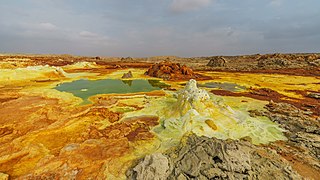
Dallol is a unique, terrestrial hydrothermal system around a cinder cone volcano in the Danakil Depression, northeast of the Erta Ale Range in Ethiopia. It is known for its unearthly colors and mineral patterns, and the very acidic fluids that discharge from its hydrothermal springs.
Ma Alalta is a stratovolcano in the Afar Region of Ethiopia, located well to the west of the Danakil Depression at the foot of the regional Ethiopian scarp. It has a summit elevation of 1,745 m (5,725 ft) and lies between two large horsts related to the East African Rift.

