
Boulder County is a county located in the U.S. state of Colorado of the United States. As of the 2020 census, the population was 330,758. The most populous municipality in the county and the county seat is Boulder.

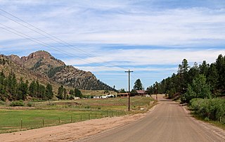
Allenspark is an unincorporated town, a post office, and a census-designated place (CDP) located in and governed by Boulder County, Colorado, United States. The CDP is a part of the Boulder, CO Metropolitan Statistical Area. The Allenspark post office has the ZIP code 80510. At the United States Census 2010, the population of the Allenspark CDP was 528, while the population of the 80510 ZIP Code Tabulation Area was 420.
Westcreek is an unincorporated community and a census-designated place (CDP) located in and governed by Douglas County, Colorado, United States. The CDP is a part of the Denver–Aurora–Lakewood, CO Metropolitan Statistical Area. The population of the Westcreek CDP was 129 at the United States Census 2010. The Sedalia post office serves the area.

Aspen Park is an unincorporated community and a census-designated place (CDP) located in Jefferson County, Colorado, United States. The CDP is a part of the Denver–Aurora–Lakewood, CO Metropolitan Statistical Area. The population of the Aspen Park CDP was 810 at the United States Census 2020. The Aspen Park Metropolitan District provides services. The Conifer post office serves the area.

St. Vrain Creek is a tributary of the South Platte River, approximately 32.2 miles (51.8 km) long, in north central Colorado in the United States. It drains part of the foothills north of Boulder and the Colorado Piedmont area in the vicinity of Longmont.
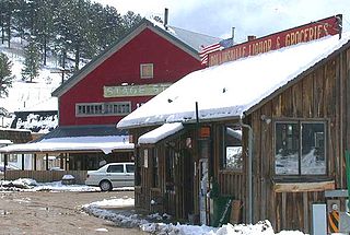
Rollinsville is a census-designated place (CDP) and post office in and governed by Gilpin County, Colorado, United States. The CDP is a part of the Denver–Aurora–Lakewood, CO Metropolitan Statistical Area. The Rollinsville post office has the ZIP Code 80474. At the United States Census 2010, the population of the Rollinsville CDP was 181.
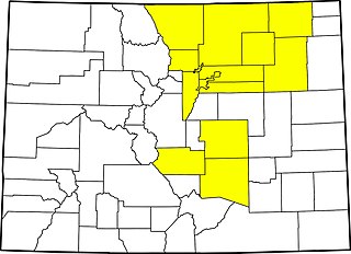
Colorado's 2nd congressional district is a congressional district in the U.S. state of Colorado. The district is located in the north-central part of the state and encompasses the northwestern suburbs of Denver including Boulder, Broomfield and much of western Jefferson County. The district also includes the mountain towns of Vail, Grand Lake and Idaho Springs. Redistricting in 2011 moved Larimer County, including the cities of Fort Collins and Loveland, to the 2nd from the 4th district for the 2012 election.

The North Central Colorado Urban Area comprises the four contiguous metropolitan statistical areas in the north central region of the State of Colorado: the Denver–Aurora Metropolitan Statistical Area, the Boulder Metropolitan Statistical Area, the Fort Collins-Loveland Metropolitan Statistical Area, and the Greeley Metropolitan Statistical Area. With the exception of southeastern Elbert County, southeastern Park County, and tiny portions of southern Douglas County, the entire North Central Colorado Urban Area is drained by the South Platte River and its tributaries. The North Central Colorado Urban Area is the central, and the most populous, of the three primary subregions of the Front Range Urban Corridor.

Boulder Creek is a 31.4-mile-long (50.5 km) creek draining the Rocky Mountains to the west of Boulder, Colorado, as well as the city itself and surrounding plains.

Eldorado Mountain is a mountain summit on the eastern flank of the Front Range of the Rocky Mountains of North America. The 8,344-foot (2,543 m) peak is located 8.1 miles (13.1 km) south by west of downtown Boulder, Colorado, United States. The mountain is largely in Boulder County but it straddles the border and its southern flanks are located in Jefferson County. Its name was probably borrowed from the nearby community of Eldorado Springs.

Altona is an unincorporated community and a census-designated place (CDP) located in and governed by Boulder County, Colorado, United States. The CDP is a part of the Boulder, CO Metropolitan Statistical Area. The population of the Altona CDP was 501 at the United States Census 2010. The Boulder post office serves the area.

Bark Ranch is an unincorporated community and a census-designated place (CDP) located in and governed by Boulder County, Colorado, United States. The Bark Ranch CDP encompasses the Bar-K Ranch housing community. The CDP is a part of the Boulder, CO Metropolitan Statistical Area. The population of the Bark Ranch CDP was 213 at the United States Census 2010. The Ward post office serves the area.

St. Ann Highlands is an unincorporated community and a census-designated place (CDP) located in and governed by Boulder County, Colorado, United States. The CDP is a part of the Boulder, CO Metropolitan Statistical Area. The population of the St. Ann Highlands CDP was 288 at the United States Census 2010. The Nederland post office serves the area.

Valmont is an unincorporated community and a census-designated place (CDP) located in and governed by Boulder County, Colorado, United States. The CDP is a part of the Boulder, CO Metropolitan Statistical Area. The population of the Valmont CDP was 59 at the United States Census 2010. The Boulder post office serves the area.

The Front Range Urban Corridor is an oblong region of urban population located along the eastern face of the Southern Rocky Mountains, encompassing 18 counties in the US states of Colorado and Wyoming. The corridor derives its name from the Front Range, the mountain range that defines the western boundary of the corridor which serves as a gateway to the Rocky Mountains. The region comprises the northern portion of the Southern Rocky Mountain Front geographic area, which in turn comprises the southern portion of the Rocky Mountain Front geographic area of Canada and the United States. The Front Range Urban Corridor had a population of 5,055,344 at the 2020 Census, an increase of +16.65% since the 2010 Census.
The 2013 Colorado floods were a series of natural disasters occurring in the U.S. state of Colorado. Starting on September 11, 2013, a slow-moving cold front stalled over Colorado, clashing with warm humid monsoonal air from the south. This resulted in heavy rain and catastrophic flooding along Colorado's Front Range from Colorado Springs north to Fort Collins. The situation intensified on September 11 and 12. Boulder County was worst hit, with 9.08 inches (231 mm) recorded September 12 and up to 17 inches (430 mm) of rain recorded by September 15, which is comparable to Boulder County's average annual precipitation. This event has also been referred to as the 2013 Colorado Front Range Flood, reflecting a more precise geographic extent in and along the Colorado Front Range mountains.
