
Parramatta is a major commercial suburb and centre in Greater Western Sydney, located in the state of New South Wales, Australia. It is located approximately 24 kilometres (15 mi) west of the Sydney central business district on the banks of the Parramatta River. Parramatta is the administrative seat of the local government area of the City of Parramatta and is often regarded as the main commercial centre and the central business district for the broader Greater Western Sydney region. Parramatta also has a long history as a second administrative centre in the Sydney metropolitan region, playing host to a number of state government departments as well as state and federal courts.

Rose Bay is a harbourside, eastern suburb of Sydney, in the state of New South Wales, Australia. Rose Bay is located seven kilometres east of the Sydney central business district, in the local government areas of Waverley Council and Municipality of Woollahra.

The Great Western Highway is a 201-kilometre-long (125 mi) state highway in New South Wales, Australia. From east to west, the highway links Sydney with Bathurst, on the state's Central Tablelands.
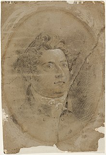
Francis Howard Greenway was an English-born architect who was transported to Australia as a convict for the crime of forgery. In New South Wales he worked for the Governor, Lachlan Macquarie, as Australia's first government architect. He became widely known and admired for his work displayed in buildings such as St Matthew's Church in Windsor, New South Wales, St James' Church, Sydney and Hyde Park Barracks, Sydney.

Centennial Park is a suburb split between the local government area of the City of Sydney and the City of Randwick, on Gadigal land in Eora country, located 4 kilometres (2.5 mi) south-east of the Sydney central business district, in the eastern suburbs of Sydney in the state of New South Wales, Australia.

Woollahra is a suburb in the Eastern Suburbs of Sydney, in the state of New South Wales, Australia. Woollahra is located 5 kilometres east of the Sydney central business district, in the local government area of the Municipality of Woollahra. Woollahra is located on the traditional land of the Birrabirragal and Gadigal people of the Eora Nation. The Municipality of Woollahra takes its name from the suburb but its administrative centre is located in Double Bay. Woollahra is famous for its quiet, tree-lined residential streets and village-style shopping centre.

Mulgoa is a village, located in the local government area of the City of Penrith, in the region of western Sydney, in the state of New South Wales, Australia. Mulgoa is located approximately 66 kilometres (41 mi) west of the Sydney central business district.

Castlereagh is a suburb of Sydney, in the state of New South Wales, Australia. Castlereagh is 67 kilometres (42 mi) north-west of the Sydney central business district, in the local government area of the City of Penrith and is part of the Greater Western Sydney region.

The City of Lithgow is a local government area in the Central West region of New South Wales, Australia. The area is located adjacent to the Great Western Highway and the Main Western railway line.
Bowenfels is a small town on the western outskirts of Lithgow, New South Wales, Australia.
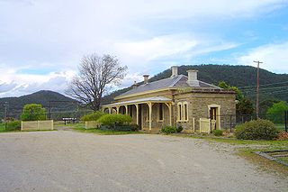
The Bowenfels railway station is a heritage-listed disused railway station and now visitor's centre and restaurant located on the Main Western line in Bowenfels, City of Lithgow, New South Wales, Australia. It was designed by John Clifton and the New South Wales Government Railways and built from 1869 to 1869 by G. Watsford, NSW Government Railway. It is also known as the Bowenfels Railway Station and Stationmaster's House and Old Station Masters Residence and Station. It was added to the New South Wales State Heritage Register on 2 April 1999.
Newcastle West is an inner city suburb of Newcastle, New South Wales, Australia, part of which forms the western end of Newcastle's central business district. The suburb is primarily a retail/commercial trading district but includes one high school.

Mosman is a suburb on the Lower North Shore region of Sydney, in the state of New South Wales, Australia. Mosman is located 8 kilometres north-east of the Sydney central business district and is the administrative centre for the local government area of the Municipality of Mosman.
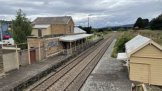
The Wallerawang railway station is a heritage-listed disused railway station located on the Main Western line in Wallerawang, City of Lithgow, New South Wales, Australia. It is also known as Wallerawang Railway Station and yard group. The property was added to the New South Wales State Heritage Register on 2 April 1999.

The Lithgow Heavy Anti Aircraft Gun Stations and Dummy Station is a heritage-listed former gun emplacements, anti aircraft gun batteries and dummy batteries and now disused railway signal box located via Kirkley Street, Bowenfels, City of Lithgow, New South Wales, Australia. It was built from 1941 to 1942 by Water Conservation & Irrigation Commission, Defence. It is also known as Lithgow Anti Aircraft Gun Emplacements and Heavy Anti Aircraft guns 3.7 inch anti aircraft guns. The property is owned by Lithgow City Council. It was added to the New South Wales State Heritage Register on 5 August 2011.

The Marrangaroo railway viaduct is a heritage-listed railway viaduct that carries the Main Western line across Marrangaroo Creek at Marrangaroo in the City of Lithgow local government area of New South Wales, Australia. The property added to the New South Wales State Heritage Register on 2 April 1999.

The McKanes Falls Bridge is a heritage-listed road bridge at McKanes Falls Road, South Bowenfels, New South Wales, Australia. It was designed by John McDonald and NSW Engineer for Bridges and built from 1892 to 1893 by NSW Public Works. It is also known as McKanes Bridge. The property is owned by Transport for NSW. It was added to the New South Wales State Heritage Register on 20 June 2000.

The Bowenfels rail viaducts are a series of heritage-listed railway viaducts and railway bridges over Farmers Creek on the Main Western line in Bowenfels, City of Lithgow, New South Wales, Australia. It was designed in two stages, by John Whitton as the Engineer-in-Chief for Railways, in 1870; and by engineering staff of New South Wales Government Railways in 1921; and was built from 1870 to 1921. It is also known as Farmers Creek viaducts. The property is owned by RailCorp, an agency of the Government of New South Wales. It was added to the New South Wales State Heritage Register on 2 April 1999. The viaduct are located approximately 159 kilometres (99 mi) west of Central railway station.

The Coxs River railway bridges are two heritage-listed railway bridges that carry the Main Western line over the Coxs River at Wallerawang, City of Lithgow, New South Wales, Australia. The bridges were designed by engineering staff of the New South Wales Government Railways and built in 1870 by day labour. The property is owned by RailCorp, an agency of the Government of New South Wales. It was added to the New South Wales State Heritage Register on 2 April 1999.

The Bowenfels National School Site is a heritage-listed former artist's studio and school and now residence located at 70 Mudgee Street, South Bowenfels, City of Lithgow, New South Wales, Australia. It was built from 1851 to 1853 by James Connor, a mason. It was added to the New South Wales State Heritage Register on 2 April 1999.
