South Haven Charter Township, Michigan

Last updated
South Haven Charter Township, Michigan
USA Michigan location map.svg
Red pog.svg
South Haven Charter Township, Michigan
Location within the state of Michigan
Coordinates: 42°22′24″N86°15′57″W / 42.37333°N 86.26583°W / 42.37333; -86.26583
Country United States
State Michigan
County Van Buren
Area
  Total17.5 sq mi (45.4 km2)
  Land17.5 sq mi (45.4 km2)
  Water0.0 sq mi (0.0 km2)
Elevation
640 ft (195 m)
Population
 (2000)
  Total4,046
  Density230.7/sq mi (89.1/km2)
Time zone UTC-5 (Eastern (EST))
  Summer (DST) UTC-4 (EDT)
ZIP code
49090
Area code 269
FIPS code 26-75000 [1]
GNIS feature ID1627099 [2]
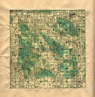
A 1906 cadastral map of South Haven Township, showing property lines and names of rural landowners Van Buren County Michigan 1906 South Haven Township.jpg
A 1906 cadastral map of South Haven Township, showing property lines and names of rural landowners

South Haven Charter Township is a charter township of Van Buren County in the U.S. state of Michigan. The population was 4,046 at the 2000 census. The city of South Haven is located to the northwest of the township.[ citation needed ]

Contents

The city of South Haven has annexed portions of land that was once within the township boundaries, but is administratively autonomous. There are no other incorporated municipalities within the township. The area south of South Haven is considered to be a part of the city's urban area. Other settlements are in the unincorporated communities:

Geography

The northern portion of the township is drained by the Black River, which has its mouth at South Haven. The southern portion is drained by Deerlick Creek and other unnamed creeks.[ citation needed ]

Interstate 196/U.S. Highway 31 (I-196/US 31) runs mostly north–south through the township, roughly parallel with the Lake Michigan shore and skirting the east side of South Haven. M-140 runs due north–south through the township into South Haven. M-43 runs southeast–northwest through Maple Grove Corners into South Haven.[ citation needed ]

According to the United States Census Bureau, the township has a total area of 17.5 square miles (45.4 km2), all land.[ citation needed ]

Demographics

As of the census [1] of 2000, there were 4,046 people, 1,645 households, and 1,092 families residing in the township. The population density was 230.7 inhabitants per square mile (89.1/km2). There were 1,890 housing units at an average density of 107.8 per square mile (41.6/km2). The racial makeup of the township was 82.11% White, 12.61% African American, 0.72% Native American, 0.42% Asian, 1.93% from other races, and 2.22% from two or more races. Hispanic or Latino of any race were 5.34% of the population.

There were 1,645 households, out of which 31.4% had children under the age of 18 living with them, 48.8% were married couples living together, 13.4% had a female householder with no husband present, and 33.6% were non-families. 28.9% of all households were made up of individuals, and 11.8% had someone living alone who was 65 years of age or older. The average household size was 2.43 and the average family size was 2.97.[ citation needed ]

In the township the population was spread out, with 27.2% under the age of 18, 7.5% from 18 to 24, 26.9% from 25 to 44, 24.1% from 45 to 64, and 14.3% who were 65 years of age or older. The median age was 38 years. For every 100 females, there were 92.5 males. For every 100 females age 18 and over, there were 86.9 males.[ citation needed ]

The median income for a household in the township was $35,000, and the median income for a family was $38,922. Males had a median income of $31,754 versus $22,363 for females. The per capita income for the township was $17,097. About 9.1% of families and 11.8% of the population were below the poverty line, including 18.0% of those under age 18 and 10.2% of those age 65 or over.

Related Research Articles

<span class="mw-page-title-main">Van Buren County, Michigan</span> County in Michigan, United States

Van Buren County is a county located in the U.S. state of Michigan. As of the 2020 Census, the population was 75,587. The county seat is Paw Paw. The county was founded in 1829 and organized in 1837.

Casco Township is a civil township of Allegan County in the U.S. state of Michigan. The population was 2,823 at the 2010 census.

Lee Township is a civil township of Allegan County in the U.S. state of Michigan. The population was 4,015 at the 2010 census.

<span class="mw-page-title-main">Lake Charter Township, Michigan</span> Charter township in Michigan, United States

Lake Charter Township is a charter township of Berrien County in the U.S. state of Michigan. The population was 2,972 at the 2010 census.

<span class="mw-page-title-main">Oronoko Charter Township, Michigan</span> Charter township in Michigan, United States

Oronoko Charter Township is a charter township of Berrien County in the U.S. state of Michigan. The population was 9,193 at the 2010 census.

<span class="mw-page-title-main">Pipestone Township, Michigan</span> Civil township in Michigan, United States

Pipestone Township is a civil township of Berrien County in the U.S. state of Michigan. The population was 2,312 at the 2010 census. The township was organized on February 16, 1842.

<span class="mw-page-title-main">Royalton Township, Michigan</span> Civil township in Michigan, United States

Royalton Township is a civil township of Berrien County in the U.S. state of Michigan, a few miles southeast of the city of St. Joseph. The population was 4,766 at the 2010 census, up from 3,888 at the 2000 census. There are no incorporated municipalities in the township, but portions are considered to be part of the Benton Harbor/St. Joseph urban area. The unincorporated communities of Hollywood, Scottdale, Arden, and Buckhorn are within the township.

<span class="mw-page-title-main">Oshtemo Township, Michigan</span> Charter township in Michigan, United States

Oshtemo Charter Township is a charter township of Kalamazoo County in the U.S. state of Michigan. The 2010 census recorded a population of 21,705, up from 17,003 at the 2000 census. The township was organized in 1839.

Filer Charter Township is a charter township of Manistee County in the U.S. state of Michigan. The population was 2,318 at the 2020 census.

<span class="mw-page-title-main">Fruitport, Michigan</span> Village in Michigan, United States

Fruitport is a village in Muskegon County in the U.S. state of Michigan. The population was 1,103 at the 2020 census. The community is located within Fruitport Charter Township.

Grand Haven Charter Township is a charter township of Ottawa County in the U.S. state of Michigan. The population was 15,178 at the 2010 census. The Grand Haven Township is located immediately south of Grand Haven.

Robinson Township is a civil township of Ottawa County in the U.S. state of Michigan. The population was 5,588 at the 2000 census.

<span class="mw-page-title-main">Columbia Township, Van Buren County, Michigan</span> Township in Michigan, United States

Columbia Township is a civil township of Van Buren County in the U.S. state of Michigan. The population was 2,714 at the 2000 census, down to 2,588 at the 2010 census.

Covert Township is a civil township of Van Buren County in the U.S. state of Michigan. As of the 2010 United States Census, the population was 2,888.
<span class="mw-page-title-main">Geneva Township, Van Buren County, Michigan</span> Township in Michigan, United States

Geneva Township is a civil township of Van Buren County in the U.S. state of Michigan. The population was 3,975 at the 2000 United States Census.

<span class="mw-page-title-main">Pine Grove Township, Michigan</span> Township in Michigan, United States

Pine Grove Township is a civil township of Van Buren County in the U.S. state of Michigan. The population was 2,773 at the 2000 census.

<span class="mw-page-title-main">Huron Charter Township, Michigan</span> Charter township in Michigan, United States

Huron Charter Township is a charter township of Wayne County in the U.S. state of Michigan. The population was 15,879 at the 2010 census. Huron Charter Township is named after the Huron River, which flows southeast through the township. The township is home to three divisions of the Huron–Clinton Metroparks system: Lower Huron, Oakwoods, and Willow.

<span class="mw-page-title-main">Van Buren Township, Michigan</span> American township in Michigan

Van Buren Township is a charter township in Wayne County in the U.S. state of Michigan. A western suburb of Detroit, Van Buren Township is located roughly 28 miles (45.1 km) southwest of downtown Detroit, and 17 miles (27.4 km) southeast of Ann Arbor. As of the 2020 census, the township had a population of 30,375. It surrounds, but is independent of, the city of Belleville.

Crockery Township is a civil township of Ottawa County in the U.S. state of Michigan. As of the 2010 census, the township population was 3,960.

<span class="mw-page-title-main">South Haven, Michigan</span> City in Michigan, United States

South Haven is a city in the U.S. state of Michigan. Most of the city is in Van Buren County, although a small portion extends into Allegan County. The population was 3,964 at the 2020 census.

References

  1. 1 2 "U.S. Census website". United States Census Bureau . Retrieved 2008-01-31.
  2. U.S. Geological Survey Geographic Names Information System: South Haven Charter Township, Michigan