South Kuta

Last updated
South Kuta
Kuta Selatan
Indonesia Badung South Kuta district location map.svg
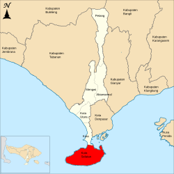
Location of South Kuta District within Badung Regency
Country Indonesia
Region Lesser Sunda Islands
Province Bali
Regency Badung
Area
  Total101.13 km2 (39.05 sq mi)
Population
 (2020)
  Total131,139
  Density1,300/km2 (3,400/sq mi)
Website kutaselatan.badungkab.go.id

South Kuta (Indonesian: Kuta Selatan) is a district (kecamatan) within Badung Regency of Bali. It consists of Nusa Dua, a large peninsula projecting south from Bali island.

It covers 101.13 km2 and had a population of 116,143 people as of the 2010 Census [1] and 131,139 at the 2020 Census. [2]

It includes six villages, listed below with their areas and their populations at the 2010 Census [3] and 2020 Census. [4]

NameArea
in
km2
Pop'n
2010
Census
Pop'n
2020
Census
Pecatu 26.417,37813,713
Ungasan 14.9914,22116,716
Kutuh 8.563,6065,322
Benoa 28.2839,57041,722
Tanjung Benoa 2.396,7676,376
Jimbaran 20.5044,37647,290
Totals101.13115,918131,139

Jimbaran lies at the southern end of the isthmus connecting the Nusa Dua (or Bukit Badung) peninsula - a harsh, scrubby limestone plateau off the south side of Bali - with Kuta and Tuban further north. Pecatu, Ungasan and Kutuh are villages high up on the plateau, while Benoa lies at the eastern end of the peninsula and contains the resort area of Nusa Dua, with Tanjung Benoa forming a narrow sandbar extending north towards Denpasar.

Related Research Articles

<span class="mw-page-title-main">Saparua</span> Island in Maluku, Indonesia

Saparua is an island east of Ambon Island in the Indonesian province of Maluku; the island of Haruku lies between Saparua and Ambon. The main port is in the south at Kota Saparua. The small and uninhabited island of Maolana is located near its southwestern side and Nusa Laut off its southeastern tip.

<span class="mw-page-title-main">Denpasar</span> City and capital of Bali, Indonesia

Denpasar is the capital city of the province of Bali, Indonesia. Denpasar is the main gateway to the Bali island, the city is also a hub for other cities in the Lesser Sunda Islands.

<span class="mw-page-title-main">Kangean Islands</span> Place

The Kangean Islands or simply Kangean is a collective name for a group of islands lying to the east of Madura. Kangean and its surrounding islands lie to the north of Bali in the northern Bali Sea, to the northwest of the Lesser Sunda Islands, and administratively they form three districts within Sumenep Regency, East Java Province. The group comprises a total of 91 islands including 27 inhabited islands. Kangean is located approximately 120 km (75 mi) in the north of Bali, the northwest of Lombok, and 120 km east of Madura. The biggest and most populous district is Arjasa, which includes the town of that name located in the west of the island. The Kangean Islands have a large potential for natural resources, such as natural gas, teak, coconut, and salt production.

<span class="mw-page-title-main">Ende Regency</span> Regency in East Nusa Tenggara, Indonesia

Ende Regency is a regency on the island of Flores, within East Nusa Tenggara Province of Indonesia. The capital is the town of Ende, on the south coast of the Regency. The regency covers an area of 2,085.19 km2, and it had a population of 260,605 at the 2010 Census and 270,763 at the 2020 Census; the official estimate as at mid 2023 was 278,581. It is bordered to the west by Nagekeo Regency and to the east by Sikka Regency, while the Flores Sea lies to the north and the Savu Sea to the south.

<span class="mw-page-title-main">Klungkung Regency</span> Regency of Indonesia

Klungkung Regency is the smallest regency (kabupaten) in the island province of Bali, Indonesia. It has an area of 315 km2 and had a population at the 2010 Census of 170,543 which increased to 206,925 at the Census of 2020; the official estimate as at mid 2022 was 214,012. The administrative centre for the regency is in the town of Semarapura.

<span class="mw-page-title-main">Bangli Regency</span> Regency in Bali, Indonesia

Bangli Regency is the one and only landlocked regency (kabupaten) of Bali, Indonesia.

<span class="mw-page-title-main">Mandailing Natal Regency</span> Regency in North Sumatra, Indonesia

Mandailing Natal, a.k.a. Madina, is a regency in North Sumatra Province of Indonesia. It covers an area of 6,620.70 square kilometres and it had a population of 403,894 people at the 2010 census and 472,886 at the 2020 Census; the official estimate as at mid 2023 was 496,975. The capital lies at Panyabungan. The Regency was formerly a part of South Tapanuli Regency until it was created as a separate regency on 23 November 1998. It is the southernmost regency in North Sumatra, and the largest regency by land area in the province, with Langkat Regency second to it.

<span class="mw-page-title-main">Kuta District</span> District in Lesser Sunda Islands, Indonesia

Kuta District is a district within Badung Regency of Bali, Indonesia. It is Bali and Indonesia's most internationally oriented and touristic district, home to the world famous Kuta Beach and the fishing village Jimbaran.

<span class="mw-page-title-main">Central Lombok Regency</span> Regency in West Nusa Tenggara, Indonesia

Central Lombok Regency is a regency of the Indonesian Province of West Nusa Tenggara. It is located on the island of Lombok and the capital is Praya. It covers an area of 1,208.39 km2, and had a population of 859,309 at the 2010 census and 1,034,859 at the 2020 census; the official estimate as at mid 2023 was 1,099,211.

<span class="mw-page-title-main">Dompu Regency</span> Regency in West Nusa Tenggara, Indonesia

Dompu Regency is a regency of the Indonesian Province of West Nusa Tenggara. It is located on the island of Sumbawa and the capital is Dompu. It is bordered to the north and to the east by two non-contiguous parts of Bima Regency, and to the west by Sumbawa Regency, as well as on its coasts by Saleh Bay, Sanggar Bay, and Cempi Bay. It covers an area of 2,324.55 km2, and the population at the 2010 Census was 218,984 and at the 2020 Census was 236,665; the official estimate as at mid 2023 was 247,188.

<span class="mw-page-title-main">Sumbawa Regency</span> Regency in West Nusa Tenggara, Indonesia

Sumbawa Regency is a Regency (Kabupaten) of the Indonesian Province of West Nusa Tenggara. It is located on the island of Sumbawa and covers an area of 6,643.99 km2, following the separation on 18 December 2003 of what were until then its westernmost five districts to form the newly created West Sumbawa Regency. It includes the substantial island of Moyo, lying off the north coast of Sumbawa. The population of the Regency at the 2010 Census was 415,789, which rose at the 2020 Census to 509,753; the official estimate as at mid 2023 was 529,487. The capital is the town of Sumbawa Besar on the north coast of Sumbawa Island.

<span class="mw-page-title-main">West Sumbawa Regency</span> Regency in West Nusa Tenggara, Indonesia

West Sumbawa Regency is a Regency (Kabupaten) of the Indonesian Province of West Nusa Tenggara. It is located on the island of Sumbawa and has an area of 1,743.58 km2. The regency was created on 18 December 2003 from what were at that time the westernmost five districts (kecamatan) of Sumbawa Regency. The population at the 2010 Census was 114,754, and at the 2020 Census was 145,798; the official estimate as at mid 2023 was 152,950 comprising 77,030 males and 75,920 females. The capital is the town of Taliwang.

<span class="mw-page-title-main">East Flores Regency</span> Regency in East Nusa Tenggara, Indonesia

East Flores Regency is a regency in East Nusa Tenggara province of Indonesia. Established in 1958, the regency has its seat (capital) in Larantuka on Flores Island. It covers a land area of 1,812.58 km2, and it had a population of 232,605 as of the 2010 census and 276,896 at the 2020 Census; the official estimate as of mid-2023 was 288,310 - comprising 141,738 males and 146,572 females. The regency encompasses the eastern tip of the island of Flores, together with all of the adjacent islands of Adonara and Solor to the east of Flores, with some much smaller offshore islands. On 4 October 1999, the island of Lembata at the eastern end of the Solor Archipelago was separated from the East Flores Regency to create its own Regency.

<span class="mw-page-title-main">Manggarai Regency</span> Regency in East Nusa Tenggara, Indonesia

Manggarai Regency is a regency in East Nusa Tenggara province of Indonesia, situated on the island of Flores. Established in 1958 the regency was reduced in size and population by the separation of the more western districts to form West Manggarai Regency in 2003 and of the more eastern districts to form East Manggarai Regency in 2007. The area of the residual Manggarai Regency is 1,343.83 km2 and its population was 292,037 at the 2010 census and 312,855 at the 2020 census; the official estimate as at mid 2023 was 328,758. The capital of the regency is the town of Ruteng.

<span class="mw-page-title-main">Kupang Regency</span> Regency in Lesser Sunda Islands, Indonesia

Kupang Regency is a regency in East Nusa Tenggara province of Indonesia. It occupies the far western end of Timor Island, together with the smaller island of Semau and other minor offshore islands. Other islands further to the southwest and west which were formerly part of Kupang Regency have been separated administratively - the Rote Islands Group on 10 April 2002, and the Savu Islands on 29 October 2008.

West Halmahera Regency is a regency in North Maluku Province of Indonesia. The regency was created on 25 February 2003 from the western districts of the former North Maluku Regency, and is now bounded by North Halmahera Regency to the north and east, while to the south it borders both East Halmahera Regency and that portion of the city of Tidore on the mainland of Halmahera. It covers an area of 2,239.11 km2, and it had a population of 100,424 people at the 2010 Census and 132,349 at the 2020 Census; the official estimate as at mid 2023 was 137,543. The capital lies at Jailolo (town).

<span class="mw-page-title-main">Badung Regency</span> Regency of Indonesia

Badung is a regency of Bali, Indonesia. Its regency seat is in the upland town of Mangupura. It covers districts to the west of the provincial capital of Denpasar, and it has a land area of 418.52 km2.

<span class="mw-page-title-main">North Kuta</span> District in Badung Regency, Bali Province, Indonesia

North Kuta, is a district in Badung Regency of Bali, Indonesia.

<span class="mw-page-title-main">Mengwi</span> District in Badung Regency, Bali Province, Indonesia

Mengwi is a district (kecamatan) in the Badung Regency, Bali, Indonesia and also covers Bali's heaviest tourist regions, situated to the north of Kuta District and North Kuta District, and including Canggu. It covers an area of 82.0 km2 and had a population of 122,829 at the 2010 Census and 132,786 at the 2020 Census.

<span class="mw-page-title-main">Denpasar metropolitan area</span> Place in Bali, Indonesia

Denpasar metropolitan area or officially Sarbagita; is a metropolitan area located in Indonesia. This area includes Denpasar city and its surrounding areas such as Badung Regency, Gianyar Regency, and Tabanan Regency. This region of Bali province. Sarbagita is the largest metropolitan area in the Nusa Tenggara Islands and the second largest in the Eastern Indonesia Region after the Makassar metropolitan area in South Sulawesi. It has an area of 1,928.28 km2, and at the 2023 estimate had a population of 2,301,887

References

  1. Biro Pusat Statistik, Jakarta, 2011.
  2. Badan Pusat Statistik, Jakarta, 2021.
  3. Biro Pusat Statistik, Jakarta, 2011.
  4. Badan Pusat Statistik, Jakarta, 2021,