South Pennines Regional Park

Last updated

South Pennines Regional Park
Pennine scenery.jpg
South Pennines Regional Park
Coordinates 53°44′24″N2°03′29″W / 53.740°N 2.058°W / 53.740; -2.058
Area460 square miles (1,200 km2)
Elevation1,873 feet (571 m)
Created2021
Website Official website

The South Pennines Regional Park (or South Pennines Park) was a proposed national park that would cover the South Pennines area in Northern England, encompassing parts of Greater Manchester, Lancashire and West Yorkshire. It would also adjoin the borders of two existing national parks; the Yorkshire Dales in the north and the Peak District in the south. The area was named as a prospective national park in the 1940s when the idea of creating national parks was being carried forward, but it was never given the same status as the Peak District, North York Moors or the Yorkshire Dales.

Contents

The South Pennines Regional Park was championed by many agencies and charities. Pennine Prospects were awarded Heritage Lottery Funding in 2018. In September 2021, the park was launched under a "self-declaration" scheme, though its status is not recognised by DEFRA.

The organisation behind the proposal closed at the end of 2023. [1] The South Pennines is the only upland area of England without any designated protection framework.

History

In 1947, Sir Arthur Hobhouse delivered a report to the UK Government on the establishment of National Parks and Areas of Outstanding Natural Beauty (AONB). This in turn led to the passing of the National Parks and Access to the Countryside Act of 1949. [2] The creation of the parks and AONBs was seen as a "recreational gift to Britain’s returning Second World War service men and women". [3] By 2018, Britain had 15 National Parks and England had 34 AONBs; ten of the National parks are in England, Wales has three and Scotland has two. [note 1] [4] In the original list drawn up by Hobhouse, but not published, was the area of the South Pennines. However, it was decided that due to the industrial heritage of the region, it would not be appropriate to list the site for protection under either National Park status or as an AONB. [5]

In May 2018, the Environment Secretary, Michael Gove, announced a review into the National Parks. Writing in The Telegraph , Gove stated that the intent was to review their function but not to "diminish the protection of natural areas, but to strengthen it in the face of present-day challenges." This could lead to new national parks or certain AONBs being upgraded in their status. [6] [7] [8]

The South Pennines is a large upland area that extends from East Lancashire across West Yorkshire and touches Greater Manchester and the Peak District in the south. [9] The region is the only upland area in England without national park status or designated protected framework although various individual sections have some protected status (such as the South Pennine Moors Special Area of Conservation (SAC) which covers more than 65,000 hectares (160,000 acres) and describes moorland which has 9,000 year-old peatlands). [10] The South Pennines has 15 Sites of Special Scientific Interest (SSSIs) and 2,604 miles (4,190 km) of paths and bridleways including two national trails (the Pennine Way and the Pennine Bridleway). [11] After the announcement by Michael Gove, Pennine Prospects, [note 2] [12] a rural regeneration agency, urged the committee overseeing the National Parks review to not forget the South Pennines. [13] Pennine Prospects achieved Local Nature Partnership (LNP) status in 2012; the boundary of the LNP will mirror that of the National Character Area profile designated as the South Pennines. [14]

In 2018, Pennine Prospects was awarded Heritage Lottery Funding (HLF) for training and providing information in the designation of a Regional Park, the first of its kind in the country. Pennine Prospects stated before the National Parks review that rather than wait for government approval in a designated status, they would work from the ground up to achieve regional park status. [15] As part of this process, the park was announced in September 2021, under a "self-declaration" scheme, though without official recognition from the Department for the Environment and Rural Affairs (DEFRA). The self-designation scheme would see the park adjoin the borders of the Peak District National Park in the south, and the Yorkshire Dales National Park in the north. [16] The highest point is in the park is 1,873 feet (571 m), [17] and it covers an area of 460 square miles (1,200 km2). The population living inside that area of 660,000; more than twice the resident population of all of England's national parks combined. The park is also accessible within 30 minutes to 8 million people. [18] According to the chief executive of the park, it has 53 railway stations and four motorways within its boundaries. [19]

The organisation behind the proposal closed at the end of 2023. [1]

Settlements

According to Pennine Prospects and the National Character Area No. 36, the South Pennines Regional Park would encompass the following villages, towns and areas. [9] [11] [20] [note 3]

Rossendale Way Footpath Rossendale Way Footpath - geograph.org.uk - 1075652.jpg
Rossendale Way Footpath
M62 westbound, with Booth Wood Reservoir, and the summit of the M62 in the distance M62 westbound (3507874395).jpg
M62 westbound, with Booth Wood Reservoir, and the summit of the M62 in the distance

Lancashire

Greater Manchester

West Yorkshire

North Yorkshire

Notes

  1. There is a movement to create Britains' first Marine park off the coast of the Isle of Harris in the Outer Hebrides.
  2. Pennine Prospects was set up in 2005 to promote the South Pennines area and brings together six local authorities (Bradford, Calderdale, Kirklees, Lancashire, Oldham and Rochdale) with other interested stakeholders (Natural England, Historic England and the National Trust) and the major landowners (United Utilities and Yorkshire Water).
  3. The final boundaries are undecided at the moment and so this list is not exhaustive and some places on the list may not end up in the park if it is created.

Related Research Articles

<span class="mw-page-title-main">South Yorkshire</span> County of England

South Yorkshire is a ceremonial county in the Yorkshire and the Humber region of England. It borders North Yorkshire and West Yorkshire to the north, the East Riding of Yorkshire to the north-east, Lincolnshire to the east, Nottinghamshire to the south-east, and Derbyshire to the south and west. The largest settlement is the city of Sheffield.

<span class="mw-page-title-main">Area of Outstanding Natural Beauty</span> Designated area of countryside in England, Wales, and Northern Ireland

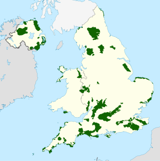
An Area of Outstanding Natural Beauty is one of 46 areas of countryside in England, Wales, or Northern Ireland that has been designated for conservation due to its significant landscape value. On 22 November 2023 the AONBs in England and Wales adopted a new name, National Landscapes, and are in the process of rebranding.

<span class="mw-page-title-main">North Yorkshire</span> County of England

North Yorkshire is a ceremonial county in the Yorkshire and the Humber and North East regions of England. It borders County Durham to the north, the North Sea to the east, the East Riding of Yorkshire to the south-east, South Yorkshire to the south, West Yorkshire to the south-west, and Cumbria and Lancashire to the west. Northallerton is the county town.

<span class="mw-page-title-main">West Yorkshire</span> County of England

West Yorkshire is a metropolitan and ceremonial county in the Yorkshire and the Humber region of England. It borders North Yorkshire to the north and east, South Yorkshire and Derbyshire to the south, Greater Manchester to the south-west, and Lancashire to the west. The city of Leeds is the largest settlement.

<span class="mw-page-title-main">Pennines</span> Range of uplands in Northern England

The Pennines, also known as the Pennine Chain or Pennine Hills, are a range of uplands mainly located in Northern England. Commonly described as the "backbone of England" because of its length and position, the range runs from the north Midlands to North East England, near the Anglo-Scottish border. The range starts near the valley of the River Trent to the south and extends northwards across the Peak District, South Pennines, Yorkshire Dales, and North Pennines, ending at the Tyne Gap. Beyond the gap are the Border Moors and Cheviot Hills, which are included in some definitions of the range.

<span class="mw-page-title-main">Yorkshire Dales</span> Upland area of the Pennines in Northern England

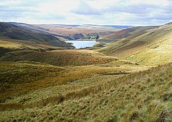
The Yorkshire Dales are an upland area of the Pennines in England. Most of the area is in the county of North Yorkshire, but it extends into Cumbria and a small part of Lancashire. It was historically entirely within Yorkshire. The majority of the Dales are part of the Yorkshire Dales National Park, created in 1954. The exception is the area around Nidderdale, which forms the separate Nidderdale Area of Outstanding Natural Beauty.

<span class="mw-page-title-main">Forest of Bowland</span> Upland conservation area in Lancashire, England

The Forest of Bowland, also known as the Bowland Fells and formerly the Chase of Bowland, is an area of gritstone fells, deep valleys and peat moorland, mostly in north-east Lancashire, England, with a small part in North Yorkshire. It is a western outlier of the Pennines.

<span class="mw-page-title-main">Dark Peak</span>

The Dark Peak is the higher and wilder part of the Peak District in England, mostly forming the northern section but also extending south into its eastern and western margins. It is mainly in Derbyshire but parts are in Staffordshire, Cheshire, Greater Manchester, West Yorkshire and South Yorkshire.

<span class="mw-page-title-main">North Pennines</span> Range of hills in northern England

The North Pennines is the northernmost section of the Pennine range of hills which runs north–south through northern England. It lies between Carlisle to the west and Darlington to the east. It is bounded to the north by the Tyne Valley and to the south by the Stainmore Gap.

<span class="mw-page-title-main">Brimham Rocks</span> Site of Special Scientific Interest in North Yorkshire, England

Brimham Rocks, once known as Brimham Crags, is a 183.9-hectare (454-acre) biological Site of Special Scientific Interest (SSSI) and Geological Conservation Review (GCR) site, 8 miles (13 km) north-west of Harrogate, North Yorkshire, England, on Brimham Moor in the Nidderdale Area of Outstanding Natural Beauty. The site, notified as SSSI in 1958, is an outcrop of Millstone Grit, with small areas of birch woodland and a large area of wet and dry heath.

<span class="mw-page-title-main">Teesdale</span> Valley in Northern England

Teesdale is a dale, or valley, in Northern England. The dale is in the River Tees's drainage basin; most water flows stem from or converge into said river, including the Skerne and Leven.

<span class="mw-page-title-main">Geography of England</span> Geographical features of England

England comprises most of the central and southern two-thirds of the island of Great Britain, in addition to a number of small islands of which the largest is the Isle of Wight. England is bordered to the north by Scotland and to the west by Wales. It is closer to continental Europe than any other part of mainland Britain, divided from France only by a 33 km (21 mi) sea gap, the English Channel. The 50 km (31 mi) Channel Tunnel, near Folkestone, directly links England to mainland Europe. The English/French border is halfway along the tunnel.

<span class="mw-page-title-main">Shropshire Hills</span> Upland area in Shropshire, West Midlands

The Shropshire Hills are a dissected upland area and one of the natural regions of England. They lie wholly within the county of Shropshire and encompass several distinctive and well-known landmarks, such as the Long Mynd, Wenlock Edge, The Wrekin and the Clees.

<span class="mw-page-title-main">Mountains and hills of England</span>

The mountains and hills of England comprise very different kinds of terrain, from a mountain range which reaches almost 1,000 metres high, to several smaller areas of lower mountains, foothills and sea cliffs. Most of the major upland areas have been designated as Areas of Outstanding Natural Beauty (AONB) or national parks. The highest and most extensive areas are in the north and west, while the midlands, south-east and east of the country tend to be low-lying.

<span class="mw-page-title-main">South Pennines</span> Region of moorland and hills in northern England

The South Pennines is a region of moorland and hill country in northern England lying towards the southern end of the Pennines. In the west it includes the Rossendale Valley and the West Pennine Moors. It is bounded by the Greater Manchester conurbation in the west and the Bowland Fells and Yorkshire Dales to the north. To the east it is fringed by the towns of West Yorkshire whilst to the south it is bounded by the Peak District. The rural South Pennine Moors constitutes both a Site of Special Scientific Interest and Special Area of Conservation.

<span class="mw-page-title-main">Horton, Lancashire</span> Village in Lancashire, England

Horton, historically known as Horton-in-Craven, is a village and a civil parish in the Ribble Valley district of the English county of Lancashire. Population details are now included in the civil parish of Newsholme. It is near the town of Barnoldswick. Horton has a place of worship, anciently called a chapelry or chapel of ease. For transport, there is the A59 nearby.

The Natural Areas of England are regions, officially designated by Natural England, each with a characteristic association of wildlife and natural features. More formally, they are defined as "biogeographic zones which reflect the geological foundation, the natural systems and processes and the wildlife in different parts of England...".

A National Character Area (NCA) is a natural subdivision of England based on a combination of landscape, biodiversity, geodiversity and economic activity. There are 159 National Character Areas and they follow natural, rather than administrative, boundaries. They are defined by Natural England, the UK government's advisors on the natural environment.

<span class="mw-page-title-main">Cow Myers (wetland)</span> Site of Special Scientific Interest in North Yorkshire, England

Cow Myers is a Site of Special Scientific Interest (SSSI) located in the Nidderdale Area of Outstanding Natural Beauty (AONB), near Ripon, North Yorkshire, England. The site was designated in 1984 for its fen and alder carr habitat, which supports a diversity of wetland plant life. Of particular interest are the bird's eye primrose which is scarce in Yorkshire, and early marsh orchid. There is no public access to this site, no vehicular access, and no public facilities.

<span class="mw-page-title-main">Hack Fall Wood</span> Site of Special Scientific Interest in North Yorkshire, England

Hack Fall Wood, otherwise known as Hackfall, is a Site of Special Scientific Interest, or SSSI, of 44.8687 hectares, lying north-east of the village of Grewelthorpe, North Yorkshire, England. During the 18th century it was landscaped in the picturesque style by landowner William Aislabie, who created views by engineering streams and pools, planting trees and building follies. J. M. W. Turner and William Sawrey Gilpin painted it, and pictures of it featured on Catherine the Great's 1773 Wedgwood dinner service. Some 19th century writers called it "one of the most beautiful woods in the country."

References

  1. 1 2 "Organisation behind The South Pennines Park to close". 2024. Retrieved 15 January 2024.
  2. "National Parks review launched". gov.uk. 27 May 2018. Retrieved 31 August 2018.
  3. Stubley, Peter (26 May 2018). "New national parks could be created as Michael Gove launches review of England's natural landscape" . The Independent. Archived from the original on 24 May 2022. Retrieved 31 August 2018.
  4. Milmo, Cahal (2 April 2009). "The Big Question: What are national parks, and why do we have so many" . The Independent. Archived from the original on 24 May 2022. Retrieved 31 August 2018.
  5. Spracken, Karl (2016). "5. Millstone Grit, Blackstone Edge; Literary Heritage and Tourism in the South Pennines, England". In Hooper, Glenn (ed.). Heritage and Tourism in Britain and Ireland (1 ed.). London: Macmillan. pp. 73–74. ISBN   978-1-137-52082-1.
  6. "England could have new national parks". BBC News. 27 May 2018. Retrieved 31 August 2018.
  7. Gove, Michael (26 May 2018). "Our National Parks are a magnificent asset that needs protecting. How can we make them even better?" . The Telegraph. Retrieved 31 August 2018.
  8. Kennedy, Maev (27 May 2018). "England may get more national parks after protected areas review". The Guardian. Retrieved 31 August 2018.
  9. 1 2 "NCA Profile: 36 Southern Pennines - NE323" (PDF). publications.naturalengland.org.uk. 2014. p. 3. Retrieved 31 August 2018.
  10. "South Pennine Moors - Special Area of Conservation - SAC - Habitats Directive". jncc.defra.gov.uk. Retrieved 31 August 2018.
  11. 1 2 "The campaign to establish the South Pennines as a regional park". lancashirelife.co.uk. 10 July 2013. Retrieved 31 August 2018.
  12. "Conference To Explore The Landscape Of Opportunity That Is The South Pennines". yorkshiretimes.co.uk. Retrieved 31 August 2018.
  13. McNamara, Felicity (11 June 2018). "'Don't forget the South Pennines', Government urged". Bradford Telegraph and Argus. Retrieved 31 August 2018.
  14. "Pennine Prospects | Local Nature Partnership | The South Pennines Local Nature Partnership". www.pennineprospects.co.uk. Retrieved 31 August 2018.
  15. Shand, Alistair (25 August 2018). "Ambitious plan for South Pennines 'regional park' moves step closer". Bradford Telegraph and Argus. Retrieved 31 August 2018.
  16. Finan, Victoria (9 September 2021). "'Alternative National Park' puts South pennines in pride of place". The Yorkshire Post. p. 6. ISSN   0963-1496.
  17. "NCA Profile: 36 Southern Pennines - NE323" (PDF). publications.naturalengland.org.uk. 2014. p. 19. Retrieved 9 September 2021.
  18. Aldred, Tim (8 September 2021). "460-square mile 'alternative National Park' planned for South Pennines". Lancashire Business View. Retrieved 9 September 2021.
  19. Noble, Helen (17 September 2021). "South Pennines Park could blaze a trail". The Yorkshire Post. p. 13. ISSN   0963-1496.
  20. "South Pennines Map". www.southpennines.co.uk. Retrieved 31 August 2018.