
Tariffville is a neighborhood and census-designated place (CDP) in the town of Simsbury in Hartford County, Connecticut, United States. The population was 1,324 at the 2010 census. It is a popular location for whitewater paddlers who use the Farmington River.

North Grosvenordale is a village and census-designated place (CDP) in the town of Thompson in Windham County, Connecticut, United States. The population was 1,530 at the 2010 census. The core of the village is listed as the North Grosvenordale Mill Historic District on the National Register of Historic Places. The historic area around the cotton mill was listed in 1993 and is located on Riverside Drive, Buckley Hill Road, Floral Avenue, Market Lane, and Marshall, Central, River, and Holmes Streets.

Ivoryton is one of three villages in Essex, Connecticut in Middlesex County. Ivoryton Historic District, the historic district in the village, was listed on the National Register of Historic Places on April 15, 2014.

The Mechanic Street Historic District encompasses a historic 19th-century mill and mill village in a 14-block area of the Pawcatuck section of Stonington, Connecticut. Extending along the Pawcatuck River and south of West Broad Street, the area includes a large brick mill complex on the banks of the river, and a neighborhood of well-preserved worker housing on the road grid to its west. The district was listed on the National Register of Historic Places in 1988.

The Daniel's Village Archeological Site is an historic industrial archaeological site in Killingly, Connecticut. Located in the vicinity of the crossing of Putnam Road and the Five Mile River, the area is the site of one of the earliest textile mills in Connecticut. The mills burned in 1861 and were not rebuilt, ending the village's economic reason to exist. The site was added to the National Register of Historic Places in 1978. The entire site was purchased in 2015 by a historic building expert who has put the original parcel back together. It is now private property.

Quinebaug Mill–Quebec Square Historic District is a historic district roughly bounded by the Quinebaug River, Quebec Square, and Elm and S. Main Streets in the town of Brooklyn in Windham County, Connecticut. The district encompasses a well-preserved 19th-century mill village. It was added to the National Register of Historic Places in 1985.

The Danielson Main Street Historic District encompasses the historic late 19th-century commercial business district of the borough of Danielson in the town of Killingly, Connecticut. It extends along Main Street, between the Five Mile River and Spring Street, including a few buildings on adjacent side streets, representing the area's growth as a commercial and civic center in the late 19th and early 20th centuries. It was listed on the National Register of Historic Places in 1992.

The Lawton Mills Historic District in Plainfield, Connecticut encompasses a well-preserved early-20th-century mill village. The central focus of the district is the large brick mill complex to the south of Railroad Avenue on the banks of Horse Brook. The mill ownership developed the areas on either side of the mill complex with a substantial worker housing complex. The district includes more than 100 historically significant structures, most of which are worker house that has survived with generally only modest alterations. There are a few commercial buildings in the district, built to provide services to the works, and a community hall, which now serves as Plainfield's town hall. The district was listed on the National Register of Historic Places in 1996.
The Mansfield Hollow Historic District encompasses the remnants of a modest 19th-century industrial village on Mansfield Hollow Road in Mansfield, Connecticut. Originally industrialized with saw and grist mills, a silk mill was added in 1838, when it its most significant growth began. The surviving stone mill was built in 1882, and there are a number of nearby houses dating to the industrial period. The district was listed on the National Register of Historic Places in 1979.

The Talcottville Historic District is a historic district in the town of Vernon, Connecticut. Centered on Elm Hill Road and Main Street, it encompasses a 19th-century mill village, including archaeological remnants of very early cotton-spinning facilities, and old stone dam, and a major wood-frame mill constructed by the Talcott brothers. Also included in the village are a significant number of mill worker housing units, many dating to the middle decades of the 19th century, and an 1891 lenticular pony truss bridge, built by the Berlin Iron Bridge Company. The district was listed on the National Register of Historic Places in 1989.

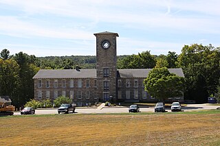
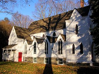
The Tariffville Historic District is a 93 acres (38 ha) historic district in the town of Simsbury, Connecticut. It was listed on the National Register of Historic Places in 1993. It is part of the Tariffville section of Simsbury. The district includes 165 contributing buildings and two contributing sites. It also includes 26 non-contributing buildings and 4 non-contributing sites. There are several houses in the district of Gothic Revival style, probably following designs from pattern books of architect Andrew Jackson Downing. The Trinity Episcopal Church is the only building in the district designed by an architect of national standing, namely Henry C. Dudley. Many of the homes in the area were built by the Tariff Manufacturing Company, which opened a carpet mill along the Farmington River, and needed housing for workers.

The Hotchkissville Historic District is a historic district in the town of Hotchkissville, Connecticut adjacent to Woodbury, Connecticut that was listed on the National Register of Historic Places in 1995. It encompasses most of the historic village of Hotchkissville, which is centered at the junction of Washington and Weekeepeemee Roads. The village began as a dispersed rural agricultural community, but developed in the 19th century with the arrival of industry, primarily the manufacture of textiles. Despite this, the village has retained a significantly rural character, and includes a broad cross-section of 18th- and 19th-century architectural styles. Notable residents include the Wols family.
The Pine Meadow Historic District encompasses most of the historic 19th-century village of Pine Meadow in New Hartford, Connecticut. Located at a bend in the West Branch of the Farmington River southeast of New Hartford center, it is a well-preserved example of a rural industrial village. The district was listed on the National Register of Historic Places in 1996.
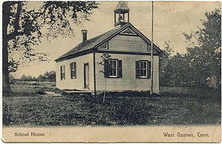
The West Goshen Historic District is a historic district in the village of West Goshen in the town of Goshen, Connecticut. It encompasses a well-preserved early 19th-century industrial village, with twenty historically significant properties in the village, most of which lie on Connecticut Route 4 between Beach Street and Thompson Road. The district was listed on the National Register of Historic Places in 1987.

The Central Village Historic District is a historic district in the Central Village area of Plainfield, Connecticut that was listed on the National Register of Historic Places (NRHP) in 1991. It encompasses a late 19th-century historic mill village, including a small commercial center where Connecticut Route 12 and 14 meet, a cluster of architecturally distinguished buildings built by mill owners and managers, and a collection of mill worker housing units. It includes the Plainfield Woolen Company Mill, which is separately listed, as well as archaeological remnants of other mill infrastructure. It also includes Plainfield's old town hall and high school. Other architecturally prominent buildings include the c. 1855 Italianate mansion of mill owner Arthur Fenner, and the 1845 Greek Revival Congregational Church.

The Cushman Village Historic District is a historic district encompassing a portion of the Cushman Village area of Amherst, Massachusetts, which was a significant mill village during the 19th century. It is centered on the triangle formed by Bridge, Henry, and Pine Streets in northeastern Amherst, and arose because of the presence of falls on the Mill River, whose water power was harnessed for mills as early as the mid-18th century. Two houses survive from the colonial period. The village, although it was defined for many years by the mills, no longer has any industrial buildings, as they were demolished or destroyed by fire. Most of the houses in the district were built before 1860, the peak of the village's industrial activity. The district was listed on the National Register of Historic Places in 1992.

The Graniteville Historic District is a mainly residential historic district in Waterford, Connecticut. It is ranged along Rope Ferry Road, near granite quarries that were once a major industry in the town. Most of the 31 historical buildings in the district are plain residences occupied by quarry workers; also included are the c. 1878 Graniteville School at 239 Rope Ferry Road, and the house of John Palmer, one of the proprietors of the quarries, at 218 Rope Ferry Road. His house, a c. 1860 Italianate updating of an older house, is the most elaborate house in the district. The district was listed on the National Register of Historic Places in 2003.

The Curtisville Historic District encompasses a predominantly residential area along Naubuc Avenue and Pratt Streets in northwestern Glastonbury, Connecticut. Developed mainly in the 19th century, it illustrates the coexistence of agricultural and industrial pursuits in a single village area, mixing worker housing, former farm properties, and a small mill complex. The district was listed on the National Register of Historic Places in 1992.

The Union Village Historic District encompasses the core of a historic 19th-century residential mill village in Manchester, Connecticut. Radiating north and west from the junction of Union Street and North Main Street, the area was developed in the first half of the 19th century has a company town, but evolved into a mixed working-class community in the 20th century. It was listed on the National Register of Historic Places in 2002.

The Manchaug Village Historic District is a historic district encompassing the 19th century industrial village center of Manchaug in Sutton, Massachusetts. Developed in the 1820s around textile mills on the Mumford River, it was the largest industrial area in Sutton, with at least three mill complexes in operation. The district is centered on the junction of Main Street with Manchaug, Putnam Hill, and Whitins Roads.


