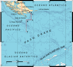
The Sea of the Southern Zone (Spanish : Mar de la Zona Austral) [1] or Southern Zone Sea is the name given by Argentina and Chile to the maritime area whose boundaries were undefined, located south of the Isla Grande de Tierra del Fuego. This maritime space was subject to delimitation in the Treaty of Peace and Friendship of 1984 between Chile and Argentina, which ended the Beagle conflict or "Southern Zone conflict."
The definition of this maritime area was constrained by the necessity for the parties ratifying the treaty to avoid referring to the area under delimitation as part of either the Atlantic Ocean or the Pacific Ocean, since the two countries could not agree on its affiliation to one ocean or the other. After the signing of the treaty in 1984 and its ratification in 1985, the name "Sea of the Southern Zone" has been largely ignored in both countries, which continue to use their traditional names in cartographic representations of the area. For this reason, parts of this sea are sometimes linked to the Argentine Sea, Chilean Sea or the Drake Passage.
The name "Sea of the Southern Zone" has not been adopted internationally, and the International Hydrographic Organization did not include the Sea of the Southern Zone in the draft of the 4th edition of its publication Limits of Oceans and Seas, issued via Circular CL55 of 7 November 2001 (the 3rd edition dates from 1953). [2] In this draft, Chile, in agreement with Russia and the United Kingdom, proposed as the northern limit of the Drake Passage the line connecting Waterman Island, Cape Horn, Cape San Bartolomé on Isla de los Estados, and the southern coast of that island to Cape San Juan de Salvamento, clearly overlapping areas under the delimitation of the Sea of the Southern Zone. [3]
The boundaries of the Sea of the Southern Zone have only been precisely defined in its northern part, where it reaches the shores of Isla de los Estados from its eastern extremity, the mouth of the Le Maire Strait, and the coast on the Isla Grande de Tierra del Fuego to the eastern mouth of the Beagle Channel at Cape San Pío. To the west, it extends at least to the Chilean straight baselines — though it is unclear whether it extends further west — which skirt the southeast coast of Isla Nueva, the Evout and Barnevelt islets, Deceit Island, and Hornos Island, continuing south to the meridian of Cape Horn. The eastern boundary has not been defined, reaching at least the polygonal line defined in the treaty between points A and E, leaving the connection between point F of the polygon and the eastern extremity of Isla de los Estados undefined. It is not specified whether it extends to the limit of the Argentine exclusive economic zone that was part of the conflict.
Researchers have proposed that the separation of the Pacific and Atlantic Ocean oceans "could be confirmed from the so-called Shackleton fracture zone ... the boundary is then located east of the so-called Cape Horn Meridian". [4]
The United Nations Convention on the Law of the Sea (UNCLOS) of April 30, 1982, which entered into force on November 16, 1994, established the regime of the continental shelf in Part VI (Articles 76 to 85), defining in Article 76, paragraph 1 what is understood as a continental shelf.
Argentina ratified the convention on January 12, 1995, and it came into force for the country on December 31, 1995.
On August 25, 1997, Chile signed and ratified the United Nations Convention on the Law of the Sea, and it entered into force for the country on September 24, 1997. [5]
In 2009, Argentina submitted a presentation to the United Nations Commission on the Limits of the Continental Shelf, which was accepted in 2016 by the UNCLOS. [6] The map in the submission included the disputed territories with the United Kingdom, such as the Falkland Islands, South Georgia, and South Sandwich Islands, a crescent-shaped area south of Argentina's territorial sea as defined in the 1984 treaty with Chile. [7] This area was also claimed by Chile as part of its presential sea, [8] and the sea surrounding the Antarctic Peninsula, which is claimed by all three aforementioned countries. [9] That same year, on May 8, Chile submitted its Preliminary Report to the United Nations Commission on the Limits of the Continental Shelf. [10] [11] [12]
In 2020, the Argentine Chamber of Deputies unanimously approved the outer limit of the Argentine Continental Shelf in Law 27,557. [13]
That same year, on December 21, Chile submitted to the United Nations Commission on the Limits of the Continental Shelf the partial report on the extended continental shelf in Easter Island and Salas y Gómez. [14] [15]
In 2021, Chilean President Sebastián Piñera signed Supreme Decree No. 95, which outlined the continental shelf east of the 67º 16' 0 meridian as part of Chile's continental shelf (not the extended one) area projected from the Diego Ramírez Islands, also claiming the crescent area that Argentina considers part of its extension achieved under the extended continental shelf principle. [16] [17] [18] This was reflected in the SHOA Chart No. 8 [19] and prompted a response from the Argentine Foreign Ministry against Chile's measure. [20] [21] [22] [23] [24] [25] [26] [27]
In February 2022, Chile submitted its second partial presentation regarding the Western Continental Shelf of the Chilean Antarctic Territory. [28] [29] In August of the same year, Chile made the oral presentations of both partial submissions during the 55th Session of the Commission on the Limits of the Continental Shelf at the United Nations in New York. [30] [5]
In 2023, Chile, through SHOA, made available an illustrative graphic showing all the maritime areas claimed by the country, which was once again rejected by Argentina. [31] [32] [33] [34]
In July 2023, the International Court of Justice ruled on the priority of a Continental Shelf over a Extended Continental Shelf in the case of the territorial and maritime dispute between Colombia and Nicaragua. [35]{{cite web}}
: CS1 maint: numeric names: authors list (link)The United Nations Convention on the Law of the Sea (UNCLOS), also called the Law of the Sea Convention or the Law of the Sea Treaty, is an international treaty that establishes a legal framework for all marine and maritime activities. As of October 2024, 169 sovereign states and the European Union are parties.
The geography of Argentina is heavily diverse, consisting of the Andes Mountains, pampas, and various rivers and lakes. Bordered by the Andes in the west and the South Atlantic Ocean to the east, its neighbouring countries are Chile to the west, Bolivia and Paraguay to the north, and Brazil and Uruguay to the northeast.
Territorial waters are informally an area of water where a sovereign state has jurisdiction, including internal waters, the territorial sea, the contiguous zone, the exclusive economic zone, and potentially the extended continental shelf. In a narrower sense, the term is often used as a synonym for the territorial sea.
An exclusive economic zone (EEZ), as prescribed by the 1982 United Nations Convention on the Law of the Sea, is an area of the sea in which a sovereign state has exclusive rights regarding the exploration and use of marine resources, including energy production from water and wind.
The Beagle conflict was a border dispute between Chile and Argentina over the possession of Picton, Lennox and Nueva islands and the scope of the maritime jurisdiction associated with those islands that brought the countries to the brink of war in 1978.
The Chilean Sea is the portion of the Pacific Ocean lying west of the Chilean mainland. The official Chilean usage for Chilean Sea was defined on 30 May 1974 when the Diario oficial de la Republica de Chile published Supreme Decree #346, which declared that "the waters surrounding or touching the shores of the national territory shall be known as Mar Chileno."
The Chilean Antarctic Territory, or Chilean Antarctica, is a part of West Antarctica and nearby islands claimed by Chile. It comprises the region south of 60°S latitude and between longitudes 53°W and 90°W, partially overlapping the Antarctic claims of Argentina and the United Kingdom. It constitutes the Antártica commune of Chile.
International relations between the Republic of Chile and the Argentine Republic have existed for decades. The border between the two countries is the world's third-longest international border, which is 5,300 km (3,300 mi) long and runs from north to south along the Andes mountains. Although both countries gained their independence during the South American wars of liberation, during much of the 19th and the 20th century, relations between the countries were tense as a result of disputes over the border in Patagonia. Despite this, Chile and Argentina have never been engaged in a war with each other. In recent years, relations have improved. Argentina and Chile have followed quite different economic policies. Chile has signed free trade agreements with countries such as China, the United States, Canada, South Korea, as well as European Union, and it's a member of the APEC. Argentina belongs to the Mercosur regional free trade area. In April 2018, both countries suspended their membership from the UNASUR.
The Argentine Sea is a marginal sea of the Atlantic Ocean adjacent to the southern tip of South America. It ranges from the mouth of the estuary of the Río de la Plata in the north to the Isla de los Estados in the south, and from the Argentine coast to the 200 meters isobath. Its width varies between 210 km in front of Mar del Plata and 850 km at the latitude of the Falkland Islands. The coastline extends for 4,725 km. To the east of the Argentine Sea extends much deeper and more extensive Argentine Basin.
The region of the Beagle Channel, explored by Robert FitzRoy in the 1830s, was one of the last to be colonized by Chile and Argentina. The cold weather, the long distances from other inhabited regions, and the shortage of transport and subsistence, kept it far from the governmental task.
The Treaty of Peace and Friendship of 1984 between Chile and Argentina was signed into agreement at the Vatican on 29 November 1984.
Tricontinental Chile is a geopolitical concept denoting Chile's unique position with its mainland in South America, Easter Island in Oceania (Polynesia) and the Chilean Antarctic Territory in Antarctica. This concept is built on the basis that there are Chilean territories as far away from the mainland as to be considered part of Polynesia and on a larger scale, Oceania, and Chile's claims to Antarctica provide it a basis for claiming to be a part of Antarctica as well.
The Argentina–Chile border is the longest international border of South America and the third longest in the world after the Canada–United States border and the Kazakhstan–Russia border. With a length of 5,308 kilometres (3,298 mi), it separates Argentina from Chile along the Andes and on the islands of Tierra del Fuego. However, there are some border disputes, particularly around the Southern Patagonian Ice Field. It is the largest border of the two countries, beating the Argentina–Paraguay and Chile–Bolivia, Argentina's and Chile's second largest borders, respectively.
Brazil's jurisdictional waters, also known as the Blue Amazon, are the riverine and oceanic spaces over which Brazil exerts some degree of jurisdiction over activities, persons, installations and natural resources through the Brazilian Navy's supervision. They comprise internal waters, the territorial sea, exclusive economic zone (EEZ) and waters overlying the continental shelf where it exceeds the EEZ, for a total claimed area of 5,669,852.41 square kilometers, equivalent to 67% of the country's territory on land. 2,094,656.59 km2 consist of the post-EEZ shelf, a stretch of seabed yet to be recognized by the United Nations (UN). Brazilian claims of jurisdiction over its overlying waters are controversial, as they lie in the high seas.
The natural delimitation between the Pacific and South Atlantic Oceans by the Scotia arc is a hydrographical concept developed in Chile in 1952 in which it was postulated that the boundary between the southeast Pacific Ocean and the southwest Atlantic Ocean should not be the meridian of Cape Horn but rather follow the line of the Scotia Arc, an underwater mountain range which links the Tierra del Fuego archipelago with the Antarctic continent.
A presential sea, zone of maritime presence or heritage marine reserve is a zone of influence demarcated by a maritime country in the high seas adjacent to its exclusive economic zone (EEZ). The objective of this oceanopolitical concept or doctrine, is to signal to third parties where the coastal country's interests are, or could be directly involved.
The Southern Patagonian ice field dispute is a border dispute between Argentina and Chile over the delineation of the boundary line between the two countries on the Southern Patagonian Ice Field, a large expanse of glaciers located in the Patagonian Andes, which is the largest non-polar continental ice field with land access. It is called continental ice in Argentina and southern ice field in Chile, to differentiate it from the northern ice field. 2024, the Argentine–Chilean border in this sector is still pending of definition according to the 1998 agreement signed by both countries. The original border was defined 100 years prior on 1 October 1898 by experts from both countries.
The extended continental shelf, scientific continental shelf, or outer continental shelf, refers to a type of maritime area, established as a geo-legal paradigm by the United Nations Convention on the Law of the Sea (UNCLOS). Through the process known as the extension of the outer limit of the continental shelf or establishment of the outer edge of the continental margin, every coastal state has the privilege, granted by the international community of nations, to acquire exclusive and perpetual rights to exploit the biotic and abiotic resources found on the seabed and subsoil of these maritime areas. These areas are located beyond the 200 nautical miles that make up the state's exclusive economic zone (EEZ) and would otherwise be considered international waters.
The dispute over the extended continental shelf in the Southern Zone Sea between Argentina and Chile is a disagreement between the two countries over a maritime area of 5,302 km² that began after Argentina attempted to extend its maritime space based on the theory of the extended continental shelf over the Southern Zone Sea, south of Point F as agreed in the 1984 treaty, in an area claimed by Chile as part of its "presential sea", and now as part of its continental shelf projected from the Diego Ramírez Islands.
The continental shelf of Chile is the underwater extension adjacent to the Chilean coasts that stretches from the shoreline to the edge of the continental shelf in the Pacific Ocean and the Southern Ocean.