Southside, West Virginia | |
---|---|
Coordinates: 38°43′00″N81°58′07″W / 38.71667°N 81.96861°W Coordinates: 38°43′00″N81°58′07″W / 38.71667°N 81.96861°W | |
Country | United States |
State | West Virginia |
County | Mason |
Elevation | 564 ft (172 m) |
Time zone | UTC-5 (Eastern (EST)) |
• Summer (DST) | UTC-4 (EDT) |
ZIP code | 25187 [1] |
Area code(s) | 304 & 681 |
GNIS feature ID | 1547094 [2] |
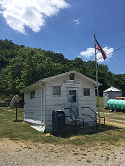
Southside is an unincorporated community in Mason County, West Virginia, United States. Southside is located near the Kanawha River south of Leon. It is currently served by U.S. Route 35, but will be bypassed once the planned upgrading of that route into a four-lane highway is complete. [3]
Located near Southside are the Couch-Artrip House and Elm Grove, both of which are listed on the National Register of Historic Places. [4]
Woodlawn is an unincorporated community and census-designated place in Baltimore County, Maryland. Per the 2020 census, the population was 39,986. It is home to the headquarters of the Social Security Administration (SSA) and the Centers for Medicare and Medicaid Services (CMS). It is bordered by Catonsville on the south, by the Patapsco River and Howard County on the west, by Randallstown and Lochearn to the north, and by the City of Baltimore to the east. Parts of Woodlawn are sometimes informally referred to as Security, Maryland, due to the importance of the SSA's headquarters as well as nearby Security Boulevard and Security Square Mall.
Tesuque is a census-designated place (CDP) in Santa Fe County, New Mexico, United States. It is part of the Santa Fe, New Mexico, Metropolitan Statistical Area. The population was 909 at the 2000 census. The area is separate from but located near Tesuque Pueblo, a member of the Eight Northern Pueblos, and the Pueblo people are from the Tewa ethnic group of Native Americans who speak the Tewa language. The pueblo was listed as a historic district on the National Register of Historic Places in 1973.
Chautauqua is a town and lake resort community in Chautauqua County, New York, United States. The population was 4,017 at the 2020 census. The town is named after Chautauqua Lake. It is the home of the Chautauqua Institution and the birthplace of the Chautauqua Movement.
Deerpark is a town in the western part of Orange County, New York, United States, and part of the New York metropolitan area. As of the 2020 Census, the population was at 7,509. The center of population of New York is located in Cuddebackville, a hamlet in Deerpark. Cuddebackville and Deerpark most prominently serve as the headquarters of both the global Falun Gong religious movement and the Shen Yun performance arts troupe, based at the Dragon Springs compound.
Schodack is a town in Rensselaer County, New York, United States. The population was 12,965 at the 2020 census. The town name is derived from the Mahican word, Escotak. The town is in the southwestern part of the county. Schodack is southeast of Albany, New York.
Cumru Township is a township in Berks County, Pennsylvania, United States. The population was 15,638 at the 2020 census. Nolde Forest Environmental Education Center, a Pennsylvania state park, is in Cumru Township.
Sevierville is a city in and the county seat of Sevier County, Tennessee, located in eastern Tennessee. The population was 17,889 at the 2020 United States Census.
Alberta is a town in Brunswick County, Virginia, United States. The population was 298 at the 2010 census. It is home to the Christanna Campus of Southside Virginia Community College.
Burkeville is a town in Nottoway County, Virginia, United States. The population was 432 at the 2010 census. The source of the town name is disputed. The town is located on the crossroads of U.S. Routes 360 and 460.
Crewe is a town in Nottoway County, Virginia, United States. The population was 2,326 at the 2010 census.
Richlands is a town in Tazewell County, Virginia, United States. The population was 5,823 at the 2010 census. It is part of the Bluefield, WV-VA micropolitan area which has a population of 107,578.
Swan Quarter is an unincorporated community and census-designated place (CDP) in Hyde County, North Carolina, United States. It is the Hyde county seat. As of the 2010 census it had a population of 324.
Blounts Creek is a small unincorporated rural community in Beaufort County, North Carolina, United States, situated near a creek with the same name.
Darlington is an unincorporated community and census-designated place in northeastern Harford County, Maryland, United States. The population was 409 at the 2010 census. The center of the community was listed on the National Register of Historic Places as the Darlington Historic District in 1987. Median household income is $66,563. The percentage of people in poverty is 5.3%.
Ridgeway is an unincorporated community in Berkeley County, West Virginia, United States. It lies off U.S. Route 11 on Specks Run Road near the Virginia state line.
Cuylerville is a hamlet in the Town of Leicester, in Livingston County, New York, United States. The population was 297 at the 2010 census, which lists the community as a census-designated place.
Morristown is an unincorporated community and census-designated place (CDP) in Maricopa County, Arizona, United States. It is 43 miles (69 km) northwest of Phoenix, at the junction of State Route 74 and U.S. Route 60. As of the 2020 census, it had a population of 186, down from 227 in 2010.
Salado is an Incorporated community and census-designated place (CDP) in Independence County, Arkansas, United States. It was first listed as a CDP in the 2020 census with a population of 472.
The Joseph Bell DeRemer House is a Dutch Colonial Revival style house located on Belmont Road in the Near Southside Historic District of Grand Forks, North Dakota, United States. The house was built in 1906 for the architect Joseph Bell DeRemer, who designed the home himself. As an example of a middle-class house the structure is remarkable for details and quality associated with the public and commercial buildings designed by the DeRemer firm.
Southside is an unincorporated community in Montgomery County, Tennessee, United States. Southside is located in the southeast corner of the county, 11.5 miles (18.5 km) south-southeast of Clarksville. Southside had a post office until it closed on October 12, 2002; it still has its own ZIP code, 37171.