Arbuckle District, Mason County, West Virginia

Last updated

Arbuckle District, Mason
County, West Virginia
Mason County Arbuckle District Highlighted.png
Location of Arbuckle District in Mason County
Coordinates: 38°44′00″N82°01′52″W / 38.73333°N 82.03111°W / 38.73333; -82.03111
Country United States
State West Virginia
County Mason
Established1863
Named for William Arbuckle
Area
[1]
  Total66.31 sq mi (171.7 km2)
  Land65.03 sq mi (168.4 km2)
  Water1.28 sq mi (3.3 km2)
Elevation
[2]
833 ft (254 m)
Population
 (2020) [3]
  Total1,054
  Density17/sq mi (7/km2)
Time zone UTC-5 (Eastern (EST))
  Summer (DST) UTC-4 (EDT)
GNIS feature ID1928162 [2]

Arbuckle Magisterial District is one of ten magisterial districts in Mason County, West Virginia, United States. The district was originally established as a civil township in 1863, and converted into a magisterial district in 1872. [4] In 2020, Arbuckle District was home to 1,054 people. [3]

Contents

Geography

Arbuckle District is located in the central portion of Mason County, between the Kanawha River and the northern end of Putnam County. To the north, it is bounded by the Kanawha River, and by Lewis and Cooper Districts; to the northeast by the Kanawha and Cologne District; to the east by the Kanawha and Union District; to the south by the Buffalo-Union District of Putnam County, formerly Buffalo District; and to the west and southwest by Clendenin District in Mason County. [5] [6] [7] [8] [9] [10]

Occupying over sixty-six square miles, Arbuckle is the second-largest of Mason County's ten magisterial districts; only Clendenin District is larger. [1] Its northern and eastern boundary runs for sixteen miles along the Kanawha River. About sixty percent of the district is hilly, and topped with a soil containing white, red, and yellow clay. The remainder of the district consists of bottomlands, with a soil consisting of white and blue clay mixed with black loam. [5]

Streams

The district's main streams all empty into the Kanawha River, and are named for the distance that their ends lie above the mouth of the Kanawha, or did at the time of the first settlement: Threemile, Fivemile, Lower and Upper Ninemile, Little Sixteenmile and Big Sixteenmile Creeks. [5]

Threemile Creek drains the western end of Arbuckle District, and empties into the Kanawha a little below the mouth of another, more extensive creek also named Threemile, on the north side of the Kanawha, in Lewis and Cooper Districts. Fivemile has an extensive course on the Kanawha River Bottom, where its right-hand fork branches off to the west as Little Fivemile Creek. The main branch flows out of the hills behind Couch, where it divides into Lower Fivemile Creek, to the west, and extending into Clendenin District; and Upper Fivemile Creek, to the east, running past the village of Fivemile. Similarly, Lower and Upper Ninemile Creeks converge on the river bottom below Beech Hill. In the hills Lower Ninemile meets with Middle Ninemile Creek, which runs past Pine Grove Church and the former village of Stockton, while Upper Ninemile flows out of the hills north of the former village of Flaxton, both now part of the Chief Cornstalk Wildlife Management Area. [7] [6] [11] [12]

Little Sixteenmile flows south out of the hills around Condee, above which the main branch converges with the Shady Fork; from Condee, the creek turns eastward before reaching the river bottom at Southside. Little Sixteen then meanders northward across the floodplain, running parallel to the Kanawha for more than two miles, before discharging into the river. The upper waters of Big Sixteenmile Creek, also known as Kanawha Sixteenmile, or just Sixteen, arise in the southeastern part of Clendenin District, with the main branch and the Five Fork Branch flowing out of the hills of Crooked Ridge, Mount Union Ridge, and Dunlavy Ridge, converging before flowing eastward into Arbuckle District just above the former village of Siloam. The creek continues east past Barn Hollow, then is joined by more branches flowing south from Hambrick Ridge and north from Dunlavy, and finally leaves the hills below McCausland. Sixteenmile then meanders north for about a mile along the base of the hills, before turning eastward and flowing across the plain to the Kanawha. [6] [9] [12] [13]

Other streams in Arbuckle District include McCausland Run, which joins the Kanawha just below the Putnam County line, opposite Robertsburg; Pond Branch, which empties into the Kanawha above Ninemile; and Twomile Creek, which runs just inside the northeastern boundary with Clendenin District. The upper waters of the Ohio Sixteenmile Creek arise in the western part of Arbuckle District; the main branch meets with Wolfpen Run, and joins with the Willow Branch, flowing southward out of Arbuckle District just above Arlee. [6] [9] [8] [12] [13]

Communities

There are no incorporated towns in Arbuckle District, but there are several unincorporated communities, including Beech Hill, Condee, Couch, Fivemile, McCausland, Southside, and the former villages of Flaxton, Siloam and Veranda. [7] [6] [8] [9]

Nine miles from the mouth of the Kanawha, Beech Hill is the largest village in Arbuckle District. [5] The village is thought to have taken its name from the Beech Hill Methodist Episcopal Church, built there in 1860; and the church was named for the numerous beech trees that covered the hill. [14] In the latter part of the nineteenth century, Beech Hill was the site of a large lumber depot, established by Robert Alexander in 1866. Alexander was also Beech Hill's first postmaster, from 1868 to 1872. There was a steamboat landing, sheltered from ice floes by a bend in the river, and another landing across the river at Beech Hill Station, or Debby Post Office, in Cooper District. A ferry carried passengers back and forth between the two sides. [5] [15] [8]

Roads and travel

The only highway in Arbuckle District is U.S. Route 35, which runs from Scott Depot in Putnam County to Henderson, in Clendenin District, before crossing the Ohio River. For most of its length in Arbuckle District, Route 35 parallels the river at the base of the hills, but for about six miles the highway moves into the hills, diverting heavy traffic from its former route, now West Virginia Route 817, known locally as Kanawha Valley Road.

There are currently no Kanawha River crossings in Arbuckle District. Until the twentieth century, ferries carried passengers across the river at Ambrosia, Beech Hill, Leon, and Grimms Landing. [7] [8] [9]

History

Historical population
CensusPop.Note
1870 1,301
1880 2,04056.8%
1890 2,1173.8%
1900 2,48517.4%
1910 2,365−4.8%
1920 1,928−18.5%
1930 1,655−14.2%
1940 1,7093.3%
1950 1,273−25.5%
1960 1,085−14.8%
1970 1,048−3.4%
1980 1,16811.5%
1990 881−24.6%
2000 1,08022.6%
2010 1,1213.8%
2020 1,054−6.0%
United States Census Bureau,
U.S. Decennial Census,
1870–2020. [16]

According to Hardesty's Biographical Atlas of Mason County, the first resident of Arbuckle District was a squatter named Macky, who built a cabin at the mouth of Big Sixteenmile Creek circa 1794. The first regular settler was a man named Ayres, who built his homestead at the mouth of Little Sixteenmile about 1800. They were followed by John Coffman, Nathan Long, Adam Long, William Arbuckle, Andrew Bryan, Charles Day, and Thomas Saunders. William Sterrett, who for twenty-seven years was Clerk of the Mason County Court, was another early settler of the district. [5]

In 1814, John Koontz built a horse-powered grist mill on Fivemile Creek, the first mill within the present limits of Arbuckle District. In 1818, twenty-eight students attended the first school, held in a log cabin by a teacher named Payne. William George, a Baptist minister who had first come to the district in 1811, organized the Harmony church at the mouth of Little Sixteen in 1821; several years later, he would found a church of the same name in Union District. [5]

After West Virginia gained its independence from Virginia in 1863, the legislature enacted a law requiring the counties to be divided into civil townships. Mason County was divided into ten townships, each of which was named after a pioneer settler of Mason County. Arbuckle Township was named in honor of William Arbuckle, one of the county's earliest settlers, whose homestead stood on Thirteenmile Creek, now in Union District. It is the only Arbuckle District in the state. Like the other townships, Arbuckle was converted into a magisterial district in 1872. [4]


Related Research Articles

<span class="mw-page-title-main">Mason County, West Virginia</span> County in West Virginia, United States

Mason County is a county in the U.S. state of West Virginia. As of the 2020 census, the population was 25,453. Its county seat and largest city is Point Pleasant. The county was founded in 1804 and named for George Mason, delegate to the U.S. Constitutional Convention. Before the Civil War, the county was in the State of Virginia.

<span class="mw-page-title-main">Kanawha County, West Virginia</span> County in West Virginia, United States

Kanawha County is a county in the U.S. state of West Virginia. As of the 2020 census, the population was 180,745, making it West Virginia's most populous county. The county seat is Charleston, which is also the state capital. Kanawha County is part of the Charleston, WV Metropolitan Statistical Area.

<span class="mw-page-title-main">Graham District, Mason County, West Virginia</span> Magisterial district in West Virginia, United States

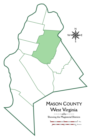
Graham Magisterial District is one of ten magisterial districts in Mason County, West Virginia, United States. The district was originally established as a civil township in 1863, and converted into a magisterial district in 1872. In 2020, Graham District was home to 2,618 people.

<span class="mw-page-title-main">Waggener District, Mason County, West Virginia</span> Magisterial district in West Virginia, United States

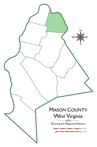
Waggener Magisterial District is one of ten magisterial districts in Mason County, West Virginia, United States. The district was originally established as a civil township in 1863, and converted into a magisterial district in 1872. In 2020, Waggener District was home to 2,483 people.

<span class="mw-page-title-main">Cooper District, Mason County, West Virginia</span> Magisterial district in West Virginia, United States

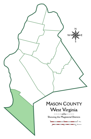
Cooper Magisterial District is one of ten magisterial districts in Mason County, West Virginia, United States. The district was originally established as a civil township in 1863, and converted into a magisterial district in 1872. In 2020, Cooper District was home to 1,700 people.

<span class="mw-page-title-main">Robinson District, Mason County, West Virginia</span> Magisterial district in West Virginia, United States

Robinson Magisterial District is one of ten magisterial districts in Mason County, West Virginia, United States. The district was originally established as a civil township in 1863, and converted into a magisterial district in 1872. In 2020, Robinson District was home to 3,166 people.

<span class="mw-page-title-main">Lewis District, Mason County, West Virginia</span> Magisterial district in West Virginia, United States

Lewis Magisterial District is one of ten magisterial districts in Mason County, West Virginia, United States. The district was originally established as a civil township in 1863, and converted into a magisterial district in 1872. In 2020, Robinson District was home to 5,635 people.

<span class="mw-page-title-main">Cologne District, Mason County, West Virginia</span> Magisterial district in West Virginia, United States

Cologne Magisterial District is one of ten magisterial districts in Mason County, West Virginia, United States. The district was originally established as a civil township in 1863, and converted into a magisterial district in 1872. In 2020, Cologne District was home to 1,413 people.

<span class="mw-page-title-main">Union District, Mason County, West Virginia</span> Magisterial district in West Virginia, United States

Union Magisterial District is one of ten magisterial districts in Mason County, West Virginia, United States. The district was originally established as a civil township in 1863, and converted into a magisterial district in 1872. In 2020, Union District was home to 1,261 people.

<span class="mw-page-title-main">Clendenin District, Mason County, West Virginia</span> Magisterial district in West Virginia, United States

Clendenin Magisterial District is one of ten magisterial districts in Mason County, West Virginia, United States. The district was originally established as a civil township in 1863, and converted into a magisterial district in 1872. In 2020, Clendenin District was home to 3,435 people.

<span class="mw-page-title-main">Hannan District, Mason County, West Virginia</span> Magisterial district in West Virginia, United States

Hannan Magisterial District is one of ten magisterial districts in Mason County, West Virginia, United States. The district was originally established as a civil township in 1863, and converted into a magisterial district in 1872. In 2020, Clendenin District was home to 2,688 people.

<span class="mw-page-title-main">Grant District, Jackson County, West Virginia</span> Magisterial district in West Virginia, United States

Grant District, formerly Grant Magisterial District, is one of five historic magisterial districts in Jackson County, West Virginia, United States. The district was originally established as a civil township in 1863, and converted into a magisterial district in 1872. When Jackson County was redistricted in the 1990s, the area of Grant District was included in the new Northern Magisterial District. However, the county's historic magisterial districts continue to exist in the form of tax districts, serving all of their former administrative functions except for the election of county officials.

<span class="mw-page-title-main">Ravenswood District, Jackson County, West Virginia</span> Magisterial district in West Virginia, United States

Ravenswood District, formerly Ravenswood Magisterial District, is one of five historic magisterial districts in Jackson County, West Virginia, United States. The district was originally known as Gilmore Township, one of five civil townships established in 1863; the name officially became "Ravenswood" in 1871, and Jackson County's townships were converted into magisterial districts in 1872. When Jackson County was redistricted in the 1990s, the area of Ravenswood District was divided between the new Northern and Western Magisterial Districts. However, the county's historic magisterial districts continue to exist in the form of tax districts, serving all of their former administrative functions except for the election of county officials.

<span class="mw-page-title-main">Union District, Jackson County, West Virginia</span> Magisterial district in West Virginia, United States

Union District, formerly Union Magisterial District, is one of five historic magisterial districts in Jackson County, West Virginia, United States. The district was originally known as Hushan's Mills Township, one of five civil townships established in 1863, at the height of the Civil War; it was subsequently given the patriotic name of Union Township. In 1872, West Virginia's townships were converted into magisterial districts. When Jackson County was redistricted in the 1990s, the area of Union District was included in the new Western Magisterial District. However, the county's historic magisterial districts continue to exist in the form of tax districts, serving all of their former administrative functions except for the election of county officials.

<span class="mw-page-title-main">Ripley District, Jackson County, West Virginia</span> Magisterial district in West Virginia, United States

Ripley District, formerly Ripley Magisterial District, is one of five historic magisterial districts in Jackson County, West Virginia, United States. The district was originally known as Mill Creek Township, one of five civil townships established in Jackson County after West Virginia became a state in 1863; it was renamed "Ripley Township" after its chief town in 1871, and the following year, all of West Virginia's townships were converted into magisterial districts. When Jackson County was redistricted in the 1990s, the area of Ripley District was divided between the new Eastern and Western Magisterial Districts. However, the county's historic magisterial districts continue to exist in the form of tax districts, serving all of their former administrative functions except for the election of county officials.

<span class="mw-page-title-main">Washington District, Jackson County, West Virginia</span> Magisterial district in West Virginia, United States

Washington District, formerly Washington Magisterial District, is one of five historic magisterial districts in Jackson County, West Virginia, United States. The district was originally established as one of five civil townships in Jackson County after West Virginia became a state in 1863; in 1872, all of West Virginia's townships were converted into magisterial districts. When Jackson County was redistricted in the 1990s, Washington District was combined with the eastern portion of Ripley District, including the city of Ripley, to form the new Eastern Magisterial District. However, the county's historic magisterial districts continue to exist in the form of tax districts, serving all of their former administrative functions except for the election of county officials.

<span class="mw-page-title-main">Northern District, Jackson County, West Virginia</span> Magisterial district in West Virginia, United States

The Northern Magisterial District is one of three magisterial districts in Jackson County, West Virginia, United States. It was established during a process of redistricting undertaken in the 1990s. In 2010, 8,753 people lived in the district.

<span class="mw-page-title-main">Eastern District, Jackson County, West Virginia</span> Magisterial district in West Virginia, United States

The Eastern Magisterial District is one of three magisterial districts in Jackson County, West Virginia, United States. It was established during a process of redistricting undertaken in the 1990s. In 2010, 9,882 people lived in the district.

<span class="mw-page-title-main">Western District, Jackson County, West Virginia</span> Magisterial district in West Virginia, United States

The Western Magisterial District is one of three magisterial districts in Jackson County, West Virginia, United States. It was established during a process of redistricting undertaken in the 1990s. In 2010, 10,576 people lived in the district.

References

  1. 1 2 United States Census Bureau, National County Subdivisions Gazetteer File: West Virginia, retrieved 8 October 2019.
  2. 1 2 "US Board on Geographic Names". United States Geological Survey. August 23, 2001. Retrieved October 17, 2019.
  3. 1 2 United States Census Bureau, 2020 Decennial Census.
  4. 1 2 "Division of the County into Townships", in Hardesty's Biographical Atlas of Mason County, West Virginia, H.H. Hardesty & Co., New York, Toledo, and Chicago (1882).
  5. 1 2 3 4 5 6 7 "Arbuckle District", in Hardesty's Biographical Atlas of Mason County.
  6. 1 2 3 4 5 United States Geological Survey, Topographical Maps, West Virginia-Ohio, Glenwood Quadrangle (ed. 1906).
  7. 1 2 3 4 United States Geological Survey, Topographical Maps, West Virginia–Ohio, Point Pleasant Quadrangle (ed. Sept. 1908).
  8. 1 2 3 4 5 United States Geological Survey, Topographical Maps, West Virginia–Ohio, Ravenswood Quadrangle (ed. Nov. 1908).
  9. 1 2 3 4 5 United States Geological Survey, Topographical Maps, West Virginia, Winfield Quadrangle (ed. Nov. 1908).
  10. "U.S. Census Bureau Geography Profile: Arbuckle District, Mason County, West Virginia" . Retrieved October 17, 2019.
  11. United States Geological Survey, Topographical Maps, West Virginia-Mason County, Beech Hill Quadrangle (ed. 1957, rev. 1975).
  12. 1 2 3 United States Geological Survey, Topographical Maps, West Virginia, Arlee Quadrangle (ed. 1958, rev. 1975).
  13. 1 2 United States Geological Survey, Topographical Maps, West Virginia, Robertsburg Quadrangle (ed. 1958, rev. 1975, 1987).
  14. Hamill Kenny, West Virginia Place Names: Their Origin and Meaning, including the Nomenclature of the Streams and Mountains, Place Name Press, Piedmont, W.Va. (1945), p. 102.
  15. United States Post Office Department, Record of Appointment of Postmasters, 1832–1971, NARA Microfilm Publication M841, West Virginia, Mason County.
  16. 1870:1870 Census: Volume 1. The Statistics of the Population of the United States (1872). Table III: "Population of Civil Divisions Less than Counties", p. 285 (West Virginia), continued. 1880:1880 Census: Volume 1. Statistics of the Population of the United States (1883). Table III: "Population of Civil Divisions Less than Counties", p. 364 (West Virginia), continued. 1890:Eleventh Census - Volume 1. (Part I & Part II) Report on Population of the United States (1895). Table 5, "Population of States and Territories by Minor Civil Divisions: 1880 and 1890", p. 355 (West Virginia), continued. 1900:1900 Census: Volume I. Population, Part 1 (1901). Table 5, "Population of States and Territories by Minor Civil Divisions: 1890 and 1900", p. 410 (West Virginia), continued. 1910:1910 Census: Volume 3. Population, Reports by States, with Statistics for Counties, Cities, and Other Civil Divisions: Nebraska-Wyoming, Alaska, Hawaii, and Porto Pico (1913). West Virginia, p. 1020, Table 1, "Population of Minor Civil Divisions: 1910, 1900, and 1890", continued. 1920:1920 Census: Volume 1. Population, Number and Distribution of Inhabitants (1921). West Virginia, p. 664, Table 53, "Population of Counties by Minor Civil Divisions: 1920, 1910, and 1900", continued. 1930:1930 Census: Volume 1. Population, Number and Distribution of Inhabitants (1931). West Virginia, p. 1297, Table 21, "Population by Sex, Color, Age, etc., for Counties by Minor Civil Divisions: 1930", continued. 1940:1940 Census of Population: Volume 1. Number of Inhabitants. Total Population for States, Counties, and Minor Civil Divisions; for Urban and Rural Areas; for Incorporated Places; for Metropolitan Districts; and for Census Tracts (1942). West Virginia, p. 1149, Table 4, "Population of Counties by Minor Civil Divisions: 1920 to 1940", continued. 1950:1950 Census of Population: Volume 2. Characteristics of the Population (1953), Part 48, West Virginia, p. 48-10, Table 6, "Populations of Counties by Minor Civil Divisions: 1930–1950", continued. 1960:1960 Census: Population, Volume 1. Characteristics of the Population (1961). Part 50: West Virginia, p. 50-12, Table 7: "Population of Counties by Minor Civil Divisions", 1940–1960, continued. 1970:1970 Census – Population, Advance Report: Final Population Counts (1970). West Virginia, p. 5, Table 2, "Population of County Subdivisions: 1970 and 1960", continued. 1980:Characteristics of the Population: General Social and Economic Characteristics: 1980 (1983). Part 50: West Virginia, p. 50–100, Table 44, "General Characteristics for Counties and County Subdivisions: 1980", continued. 1990:1990 Census of Population: General Population Characteristics (1992). Part 50: West Virginia, p. 169, Table 76, "General Characteristics of Persons, Households, and Families: 1990", continued. 2000:Summary Population and Housing Characteristics (2002). Part 50: West Virginia, p. 10, Table 1, "Age and Sex: 2000", continued.