Special routes of U.S. Route 87 in Texas

Last updated
Special routes of U.S. Route 87

Business plate.svg

US 87.svg

Business Loop 27.svg Texas Loop blank.svg
A special or former route of U.S. Route 87 in Texas may be signed as a normal U.S. Route business loop, as a business loop of Interstate 27, or as another state highway loop
System links

The following routes - special routes, state highway loops, and Interstate business loops (of Interstate 27) - exist or existed parallel to U.S. Highway 87 in the U.S. state of Texas, mostly along a former alignment.

Contents

Stockdale

Business plate.svg

US 87.svg

Business U.S. Highway 87

Location Stockdale
Existedmid-1965–present
Texas Loop 411.svg

Business U.S. Highway 87-U is the old route of US 87 through Stockdale. It was formed on May 31, 1965 as Loop 411, but always marked as a business route of US 87; On June 21, 1990 the official designation was changed to Business US 87. [1] [2]

La Vernia

Texas Loop 321.svg

State Highway Loop 321

Location La Vernia
Existedmid=1957–present

Loop 321 is the old route of US 87 through La Vernia, formed in on July 16, 1957. [3]

San Antonio

Texas Spur 345.svg

State Highway Spur 345

Location San Antonio
Existed1962–present
Texas Loop 345.svg

Spur 345 is the old route of US 87 through northern San Antonio, formed on January 26, 1962, as Loop 345. It begins at I-10/US 87 at Woodlawn Avenue, and runs northwest on Fredericksburg Road to I-10/US 87 near Huebner Road. When first designated, Loop 345 was marked as a business route of US 87. On December 18, 2014, the section of Loop 345 from I-410 south to I-10 was removed from the state highway system, and the rest was redesignated as Spur 345. [4]


Boerne

Business plate.svg

US 87.svg

Business U.S. Highway 87

Location Boerne
Length4.81 mi (7.74 km)

Business US Highway 87 follows the old route of US 87 through Boerne. Though signs as a business route, it is not recognized as one by the Texas Department of Transportation. The route runs from westbound I-10, and the overlap with northbound US 87 from Exits 542 to 537.

Comfort

Business plate.svg

US 87.svg

Business U.S. Highway 87

Location Comfort

Business US Highway 87 follows the old route of US 87 through Comfort. The route runs from westbound I-10, and the overlap with northbound US 87 from northbound only Exit 524 at a wye interchange to Exit 523 at a diamond interchange. It also contains a short overlap with Texas State Highway 27.

Big Spring

Business plate.svg

US 87.svg

Business U.S. Highway 87

Location Big Spring
Length5.5 mi [5]  (8.9 km)
Existed2013 [5] –present

Business US Highway 87-M follows the old route of US 87 through Big Spring. The highway was designated in 2013 with the construction of a new expressway route for US 87 around the town. [5] [6] The expressway south of I-20 opened to traffic in 2016 while the northern section is currently under construction. [7]

Junction list

The entire route is in Howard County.

Locationmi [8] kmDestinationsNotes
0.00.0US 87.svgSouth plate.svg
Texas RM 33.svg
US 87  / RM 33 south San Angelo, Garden City
Interchange; southern terminus; southbound exit and northbound entrance
Big Spring 2.94.7Texas FM 700.svg FM 700 Interchange
4.47.1East plate green.svg
Business Loop 20.svg
I-20 BL east (West 4th Street)
West plate green.svg
Business Loop 20.svg
I-20 BL west (West 5th Street)
5.58.9I-20.svgUS 87.svg I-20  / US 87  El Paso, Fort Worth, Lamesa Current northern terminus; I-20 exit 177
1.000 mi = 1.609 km; 1.000 km = 0.621 mi

Vick

Texas Loop 577.svg

State Highway Loop 577

Location Vick
Existed1991–present

Loop 577 is the old route of US 87 through Vick, formed October 6, 1991. [9] About midway, it intersects the south end of FM 381.

Wall

Texas Loop 570.svg

State Highway Loop 570

Location Wall
Existed1990–present

Loop 570 is the old route of US 87 through Wall, formed on March 19, 1990. [10]

Lamesa

Business plate.svg

US 87.svg

Business U.S. Highway 87

Location Lamesa
Existed1946–present

Business U.S. Highway 87-K is the old route of US 87 through Lamesa.

Texas Loop 218.svg

It was formed on December 10, 1946 as Loop 218 on Lynn Avenue. On June 21, 1990 the official designation was changed to Business US 87, and on January 2, 1992, US 87 and Business US 87 were swapped, placing the former on Lynn Avenue and the latter on Dallas Avenue. [11] [12]

Tahoka

Texas Loop 472.svg

State Highway Loop 472

Location Tahoka
Existed1969–present

Loop 472 is the old route of US 87 through Tahoka, formed on January 31, 1969. [13]

Woodrow

Texas Loop 493.svg

State Highway Loop 493

Location Woodrow
Existed1970–present

Loop 493 is the old route of US 87 through Woodrow, formed in late 1970. When first designated, Loop 493 was marked as a business route of US 87. [14]

Lubbock

Business plate.svg

US 87.svg

Business U.S. Highway 87

Location Lubbock
Length3.833 mi [15]  (6.169 km)
ExistedMay 27, 1992–February 25, 2010 [15]

Business U.S. Highway 87-G was the old route of US 87 through Lubbock, formed in mid-1992 when Interstate 27 was completed and US 87 was moved onto it. The highway traveled along Avenue A, beginning at a junction with I-27 / US 87 / US 84, running northward to a junction with I-27 / US 87 / US 82.

On February 25, 2010, Business U.S. Highway 87-G was cancelled, and TxDOT transferred ownership of the road to the city of Lubbock. [15]

Junction list

The entire route was in Lubbock, Lubbock County.

mi [16] kmDestinationsNotes
0.00.0I-27.svgUS 87.svgUS 84.svg I-27  / US 87  / US 84 (Slaton Road)I-27 exit 1
1.93.1East plate.svg
Texas FM 835.svg
FM 835 east (34th Street)
3.86.1I-27.svgUS 87.svgUS 82.svg I-27  / US 87  / US 82 (4th Street)I-27 exit 4
1.000 mi = 1.609 km; 1.000 km = 0.621 mi

New Deal

Texas Loop 461.svg

State Highway Loop 461

Location New Deal
Length1.719 mi [17]  (2.766 km)
ExistedApril 1, 1968–present

Loop 461 is the old route of US 87 through New Deal, stretching 1.719 miles (2.766 km) along Monroe Avenue, between exits 13 and 15 of I-27/US 87. It was authorized on April 1, 1968, after the new US 87 freeway was built, and initially marked as a business route of US 87. [17] Along the way, it intersects FM 1729 (Main Street).

Abernathy

Texas Loop 369.svg

State Highway Loop 369

Location Abernathy
Length1.496 mi [18]  (2.408 km)
ExistedOctober 15, 1962–present

Loop 369 is the old route of US 87 through Abernathy, stretching 1.496 miles (2.408 km) along Avenue D, between exits 20 and 22 of I-27/US 87. It was authorized on October 15, 1962, after the new US 87 freeway was built. [18] Along the way, it intersects FM 597 (1st Street).

Hale Center

Business Interstate 27-T (TX).svg

Business Interstate 27-T

Location Hale Center
Length1.168 mi [19]  (1.880 km)
ExistedApril 5, 2002–present

Business Interstate 27-T is the old route of US 87 through Hale Center, stretching 1.168 miles (1.880 km) along Main Street, between exits 36 and 38 of I-27/US 87. It was bypassed in about 1962, [20] but was turned over to the city until April 5, 2002, when the new business route was authorized. [19] Along the way, it intersects FM 1914 (Cleveland Street).

Plainview

Business Interstate 27-U (TX).svg

Business Interstate 27-U

Location Plainview
Length9.282 mi [21]  (14.938 km)
ExistedFebruary 15, 1967–present

Business Interstate 27-U is the old route of US 87 through Plainview, stretching 9.282 miles (14.938 km) along Columbia Street, between exits 45 and 53 of I-27/US 87. It was originally authorized as Loop 445 on February 15, 1967, after the new US 87 freeway was built, and marked as a business route of US 87. [22] On January 14, 1991, Loop 445 was renamed Business I-27. [21] Along the way, it intersects FM 3466 (South 4th Street), US 70 (5th Street), and FM 1767 (34th Street).

Amarillo

Texas Loop 434.svg

State Highway Loop 434

Location Amarillo
Length4.999 mi [23]  (8.045 km)
Existed1966–present

Loop 434 is the old route of US 87 through northern Amarillo, formed on August 31, 1966. [23] The highway is known locally as River Road.

Loop 434 begins at a junction with US 87 / US 287 near the Amarillo Zoo and Wonderland Park. The highway travels in a northern direction through suburban areas, with the route becoming more rural towards the north. Loop 434 ends at an intersection with the northbound frontage road of US 87 / US 287 near River Road High School.

Junction list

The entire route is in Potter County.

Locationmi [24] kmDestinationsNotes
Amarillo 0.00.0US 87.svgUS 287.svg US 87  / US 287 (Dumas Drive)
1.32.1Texas Loop 335.svg Loop 335 (St. Francis Avenue)
4.97.9North plate.svg
US 87.svg
North plate.svg
US 287.svg
US 87 north / US 287 north
1.000 mi = 1.609 km; 1.000 km = 0.621 mi

Dalhart

Business plate.svg

US 87.svg

Business U.S. Highway 87

Location Dalhart
Existed1954–present

Business U.S. Highway 87-B is a loop of US 87 through Dalhart. It was formed in early 1954 as Loop 276, but always marked as a business route of US 87; in early 1991 the official designation was changed to Business US 87. [25] [26]

Related Research Articles

<span class="mw-page-title-main">Interstate 27</span> Interstate in the Texas Panhandle

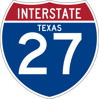
Interstate 27 (I-27) is an Interstate Highway, entirely in the US state of Texas, running north from Lubbock to I-40 in Amarillo. These two cities are the only control cities on I-27; other cities and towns served by I-27 include New Deal, Abernathy, Hale Center, Plainview, Kress, Tulia, Happy, and Canyon. In Amarillo, I-27 is commonly known as the Canyon Expressway, although it is also called Canyon Drive on its access roads. I-27 was officially designated the Marshall Formby Memorial Highway after former attorney and Texas State Senator Marshall Formby in 2005. The entire length of I-27 replaced U.S. Route 87 (US 87) for through traffic.

<span class="mw-page-title-main">U.S. Route 80</span> Numbered Highway in the United States

U.S. Route 80 or U.S. Highway 80 (US 80) is a major east-west United States Numbered Highway in the Southern United States, much of which was once part of the early auto trail known as the Dixie Overland Highway. As the "0" in the route number indicates, it was originally a cross-country route, from the Pacific Ocean to the Atlantic Ocean. Its original western terminus was at Historic US 101 in San Diego, California. However, the entire segment west of Dallas, Texas, has been decommissioned in favor of various Interstate Highways and state highways. Currently, the highway's western terminus is at an interchange with Interstate 30 (I-30) on the Dallas–Mesquite, Texas city line. Its eastern terminus is in Tybee Island, Georgia near the Atlantic Ocean. Between Jonesville, Texas and Kewanee, Mississippi, US 80 runs parallel to or concurrently with Interstate 20. It also currently runs through Dallas, Texas; Shreveport, Louisiana; Jackson, Mississippi; Montgomery, Alabama; Columbus, Georgia; Macon, Georgia; and Savannah, Georgia.

<span class="mw-page-title-main">U.S. Route 290</span> Highway in Texas

U.S. Route 290 is an east–west U.S. Highway located entirely within the state of Texas. Its western terminus is at Interstate 10 southeast of Segovia, and its eastern terminus is at Interstate 610 in northwest Houston. It is the main highway between Houston and Austin and is a cutoff for travelers wanting to bypass San Antonio on Interstate 10. Throughout its length west of Austin, US 290 cuts across mountainous hills comprising the Texas Hill Country and the Edwards Plateau; between Austin and Houston, the highway then travels through gradually hilly grasslands and pine forests comprising the Gulf Coastal Plains.

<span class="mw-page-title-main">Texas State Highway 46</span> State highway in Texas

State Highway 46 is a 71.4-mile (114.9 km) state highway in the U.S. state of Texas that runs from SH 16 east of Bandera to the intersection of SH 123 and SH 123 Business just south of Seguin.

<span class="mw-page-title-main">U.S. Route 59 in Texas</span>

U.S. Highway 59 (US 59) in the U.S. state of Texas is named the Lloyd Bentsen Highway, after Lloyd Bentsen, former U.S. senator from Texas. In northern Houston, US 59, co-signed with Interstate 69 (I-69), is the Eastex Freeway. To the south, which is also co-signed with I-69, it is the Southwest Freeway. The stretch of the Southwest Freeway just west of The Loop was formerly one of the busiest freeways in North America, with a peak AADT of 371,000 in 1998.

<span class="mw-page-title-main">U.S. Route 54 in Texas</span> Section of U.S. Highway in Texas

U.S. Route 54 in Texas is a U.S. Highway that travels through two portions of the state: one in the far western point, and the other in the far northwest Panhandle.

<span class="mw-page-title-main">U.S. Route 75 in Texas</span> Highway in Texas

U.S. Highway 75 (US 75) is a part of the U.S. Highway System that travels from Interstate 345 (I-345) in Dallas, Texas northward to the Canadian border at Noyes, Minnesota. In the state of Texas it runs from I-345 in Dallas and heads north to the Oklahoma state line.

<span class="mw-page-title-main">Interstate 27 Business (Plainview, Texas)</span>

Business Interstate 27-U is a business loop in the US state of Texas. It stretches 9.282 miles (14.938 km) along Columbia Street through Plainview between exits 45 and 53 on Interstate 27 (I-27). The highway follows the original alignment of U.S. Route 87 (US 87) prior to the construction of the new freeway to the west. Before becoming Bus. I-27-U, it was designated as State Highway Loop 445 (Loop 445) and signed as a business route of US 87. Along the way, it intersects Farm to Market Road 3466, US 70 (5th Street), and FM 1767 (34th Street).

<span class="mw-page-title-main">Texas State Highway Loop 369</span>

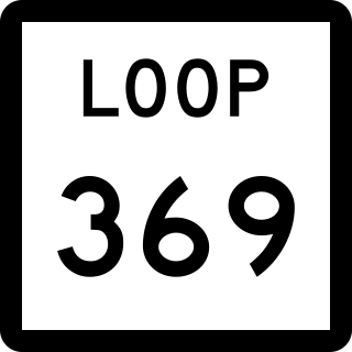
Loop 369, the Abernathy Loop, is a state highway in the U.S. state of Texas. It stretches 1.496 miles (2.408 km) along Avenue D through Abernathy, between exits 20 and 22 of Interstate 27/U.S. Highway 87. It was authorized on October 15, 1962, after the new US 87 freeway was built. Along the way, it intersects Farm to Market Road 597.

<span class="mw-page-title-main">Texas State Highway Loop 461</span>

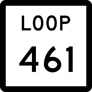
Loop 461, the New Deal Loop, is a state highway in the U.S. state of Texas. It stretches 1.719 miles (2.766 km) along Monroe Avenue through New Deal, between exits 13 and 15 of Interstate 27/U.S. Highway 87. It was authorized on April 1, 1968, after the new US 87 freeway was built, and initially marked as US 87 Business. Along the way, it intersects Farm to Market Road 1729.

<span class="mw-page-title-main">Texas State Highway Spur 345</span>

Spur 345 is a 4.538-mile-long (7.303 km) loop route through the city of San Antonio in the U.S. state of Texas. It follows a former route of U.S. Highway 87 (US 87), which it now separates from, about 4.5-mile (7.242 km) north of Balcones Heights on the outskirts of San Antonio, on the way into that city. The road is a major arterial for San Antonio and a main route into Balcones Heights, providing access to the United Services Automobile Association (USAA) headquarters as well as to the South Texas Medical Center.

<span class="mw-page-title-main">Business routes of Interstate 35</span>

There are fourteen business routes of Interstate 35 (I-35): nine are in Texas, two are in Iowa, and three are in Minnesota.

<span class="mw-page-title-main">Business routes of Interstate 10</span> United States highway system

Interstate business routes are roads connecting a central or commercial district of a city or town with an Interstate bypass. These roads typically follow along local streets often along a former US route or state highway that had been replaced by an Interstate. Interstate business route reassurance markers are signed as either loops or spurs using a green shield shaped and numbered like the shield of the parent Interstate highway.

<span class="mw-page-title-main">Special routes of U.S. Route 67</span>

Numerous special routes of U.S. Route 67, all business routes, exist. One other route, formerly an alternate route in western Illinois, has since been downgraded to state Route 267.

<span class="mw-page-title-main">Business routes of Interstate 20 in Texas</span>

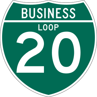
All of the business loops within Texas are maintained by the Texas Department of Transportation (TxDOT). Interstate 20 (I-20) has fifteen business loops in the state, all located in western Texas. Along I-20, TxDOT identifies each business route as Business Interstate 20 followed by an alphabetic suffix. Along Texas Interstates, the alphabetic suffixes on business route names ascend eastward and northward. There are gaps in the alphabetic values to allow for future system expansion. The alphabetic naming suffixes are included as small letters on the bottom of route shields.

<span class="mw-page-title-main">Business routes of Interstate 25</span> Route system

Interstate business routes are roads connecting a central or commercial district of a city or town with an Interstate bypass. These roads typically follow along local streets often along a former U.S. Route or state highway that had been replaced by an Interstate. Interstate business route reassurance markers are signed as either loops or spurs using a green shield shaped sign and numbered like the shield of the parent Interstate highway.

<span class="mw-page-title-main">U.S. Route 287 Business (Mansfield–Fort Worth, Texas)</span>

Business US Highway 287-P is a 38.613-mile-long (62.142 km) business loop of US Highway 287 in the state of Texas that serves as main street for Mansfield, downtown Fort Worth and Saginaw. The highway is known as Main Street while in Mansfield, Mansfield Highway while in southern Fort Worth, Kennedale Parkway in Kennedale, Riverside Drive and Rosedale Street in central Fort Worth, Commerce Street in downtown Fort Worth, Main Street in northern Fort Worth, and Saginaw Boulevard in Saginaw. The highway was originally designated on January 14, 1991, to replace a portion of Loop 496, and the old route of US 287 and US 81. The route was then rerouted several times during the 1990s. Bus. US 287-P is located almost entirely in Tarrant County, and is mostly located in Fort Worth. The highway is, as of 2010, the longest business route of US 287, while located in Texas. Bus. US 287-P is one of the few highways to be designated as a north–south highway.

<span class="mw-page-title-main">Business routes of Interstate 40</span> Highway system

Interstate business routes are roads connecting a central or commercial district of a city or town with an Interstate bypass. These roads typically follow along local streets often along a former U.S. Route or state highway that had been replaced by an Interstate. Interstate business route reassurance markers are signed as either loops or spurs using a green shield shaped and numbered like the shield of the parent Interstate highway.

<span class="mw-page-title-main">Business routes of Interstate 45</span>

All of the business loops are maintained by the Texas Department of Transportation (TxDOT). Interstate 45 (I-45) has four business loops in the state, all located in northern Texas. Along I-45, TxDOT identifies each business route as Business Interstate 45 followed by an alphabetic suffix. Along Texas Interstates, the alphabetic suffixes on business route names ascend eastward and northward. There are gaps in the alphabetic values to allow for future system expansion. The alphabetic naming suffixes are included as small letters on the bottom of route shields.

References

  1. Texas Department of Transportation, Highway Designation File: State Highway Loop No. 411
  2. Texas Department of Transportation, Highway Designation File: Business U.S. Highway No. 87-U
  3. Texas Department of Transportation, Highway Designation File: State Highway Loop No. 321
  4. Texas Department of Transportation, Highway Designation File: State Highway Loop No. 345
  5. 1 2 3 Transportation Planning and Programming Division (n.d.). "Business U.S. Highway No. 87-M". Highway Designation Files. Texas Department of Transportation. Retrieved January 1, 2019.
  6. "US 87 Truck Relief Route". Texas Department of Transportation. Retrieved April 8, 2019.
  7. Bennett, Stephanie (July 14, 2016). "Big Spring to Open New Highway". KOSA-TV . Retrieved April 8, 2019.
  8. Google (April 8, 2019). "Route of Bus. US 87-M" (Map). Google Maps. Google. Retrieved April 8, 2019.
  9. Texas Department of Transportation, Highway Designation File: State Highway Loop No. 577
  10. Texas Department of Transportation, Highway Designation File: State Highway Loop No. 570
  11. Texas Department of Transportation, Highway Designation File: State Highway Loop No. 218
  12. Texas Department of Transportation, Highway Designation File: Business U.S. Highway No. 87-K
  13. Texas Department of Transportation, Highway Designation File: State Highway Loop No. 472
  14. Texas Department of Transportation, Highway Designation File: State Highway Loop No. 493
  15. 1 2 3 Texas Department of Transportation, Highway Designation File: Business U.S. Highway No. 87-G
  16. Google (August 16, 2018). "Route of Bus. US 87-G" (Map). Google Maps. Google. Retrieved August 16, 2018.
  17. 1 2 Texas Department of Transportation, Highway Designation File: State Highway Loop No. 461
  18. 1 2 Texas Department of Transportation, Highway Designation File: State Highway Loop No. 369
  19. 1 2 Texas Department of Transportation, Highway Designation File: Business Interstate Highway No. 27-T
  20. Federal Highway Administration, National Bridge Inventory, 2006
  21. 1 2 Texas Department of Transportation, Highway Designation File: Business Interstate Highway No. 27-U
  22. Texas Department of Transportation, Highway Designation File: State Highway Loop No. 445
  23. 1 2 Texas Department of Transportation, Highway Designation File: State Highway Loop No. 434
  24. Google (August 16, 2018). "Route of Loop 434" (Map). Google Maps. Google. Retrieved August 16, 2018.
  25. Texas Department of Transportation, Highway Designation File: State Highway Loop No. 276
  26. Texas Department of Transportation, Highway Designation File: Business U.S. Highway No. 87-B