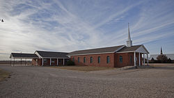
Woodrow, Texas

Last updated

Woodrow, Texas
Woodrow Texas Church 2012.jpg
One of four churches in Woodrow
Relief map of Texas.png
Red pog.svg
Woodrow
Usa edcp relief location map.png
Red pog.svg
Woodrow
Coordinates: 33°26′48″N101°50′39″W / 33.44667°N 101.84417°W / 33.44667; -101.84417 [1]
Country Flag of the United States.svg  United States
State Flag of Texas.svg  Texas
County Lubbock
Physiographic region Llano Estacado
Founded1910s
Elevation
[1]
3,182 ft (970 m)
Time zone UTC-6 (Central (CST))
  Summer (DST) UTC-5 (CDT)
Area code 806
Website Handbook of Texas

Woodrow is an unincorporated community in southern Lubbock County, Texas, United States. It lies on U.S. Route 87, ten miles south of Lubbock, and has an estimated population of 85. It is part of the Lubbock Metropolitan Statistical Area.

Contents

History

Established in the mid 1910s, Woodrow is one of the newest communities in Lubbock County. Upon its establishment, a bit of controversy arose over the new community's name. It was agreed to name it after President Woodrow Wilson, but there was argument over whether the name was to be "Woodrow" or "Wilson". The choice of Woodrow was finally settled on, possibly because there was already a Wilson in neighboring Lynn County. [2]

The community's first school opened in 1917. As the twentieth century progressed the need arose to improve Lubbock County's rural schools, and as a result the Cooper School was built in Woodrow in 1936. Originally a combined elementary/middle/high school, the Cooper School evolved into the Lubbock-Cooper Independent School District which serves much of rural southern Lubbock County.

Education

Woodrow is served by the Lubbock-Cooper Independent School District.

See also

Related Research Articles

<span class="mw-page-title-main">Wilson, Texas</span> City in Texas, United States

Wilson is a small rural city in the northeastern quadrant of Lynn County, Texas, United States. As of the 2010 census, the population was 489.

<span class="mw-page-title-main">Cotton Center, Texas</span> Unincorporated community in Texas, United States

Cotton Center is an unincorporated community in western Hale County, Texas, United States, located about 12 miles southwest of Hale Center. Until the late 19th century, the Comanche tribe of Native Americans occupied the area. In 1907, with the coming of a branch of the Santa Fe Railroad, a number of farming operations were established. Cotton Center was originally created in 1925 as a consolidated school district, with a small unincorporated community site, containing the school, cotton gins, and various businesses to support the surrounding farms. In 1935, a local post office opened, and the first irrigation well was drilled. By the late 1940s, irrigation wells proliferated, pumping water from the Ogallala Aquifer. The community revolves around farming and is tied together by the school, which as of 2005 had 140 students in prekindergarten through grade 12.

<span class="mw-page-title-main">Whitharral, Texas</span> Unincorporated community in Texas, United States

Whitharral is an unincorporated community in Hockley County, Texas, United States.

<span class="mw-page-title-main">Afton, Texas</span> Unincorporated community in Texas, United States

Afton is an unincorporated community in northern Dickens County, Texas, United States.

<span class="mw-page-title-main">McAdoo, Texas</span> Unincorporated community in Texas, United States

McAdoo is an unincorporated community in northwestern Dickens County, Texas, United States.

<span class="mw-page-title-main">Acuff, Texas</span> Unincorporated community in Texas, United States

Acuff is an unincorporated farming community in northeastern Lubbock County, Texas, United States. It is part of the Lubbock Metropolitan Statistical Area.

<span class="mw-page-title-main">Slide, Texas</span> Unincorporated community in Texas, United States

Slide is an unincorporated community in Lubbock County, Texas, United States. It lies at the junction of FM 1730 and FM 41, 13 miles south of Lubbock, and has an estimated population of 44. The community is part of the Lubbock metropolitan area.

<span class="mw-page-title-main">Southland, Texas</span> Unincorporated community in Texas, United States

Southland is an unincorporated community in Garza County, Texas, United States. It lies along the eastern edge of the Llano Estacado on U.S. Route 84, twenty miles northwest of Post.

<span class="mw-page-title-main">Cone, Texas</span> Unincorporated community in Texas, United States

Cone is an unincorporated community in Crosby County, Texas, United States. It lies on U.S. Route 62, thirty-four miles northeast of Lubbock, has an estimated population of 70, and is the location of the Harmony Plains Singing School.

<span class="mw-page-title-main">Dougherty, Floyd County, Texas</span> Unincorporated community in Texas, United States

Dougherty is a small unincorporated community in Floyd County, Texas, United States.

<span class="mw-page-title-main">Kalgary, Texas</span> Unincorporated community in Texas, United States

Kalgary is an unincorporated community in Crosby County, Texas, United States. According to the Handbook of Texas, the community had an estimated population of 70 in 2000.

<span class="mw-page-title-main">Bula, Texas</span> Unincorporated community in Texas, United States

Bula is an unincorporated community in Bailey County, Texas, United States. According to the Handbook of Texas, the community had a population of 35 in 2000.

<span class="mw-page-title-main">Posey, Texas</span> Unincorporated community in Texas, United States

Posey is an unincorporated community located on the level plains of the Llano Estacado, approximately 11 mi (18 km) southeast of Lubbock in southeastern Lubbock County, Texas, United States.

<span class="mw-page-title-main">Heckville, Texas</span> Unincorporated community in Texas, United States

Heckville is an unincorporated community located on the high plains of the Llano Estacado, approximately 16 mi (26 km) northeast of Lubbock or 7 mi (11 km) north of Idalou in northeastern Lubbock County, Texas, United States. This small town was named after Henry Heck, who built a cotton gin to serve the community in 1948.

<span class="mw-page-title-main">Becton, Texas</span> Unincorporated community in Texas, United States

Becton is an unincorporated community in northeastern Lubbock County, Texas, United States, approximately 18 mi (29 km) northeast of Lubbock. This small rural community lies on the high plains of the Llano Estacado in West Texas.

<span class="mw-page-title-main">Close City, Texas</span> Unincorporated community in Texas, United States

Close City is an unincorporated community in western Garza County, approximately 6.5 mi (10.5 km) west-northwest of Post. The small rural community lies on the High Plains of the Llano Estacado in West Texas.

<span class="mw-page-title-main">Needmore, Terry County, Texas</span> Unincorporated community in Texas, United States

Needmore is a small unincorporated community in north central Terry County, Texas, United States.

<span class="mw-page-title-main">Hobbs, Texas</span> Unincorporated community in Texas, United States

Hobbs is an unincorporated community in west Fisher County, Texas, United States. It is located at the intersection of Farm to Market Roads 611 and 1614, about 20 mi (32 km) east of Snyder. It lies within the physiographic region known as the Rolling Plains in the valley of the Clear Fork Brazos River.

<span class="mw-page-title-main">Roundup, Texas</span> Unincorporated community in Texas, United States

Roundup is an unincorporated community located in northeastern Hockley County, Texas, United States. The town is located on the high plains of the Llano Estacado at the intersection of U.S. Route 84 and Farm to Market Road 2130 between Anton and Shallowater.

<span class="mw-page-title-main">Whiteflat, Texas</span> Ghost Town in Texas, United States

Whiteflat is a ghost town in Motley County, Texas, United States. The population was estimated to be 3 at the 2000 census.

References

  1. 1 2 "Woodrow". Geographic Names Information System . United States Geological Survey, United States Department of the Interior.
  2. "Woodrow, TX". The Handbook of Texas online. Retrieved December 6, 2012.