Reese Center, Texas

Last updated
Reese Center, Texas
Former CDP
TXMap-doton-ReeseCenter.PNG
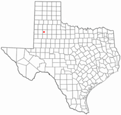
Location of Reese Center, Texas
Lubbock County ReeseCenter.svg
Coordinates: 33°35′36″N102°1′48″W / 33.59333°N 102.03000°W / 33.59333; -102.03000
Country United States
State Texas
County Lubbock
Area
  Total6.5 sq mi (16.9 km2)
  Land6.5 sq mi (16.9 km2)
  Water0.0 sq mi (0.0 km2)
Population
 (2000)
  Total42
  Density6.4/sq mi (2.5/km2)
Time zone UTC-6 (Central (CST))
  Summer (DST) UTC-5 (CDT)
FIPS code 48-61406 [1]

Reese Center is an unincorporated community and former census-designated place (CDP) in Lubbock County, Texas, United States. The population was 42 at the 2000 census. Its population was not recorded separately for the 2010 census. It is part of the Lubbock Metropolitan Statistical Area.

Contents

Geography

Reese Center is located at 33°35′36″N102°1′48″W / 33.59333°N 102.03000°W / 33.59333; -102.03000 (33.593363, -102.030076). [2] The community is bordered by the former Reese Air Force Base to the west and by the city of Lubbock to the south and east.

According to the United States Census Bureau, the CDP had a total area of 6.5 square miles (17 km2), all land.

Demographics

As of the census [1] of 2000, there were 42 people, 13 households, and 10 families residing in the CDP. The population density was 6.4 people per square mile (2.5/km2). There were 14 housing units at an average density of 2.1/sq mi (0.8/km2). The racial makeup of the CDP was 95.24% White, 2.38% Native American, 2.38% from other races. Hispanic or Latino of any race were 14.29% of the population.

There were 13 households, out of which 69.2% had children under the age of 18 living with them, 84.6% were married couples living together, and 15.4% were non-families. 15.4% of all households were made up of individuals, and 7.7% had someone living alone who was 65 years of age or older. The average household size was 3.23 and the average family size was 3.55.

In the CDP the population was spread out, with 38.1% under the age of 18, 40.5% from 25 to 44, 11.9% from 45 to 64, and 9.5% who were 65 years of age or older. The median age was 34 years. For every 100 females, there were 133.3 males. For every 100 females age 18 and over, there were 136.4 males.

The median income for a household in the CDP was $23,750, and the median income for a family was $12,292. Males had a median income of $11,250 versus $11,250 for females. The per capita income for the CDP was $7,393. None of the population or families were below the poverty line.

See also

Related Research Articles

Tolsona is a census-designated place (CDP) in Copper River Census Area, Alaska, United States. The population was 12 at the 2020 census, down from 30 in 2010.

Birch Creek is a census-designated place (CDP) in Yukon-Koyukuk Census Area, Alaska, United States. The population was 33 at the 2010 census, up from 28 in 2000.

<span class="mw-page-title-main">Avra Valley, Arizona</span> CDP in Pima County, Arizona

Avra Valley is a census-designated place (CDP) in Pima County, Arizona, United States. The population was 6,050 at the 2010 census, up from 5,038 in 2000.

<span class="mw-page-title-main">Ak-Chin Village, Arizona</span> CDP in Pinal County, Arizona

Ak-Chin Village is a census-designated place (CDP) in Pinal County, Arizona, United States on the Ak-Chin (Maricopa) Reservation. The population was 862 at the 2010 census, up from 669 in 2000.

<span class="mw-page-title-main">West Crossett, Arkansas</span> CDP in Arkansas, United States

West Crossett is a census-designated place (CDP) in Ashley County, Arkansas, United States. Per the 2020 census, the population was 1,144.

<span class="mw-page-title-main">Tobin, California</span> Census-designated place in California, United States

Tobin is a census-designated place (CDP) in Plumas County, California, United States. The population was 12 at the 2010 census, up from 11 at the 2000 census.

<span class="mw-page-title-main">Carrick, California</span> Census-designated place in California

Carrick is a census-designated place (CDP) in Siskiyou County, California, United States. Its population is 143 as of the 2020 census, up from 131 from the 2010 census. Carrick is located just outside the town of Weed, uses Weed in its mailing addresses and is generally viewed by locals as a neighborhood of Weed, though located outside of the city proper. On September 15, 2014, Carrick was under mandatory evacuation order due to a forest fire.

<span class="mw-page-title-main">Zellwood, Florida</span> Census-designated place in Florida, United States

Zellwood is a census-designated place and an unincorporated area in Orange County, Florida, United States. The population was 2,817 at the 2010 census. It is part of the Orlando–Kissimmee Metropolitan Statistical Area.

<span class="mw-page-title-main">Fort Riley-Camp Whiteside, Kansas</span> Former CDP in Kansas, United States

Fort Riley-Camp Whiteside is a former census-designated place (CDP) that covers part of Fort Riley, a US Army installation in Geary County, Kansas, United States. The population was 103 at the 2000 census. The area was not recorded as a CDP for the 2010 census.

<span class="mw-page-title-main">Massac, Kentucky</span> Census-designated place in Kentucky, United States

Massac is a census-designated place (CDP) in McCracken County, Kentucky, United States. The population was 4,635 at the 2020 census. It is part of the Paducah, KY-IL Micropolitan Statistical Area.

<span class="mw-page-title-main">St. Xavier, Montana</span> Unincorporated community and census-designated place in Montana, United States

St. Xavier is an unincorporated community and census-designated place (CDP) in Big Horn County, Montana, United States. The CDP population was 83 at the 2010 census.

<span class="mw-page-title-main">Old Agency, Montana</span> CDP in Montana, United States

Old Agency is a census-designated place (CDP) in Sanders County, Montana, United States. The population was 95 at the 2000 census.

<span class="mw-page-title-main">Four Bears Village, North Dakota</span> CDP in North Dakota, United States

Four Bears Village is a census-designated place (CDP) in McKenzie County, North Dakota, United States. The population was 500 at the 2020 census.

Iron Post is a census-designated place (CDP) in Mayes County, Oklahoma, United States. The population was 117 at the 2000 census, but had declined to 92 in 2010, a loss of more than 21 percent.

Privateer is a census-designated place (CDP) in Sumter County, South Carolina, United States. The population was 2,118 at the 2000 census. It is included in the Sumter, South Carolina Metropolitan Statistical Area.

<span class="mw-page-title-main">Tynan, Texas</span> Census-designated place in Texas, United States

Tynan is a census-designated place (CDP) in Bee County, Texas, United States. The population was 278 at the 2010 census.

<span class="mw-page-title-main">Bixby, Texas</span> CDP in Texas, United States

Bixby is a census-designated place (CDP) in Cameron County, Texas, United States. The population was 504 at the 2010 census. It is part of the Brownsville–Harlingen Metropolitan Statistical Area.

<span class="mw-page-title-main">Opdyke West, Texas</span> Town in Texas, United States

Opdyke West is a town in Hockley County, Texas, United States. The population was 174 at the 2010 census. It takes its name from the nearby community of Opdyke, founded in 1925, which was named either for Charles W. Opdyke, railroad director, or for the family of W. A. Dykes, who established the first gin in the area by 1937. Opdyke West was incorporated in 1984.

<span class="mw-page-title-main">Spade, Texas</span> Census-designated place in Texas, United States

Spade is an unincorporated community and census-designated place (CDP) in Lamb County, Texas, United States. The population was 73 at the 2010 census.

<span class="mw-page-title-main">Calpet, Wyoming</span> Unincorporated community in Wyoming, United States

Calpet is an unincorporated community in Sublette County, Wyoming, United States. The population was 7 at the 2000 census, when it was a census-designated place (CDP).

References

  1. 1 2 "U.S. Census website". United States Census Bureau . Retrieved 2008-01-31.
  2. "US Gazetteer files: 2010, 2000, and 1990". United States Census Bureau. 2011-02-12. Retrieved 2011-04-23.