
Dinosaur National Monument is an American national monument located on the southeast flank of the Uinta Mountains on the border between Colorado and Utah at the confluence of the Green and Yampa rivers. Although most of the monument area is in Moffat County, Colorado, the Dinosaur Quarry is located in Utah, north of the town of Jensen, Utah. The nearest Colorado town is Dinosaur while the nearest city is Vernal, Utah.

The Colorado Plateau is a physiographic and desert region of the Intermontane Plateaus, roughly centered on the Four Corners region of the southwestern United States. This plateau covers an area of 336,700 km2 (130,000 mi2) within western Colorado, northwestern New Mexico, southern and eastern Utah, northern Arizona, and a tiny fraction in the extreme southeast of Nevada. About 90% of the area is drained by the Colorado River and its main tributaries: the Green, San Juan, and Little Colorado. Most of the remainder of the plateau is drained by the Rio Grande and its tributaries.

The Uinta Basin is a physiographic section of the larger Colorado Plateaus province, which in turn is part of the larger Intermontane Plateaus physiographic division. It is also a geologic structural basin in eastern Utah, east of the Wasatch Mountains and south of the Uinta Mountains. The Uinta Basin is fed by creeks and rivers flowing south from the Uinta Mountains. Many of the principal rivers flow into the Duchesne River which feeds the Green River—a tributary of the Colorado River. The Uinta Mountains form the northern border of the Uinta Basin. They contain the highest point in Utah, Kings Peak, with a summit 13,528 feet above sea level. The climate of the Uinta Basin is semi-arid, with occasionally severe winter cold.

Paleontology in Utah refers to paleontological research occurring within or conducted by people from the U.S. state of Utah. Utah has a rich fossil record spanning almost all of the geologic column. During the Precambrian, the area of northeastern Utah now occupied by the Uinta Mountains was a shallow sea which was home to simple microorganisms. During the early Paleozoic Utah was still largely covered in seawater. The state's Paleozoic seas would come to be home to creatures like brachiopods, fishes, and trilobites. During the Permian the state came to resemble the Sahara desert and was home to amphibians, early relatives of mammals, and reptiles. During the Triassic about half of the state was covered by a sea home to creatures like the cephalopod Meekoceras, while dinosaurs whose footprints would later fossilize roamed the forests on land. Sand dunes returned during the Early Jurassic. During the Cretaceous the state was covered by the sea for the last time. The sea gave way to a complex of lakes during the Cenozoic era. Later, these lakes dissipated and the state was home to short-faced bears, bison, musk oxen, saber teeth, and giant ground sloths. Local Native Americans devised myths to explain fossils. Formally trained scientists have been aware of local fossils since at least the late 19th century. Major local finds include the bonebeds of Dinosaur National Monument. The Jurassic dinosaur Allosaurus fragilis is the Utah state fossil.

Mount Spry is a small 5,720-ft elevation mountain summit made of Navajo Sandstone located in Zion National Park, in Washington County of southwest Utah, United States. Officially named in 1934, it honors William Spry (1864–1929), the third governor of Utah. The nearest higher peak is The East Temple, 0.34 miles (0.55 km) to the east. Precipitation runoff from the mountain drains into tributaries of the North Fork Virgin River.

The West Temple is a prominent 7,810-foot mountain summit composed of Navajo Sandstone in Zion National Park in Washington County of Utah, United States. The West Temple, the highest feature in Zion Canyon, was originally called "Temp-o-i-tin-car-ur" meaning "Mountain without a trail" by the Paiute people. It was called Steamboat Mountain by local Mormon settlers before 1934, when the USGS officially changed it to its present name, which was applied by John Wesley Powell during his explorations in 1872. West Temple is situated two miles northwest of Springdale, Utah, one mile northeast of Mount Kinesava, and two miles west of the park headquarters. It is one of the notable landmarks in the park. The nearest higher peak is Windy Peak, 10.46 miles (16.83 km) to the north. Precipitation runoff from the mountain drains into tributaries of the Virgin River.

Druid Arch is an iconic 150-foot tall Cedar Mesa Sandstone arch located within the Needles District of Canyonlands National Park, in San Juan County, Utah. It is situated at the head of Elephant Canyon, and precipitation runoff from Druid Arch drains north into the nearby Colorado River via Elephant Canyon. Druid Arch is one of the most popular hiking destinations in the Needles district. A 5.4 mile hike to Druid Arch starts at the Elephant Hill Trailhead, and the final quarter-mile is steep with some scrambling and one ladder. The name comes from its resemblance to the Stonehenge monument in England, which is believed to be a Druid temple. This feature's name was officially adopted in 1963 by the U.S. Board on Geographic Names.

Mount Kinesava is a 7,285-foot (2,220 m) sandstone mountain summit located in Zion National Park, in Washington County of southwest Utah, United States.
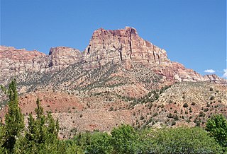
Johnson Mountain is a 6,106-foot (1,861 m) Navajo Sandstone summit located in Zion National Park, in Washington County of southwest Utah, United States.

Altar of Sacrifice is a 7,505-foot (2,288 m) Navajo Sandstone mountain in Zion National Park in Washington County, Utah, United States, that is part of the Towers of the Virgin.

Mountain of the Sun is a 6,722-foot (2,049 m) elevation Navajo Sandstone summit located in Zion National Park, in Washington County of southwest Utah, United States. Mountain of the Sun is situated immediately east of Court of the Patriarchs, and south of Zion Lodge, towering 2,500 feet above the lodge and the floor of Zion Canyon. It is set on the east side of the North Fork of the Virgin River which drains precipitation runoff from this mountain. Its neighbors include The Sentinel, Mount Spry, The East Temple, and Mount Moroni. This feature's name was officially adopted in 1934 by the U.S. Board on Geographic Names.

Mount Majestic, also known as Majestic Mountain, is a 6,956-foot (2,120 m) elevation Navajo Sandstone double-summit mountain located in Zion National Park, in Washington County of southwest Utah, United States.
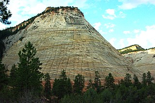
Checkerboard Mesa is an iconic 6,520+ ft elevation Navajo Sandstone summit located in Zion National Park, in Kane County of southwest Utah, United States. Checkerboard Mesa is situated immediately southwest of the park's east entrance, towering 900 feet above the Zion – Mount Carmel Highway. Its nearest neighbor is Crazy Quilt Mesa, one-half mile immediately west, and separated by Checkerboard Mesa Canyon. This canyon holds pools of rainwater which provide a vital source of water for resident bighorn sheep. This peak was originally named Checkerboard Mountain by the park's third superintendent, Preston P. Patraw. The landform's toponym was officially adopted in 1935 by the U.S. Board on Geographic Names. The descriptive name stems from the cliff's distinctive multitudinous check lines in cross-bedded white sandstone which give the impression of a checkerboard. The horizontal lines are caused by cross-bedding, a remnant of ancient sand dunes. The vertical and sub-vertical lines formed by the contraction and expansion of the sandstone caused by temperature changes, freezing and thawing cycles, in combination with wetting and drying. Precipitation runoff from this mountain drains into tributaries of the Virgin River.
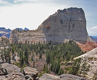
North Guardian Angel is a 7,395-foot elevation summit located in Zion National Park, in Washington County of southwest Utah, United States.

Steamboat Rock, reaching an elevation of 6,074 ft is a promontory located in the eastern Uinta Mountains, in Moffat County of northwest Colorado, United States. This iconic landmark of Dinosaur National Monument is situated at the confluence of the Green River and Yampa River. Precipitation runoff from this feature drains into the Green River. This geographical formation was originally named "Echo Rock" in John Wesley Powell's 1875 report, The Exploration of the Colorado River and Its Canyons. The Steamboat name first appeared on a 1941 United States Geological Survey map of Dinosaur National Monument. The area around it still retains the Echo Park name applied by Powell during the Powell Geographic Expedition of 1869.

Nippletop is a 6,715-foot (2,047-meter) elevation white Navajo Sandstone summit located in Zion National Park, in Washington County of southwest Utah, United States. Nippletop is situated one mile immediately west of Crazy Quilt Mesa, and one mile south of the Zion – Mount Carmel Highway, towering 1,200 feet above it. Precipitation runoff from this unofficially named mountain drains into tributaries of the Virgin River.

Beatty Point is a 7,780-foot (2,370 m) elevation summit located in the Kolob Canyons area of Zion National Park in Washington County, Utah, United States.
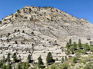
Northgate Peaks are two summits in Washington County, Utah, United States.
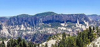
Greatheart Mesa is a 7,405 ft (2,257 m) summit in Washington County, Utah, United States.
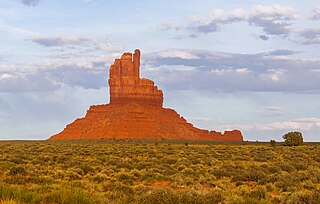
Big Indian is a 6,120-foot-elevation (1,865-meter) summit in San Juan County, Utah, United States.


